Estimated Value: $267,196 - $304,000
3
Beds
2
Baths
1,237
Sq Ft
$225/Sq Ft
Est. Value
About This Home
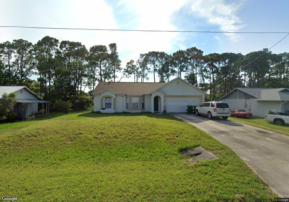
This home is located at 6576 Cedar Ave, Cocoa, FL 32927 and is currently estimated at $278,799, approximately $225 per square foot. 6576 Cedar Ave is a home located in Brevard County with nearby schools including Enterprise Elementary School, Space Coast Junior/Senior High School, and East Atlantic Prep of Brevard County.
Ownership History
Date
Name
Owned For
Owner Type
Purchase Details
Closed on
May 22, 1997
Sold by
Maronda Homes Inc Fl
Bought by
Massengill Dennis J
Current Estimated Value
Home Financials for this Owner
Home Financials are based on the most recent Mortgage that was taken out on this home.
Original Mortgage
$71,217
Outstanding Balance
$9,898
Interest Rate
8.17%
Estimated Equity
$268,901
Purchase Details
Closed on
Jan 15, 1996
Sold by
Formicola Antonietta and Formicola Massimiliano
Bought by
Maronda Homes Inc
Create a Home Valuation Report for This Property
The Home Valuation Report is an in-depth analysis detailing your home's value as well as a comparison with similar homes in the area
Home Values in the Area
Average Home Value in this Area
Purchase History
| Date | Buyer | Sale Price | Title Company |
|---|---|---|---|
| Massengill Dennis J | $71,300 | -- | |
| Maronda Homes Inc | $9,500 | -- |
Source: Public Records
Mortgage History
| Date | Status | Borrower | Loan Amount |
|---|---|---|---|
| Open | Massengill Dennis J | $71,217 |
Source: Public Records
Tax History
| Year | Tax Paid | Tax Assessment Tax Assessment Total Assessment is a certain percentage of the fair market value that is determined by local assessors to be the total taxable value of land and additions on the property. | Land | Improvement |
|---|---|---|---|---|
| 2025 | $1,055 | $78,490 | -- | -- |
| 2024 | $1,027 | $76,280 | -- | -- |
| 2023 | $1,027 | $74,060 | $0 | $0 |
| 2022 | $968 | $71,910 | $0 | $0 |
| 2021 | $970 | $69,820 | $0 | $0 |
| 2020 | $925 | $68,860 | $0 | $0 |
| 2019 | $872 | $67,320 | $0 | $0 |
| 2018 | $874 | $66,070 | $0 | $0 |
| 2017 | $875 | $64,720 | $0 | $0 |
| 2016 | $882 | $63,390 | $18,000 | $45,390 |
| 2015 | $890 | $62,950 | $15,000 | $47,950 |
| 2014 | $894 | $62,450 | $11,000 | $51,450 |
Source: Public Records
Map
Nearby Homes
- 6615 Dock Ave
- 6450 Ember Ave
- 6581 Bancroft Ave
- 6760 Cairo Rd
- 6481 La Brea Ave
- 00 Unknown
- 6815 Bryant Rd
- 6438 Hudson Rd
- 5715 Fairbridge St
- 5095 Hogan Place
- 5555 Brandon St
- 7065 Hundred Acre Dr
- 5220 Holden Rd
- 6620 Grissom Pkwy
- 5215 Holden Rd
- 0000 Grissom Pkwy
- 6375 Cable Ave
- 6990 Bryant Rd
- 5155 Mayflower St
- 5165 Patricia St
- 6588 Cedar Ave
- 6564 Cedar Ave
- 6577 Cedar Ave
- 5430 Curtis Blvd
- 6585 Dock Ave
- 6589 Cedar Ave
- 6565 Cedar Ave
- 6575 Dock Ave
- 6565 Dock Ave
- 6595 Dock Ave
- 6601 Cedar Ave
- 6555 Dock Ave
- 6612 Cedar Ave
- 6605 Dock Ave
- 6570 Elliott Ave
- 6560 Elliott Ave
- 6580 Elliott Ave
- 6550 Elliott Ave Unit 7
- 6550 Elliot
- 6590 Elliott Ave
Your Personal Tour Guide
Ask me questions while you tour the home.