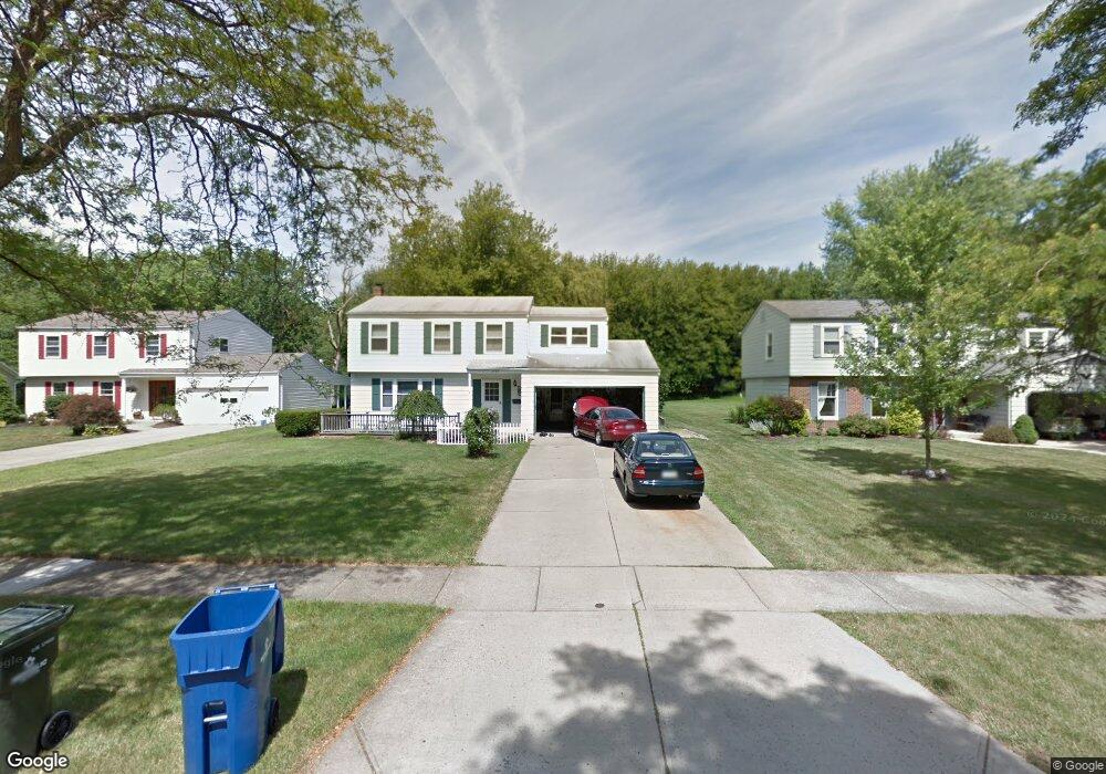
6580 Sutton Dr North Olmsted, OH 44070
Estimated Value: $324,947 - $374,000
4
Beds
2
Baths
2,123
Sq Ft
$166/Sq Ft
Est. Value
About This Home
This home is located at 6580 Sutton Dr, North Olmsted, OH 44070 and is currently estimated at $353,237, approximately $166 per square foot. 6580 Sutton Dr is a home located in Cuyahoga County with nearby schools including Chestnut Intermediate Elementary School, Pine Intermediate School, and North Olmsted Middle School.
Ownership History
Date
Name
Owned For
Owner Type
Purchase Details
Closed on
Mar 5, 1999
Sold by
Cummings John H and Cummings Sarah L
Bought by
Price Steven R and Price Dawn M
Current Estimated Value
Home Financials for this Owner
Home Financials are based on the most recent Mortgage that was taken out on this home.
Original Mortgage
$142,500
Outstanding Balance
$34,576
Interest Rate
6.78%
Estimated Equity
$318,661
Purchase Details
Closed on
Jan 1, 1975
Bought by
Cummings John H and S L
Create a Home Valuation Report for This Property
The Home Valuation Report is an in-depth analysis detailing your home's value as well as a comparison with similar homes in the area
Home Values in the Area
Average Home Value in this Area
Purchase History
| Date | Buyer | Sale Price | Title Company |
|---|---|---|---|
| Price Steven R | $150,000 | Midland Title Security Inc | |
| Cummings John H | -- | -- |
Source: Public Records
Mortgage History
| Date | Status | Borrower | Loan Amount |
|---|---|---|---|
| Open | Price Steven R | $142,500 |
Source: Public Records
Tax History Compared to Growth
Tax History
| Year | Tax Paid | Tax Assessment Tax Assessment Total Assessment is a certain percentage of the fair market value that is determined by local assessors to be the total taxable value of land and additions on the property. | Land | Improvement |
|---|---|---|---|---|
| 2024 | $6,292 | $91,805 | $19,600 | $72,205 |
| 2023 | $5,798 | $70,990 | $15,440 | $55,550 |
| 2022 | $5,767 | $70,980 | $15,440 | $55,550 |
| 2021 | $5,219 | $70,980 | $15,440 | $55,550 |
| 2020 | $5,035 | $60,660 | $13,200 | $47,460 |
| 2019 | $4,900 | $173,300 | $37,700 | $135,600 |
| 2018 | $4,827 | $60,660 | $13,200 | $47,460 |
| 2017 | $4,763 | $53,520 | $11,480 | $42,040 |
| 2016 | $4,722 | $53,520 | $11,480 | $42,040 |
| 2015 | $4,608 | $53,520 | $11,480 | $42,040 |
| 2014 | $4,608 | $51,940 | $11,130 | $40,810 |
Source: Public Records
Map
Nearby Homes
- 6617 Sutton Dr
- 6321 Brighton Dr
- 6580 Barton Rd
- 6723 Warrington Dr
- 6305 Christman Dr
- 6281 Christman Dr
- 29861 Wellington Dr
- 30247 Lorain Rd
- 30630 Lorain Rd
- 0 Stearns Rd
- 7100 Barton Rd
- 29408 Stewart Dr
- 28628 Aspen Dr
- 28625 Elder Dr
- 31134 Lorain Rd
- 30241 Sugar Sand Ln Unit 14B
- 5833 Stearns Rd
- 5920 Sherwood Dr
- 6427 Mackenzie Rd
- 27261 Cook Rd
- 6592 Sutton Dr
- 6568 Sutton Dr
- 6556 Sutton Dr
- 6604 Sutton Dr
- 6544 Sutton Dr
- 6616 Sutton Dr
- 6557 Sutton Dr
- 6593 Sutton Dr
- 6581 Sutton Dr
- 6532 Brighton Dr
- 6569 Sutton Dr
- 6605 Sutton Dr
- 6545 Sutton Dr
- 6520 Brighton Dr
- 6508 Brighton Dr
- 6531 Brighton Dr
- 30011 Sutton Dr
- 6519 Brighton Dr
- 6496 Brighton Dr
- 29979 Sutton Dr