Estimated Value: $325,000 - $350,000
2
Beds
3
Baths
1,694
Sq Ft
$201/Sq Ft
Est. Value
About This Home
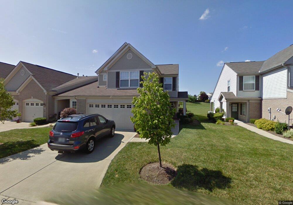
This home is located at 6581 Pondfield Ln Unit 277D, Mason, OH 45040 and is currently estimated at $339,909, approximately $200 per square foot. 6581 Pondfield Ln Unit 277D is a home located in Warren County with nearby schools including Mason Intermediate Elementary School, Mason Middle School, and William Mason High School.
Ownership History
Date
Name
Owned For
Owner Type
Purchase Details
Closed on
Apr 30, 2009
Sold by
Bilyeu Suzanne
Bought by
Stewart Phyllis and Stewart Karl
Current Estimated Value
Purchase Details
Closed on
May 11, 2004
Sold by
Hamm Kathleen M
Bought by
Bilyeu Suzanne
Home Financials for this Owner
Home Financials are based on the most recent Mortgage that was taken out on this home.
Original Mortgage
$82,500
Interest Rate
3.99%
Mortgage Type
Purchase Money Mortgage
Purchase Details
Closed on
Jul 16, 2001
Sold by
Drees Co
Bought by
Hamm Kathleen M
Home Financials for this Owner
Home Financials are based on the most recent Mortgage that was taken out on this home.
Original Mortgage
$129,350
Interest Rate
7.27%
Mortgage Type
New Conventional
Create a Home Valuation Report for This Property
The Home Valuation Report is an in-depth analysis detailing your home's value as well as a comparison with similar homes in the area
Home Values in the Area
Average Home Value in this Area
Purchase History
| Date | Buyer | Sale Price | Title Company |
|---|---|---|---|
| Stewart Phyllis | $148,500 | Lawyers Title Of Cinti | |
| Bilyeu Suzanne | $165,000 | Cambridge Land Title | |
| Hamm Kathleen M | $161,806 | -- |
Source: Public Records
Mortgage History
| Date | Status | Borrower | Loan Amount |
|---|---|---|---|
| Previous Owner | Bilyeu Suzanne | $82,500 | |
| Previous Owner | Hamm Kathleen M | $129,350 |
Source: Public Records
Tax History Compared to Growth
Tax History
| Year | Tax Paid | Tax Assessment Tax Assessment Total Assessment is a certain percentage of the fair market value that is determined by local assessors to be the total taxable value of land and additions on the property. | Land | Improvement |
|---|---|---|---|---|
| 2024 | $4,026 | $99,200 | $24,500 | $74,700 |
| 2023 | $3,658 | $76,146 | $10,675 | $65,471 |
| 2022 | $3,611 | $76,146 | $10,675 | $65,471 |
| 2021 | $3,421 | $76,146 | $10,675 | $65,471 |
| 2020 | $3,270 | $62,416 | $8,750 | $53,666 |
| 2019 | $3,007 | $62,416 | $8,750 | $53,666 |
| 2018 | $3,017 | $62,416 | $8,750 | $53,666 |
| 2017 | $2,646 | $51,125 | $7,291 | $43,834 |
| 2016 | $2,726 | $51,125 | $7,291 | $43,834 |
| 2015 | $1,366 | $51,125 | $7,291 | $43,834 |
| 2014 | $2,738 | $47,780 | $6,810 | $40,970 |
| 2013 | $2,744 | $61,340 | $8,750 | $52,590 |
Source: Public Records
Map
Nearby Homes
- 6674 Villager Place Unit 153D
- 6768 Pondfield Ln Unit 271E
- 4109 Old Manchester Ct
- 3905 Brantford Way Unit B3905
- 6565 Covefield Ct
- 6550 Villagefield Dr
- 6545 Farmbrooke Ct
- 6551 Farmbrooke Ct
- 4427 Towneside Ct
- 6309 Inverness Way
- 6788 Summer Field Dr
- 3900 St Andrews Ct
- 4762 Flagstone Dr
- 6441 Eagleview Dr
- 6486 Prestwick Ct
- 6572 Eagle View Dr
- 711 Eagle View Ct
- 6802 Parklake Dr
- 618 Bunker Ln
- 6338 Coverage Ct
- 6583 Pondfield Ln Unit 277C
- 6575 Pondfield Ln Unit 278A
- 6585 Pondfield Ln Unit 277B
- 6573 Pondfield Ln Unit 278B
- 6587 Pondfield Ln Unit 277A
- 6571 Pondfield Ln Unit 278C
- 6569 Pondfield Ln Unit 278D
- 4175 Fieldsedge Dr Unit 283D
- 4173 Fieldsedge Dr Unit 283C
- 4098 E Village Dr
- 4098 East Village Dr Unit 276G
- 4100 E Village Dr
- 4096 East Village Dr Unit 276H
- 4102 East Village Dr Unit 276E
- 4102 E East Village Dr
- 4096 E Village Dr
- 4100 East Village Dr
- 4104 E Village Dr
- 4104 East Village Dr Unit 276D
- 4102 E Village Dr