Estimated Value: $370,000 - $391,000
4
Beds
3
Baths
1,916
Sq Ft
$200/Sq Ft
Est. Value
About This Home
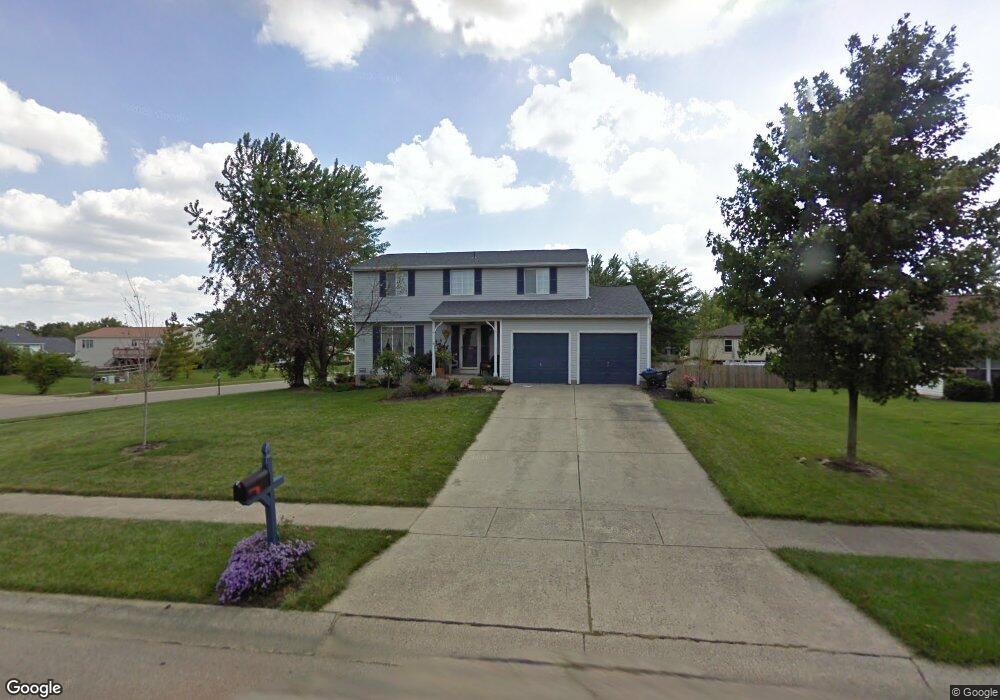
This home is located at 6585 Fernshire Ct, Mason, OH 45040 and is currently estimated at $382,272, approximately $199 per square foot. 6585 Fernshire Ct is a home located in Warren County with nearby schools including Mason Intermediate Elementary School, Mason Middle School, and William Mason High School.
Ownership History
Date
Name
Owned For
Owner Type
Purchase Details
Closed on
May 9, 2014
Sold by
Mccann Jonathan D and Mccann Kathryn D
Bought by
Dewu Zheng and Lin Lan
Current Estimated Value
Purchase Details
Closed on
Sep 13, 1990
Sold by
Schlenker Michael and Schlenker Joyc
Bought by
Mccann and Mccann Jonathan D
Purchase Details
Closed on
Jun 9, 1987
Sold by
Ryan Homes & Inc
Bought by
Schlenker Schlenker and Schlenker Michael
Purchase Details
Closed on
Mar 31, 1987
Sold by
Provident Bank & The
Bought by
Ryan Homes & Inc
Purchase Details
Closed on
Mar 31, 1986
Sold by
P Development Company
Bought by
Provident Bank & The
Purchase Details
Closed on
Jul 20, 1983
Sold by
P Development Company
Bought by
P Development Company
Create a Home Valuation Report for This Property
The Home Valuation Report is an in-depth analysis detailing your home's value as well as a comparison with similar homes in the area
Home Values in the Area
Average Home Value in this Area
Purchase History
| Date | Buyer | Sale Price | Title Company |
|---|---|---|---|
| Dewu Zheng | $150,000 | Prodigy Title Agency | |
| Mccann | $97,000 | -- | |
| Schlenker Schlenker | $77,700 | -- | |
| Ryan Homes & Inc | $12,000 | -- | |
| Provident Bank & The | -- | -- | |
| P Development Company | -- | -- |
Source: Public Records
Tax History Compared to Growth
Tax History
| Year | Tax Paid | Tax Assessment Tax Assessment Total Assessment is a certain percentage of the fair market value that is determined by local assessors to be the total taxable value of land and additions on the property. | Land | Improvement |
|---|---|---|---|---|
| 2024 | $3,927 | $96,760 | $24,500 | $72,260 |
| 2023 | $3,592 | $74,781 | $10,762 | $64,018 |
| 2022 | $3,546 | $74,781 | $10,763 | $64,019 |
| 2021 | $3,359 | $74,781 | $10,763 | $64,019 |
| 2020 | $3,185 | $60,799 | $8,750 | $52,049 |
| 2019 | $2,928 | $60,799 | $8,750 | $52,049 |
| 2018 | $2,938 | $60,799 | $8,750 | $52,049 |
| 2017 | $2,698 | $52,119 | $8,274 | $43,845 |
| 2016 | $2,779 | $52,119 | $8,274 | $43,845 |
| 2015 | $1,392 | $52,119 | $8,274 | $43,845 |
| 2014 | $2,791 | $48,710 | $7,730 | $40,970 |
| 2013 | $2,797 | $55,130 | $8,750 | $46,380 |
Source: Public Records
Map
Nearby Homes
- 6070 Fireside Dr Unit 45
- 6138 Nicholas Way
- 6387 Coverage Ct
- 6369 Coverage Ct
- 6403 Coverage Ct
- 6357 Coverage Ct
- 6383 Coverage Ct
- 6407 Coverage Ct
- 6375 Coverage Ct
- 6365 Coverage Ct
- 6361 Coverage Ct
- 6379 Coverage Ct
- 6411 Coverage Ct
- 6126 Nicholas Way
- 6146 Nicholas Way
- 6150 Nicholas Way
- 6358 Coverage Ct
- 6362 Coverage Ct
- 6134 Nicholas Way
- 6142 Nicholas Way
- 6603 Fernshire Ct
- 6173 Fireside Dr
- 1334 Firethorne Dr
- 1334 Firethorn Dr
- 6588 Fernshire Ct
- 6140 Fireside Dr
- 6156 Fireside Dr
- 1298 Firethorn Dr
- 6615 Fernshire Ct
- 1336 Firethorn Dr
- 6614 Fernshire Ct
- 6120 Fireside Dr Unit 35
- 1294 Firethorn Dr
- 1329 Firethorn Dr
- 1338 Firethorn Dr
- 6118 Fireside Dr Unit 36
- 6627 Fernshire Ct
- 6116 Fireside Dr
- 6630 Fernshire Ct
- 1333 Firethorn Dr