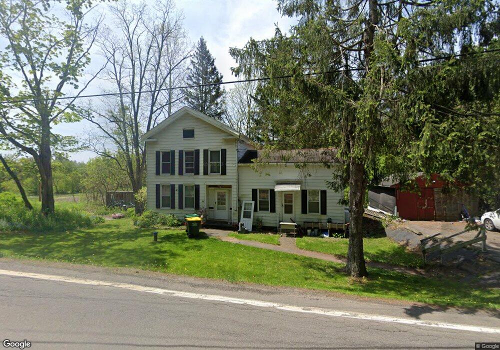
6585 State Route 79 Chenango Forks, NY 13746
Estimated Value: $106,000 - $196,000
3
Beds
2
Baths
1,639
Sq Ft
$88/Sq Ft
Est. Value
About This Home
This home is located at 6585 State Route 79, Chenango Forks, NY 13746 and is currently estimated at $143,424, approximately $87 per square foot. 6585 State Route 79 is a home located in Broome County with nearby schools including Chenango Forks Elementary School, Chenango Forks Middle School, and Chenango Forks High School.
Ownership History
Date
Name
Owned For
Owner Type
Purchase Details
Closed on
Apr 25, 2017
Sold by
Aukema Douglas and Aukema Patricia Ann
Bought by
Lipps Sharon L and Aukema James D
Current Estimated Value
Purchase Details
Closed on
Mar 2, 2017
Sold by
Aukema Douglas George and Aukema Patricia Ann
Bought by
Lipps Sharon L and Aukema James D
Purchase Details
Closed on
May 30, 2002
Sold by
Trabucchi Robert N
Bought by
Aukema Douglas
Create a Home Valuation Report for This Property
The Home Valuation Report is an in-depth analysis detailing your home's value as well as a comparison with similar homes in the area
Home Values in the Area
Average Home Value in this Area
Purchase History
| Date | Buyer | Sale Price | Title Company |
|---|---|---|---|
| Lipps Sharon L | -- | None Available | |
| Lipps Sharon L | -- | None Available | |
| Aukema Douglas | $34,900 | John Rosenkrans |
Source: Public Records
Tax History Compared to Growth
Tax History
| Year | Tax Paid | Tax Assessment Tax Assessment Total Assessment is a certain percentage of the fair market value that is determined by local assessors to be the total taxable value of land and additions on the property. | Land | Improvement |
|---|---|---|---|---|
| 2024 | $2,590 | $75,500 | $17,600 | $57,900 |
| 2023 | $2,603 | $75,500 | $17,600 | $57,900 |
| 2022 | $2,540 | $75,500 | $17,600 | $57,900 |
| 2021 | $2,443 | $75,500 | $17,600 | $57,900 |
| 2020 | $2,526 | $75,500 | $17,600 | $57,900 |
| 2019 | -- | $75,500 | $17,600 | $57,900 |
| 2018 | $3,280 | $97,500 | $17,600 | $79,900 |
| 2017 | $3,253 | $97,500 | $17,600 | $79,900 |
| 2016 | $3,262 | $97,500 | $17,600 | $79,900 |
| 2015 | -- | $97,500 | $11,900 | $85,600 |
| 2014 | -- | $97,500 | $11,900 | $85,600 |
Source: Public Records
Map
Nearby Homes
- 6633 State Route 79
- 13 Parsons Rd
- 6667 State Route 79
- 15 River Ln
- 68 Marshman Rd
- 226 Knapp Hill Rd
- 309 Parsons Rd
- 120 Steed Rd
- 198 Conklin Hill Rd
- 248 County Road 1
- 446 Conklin Hill Rd
- 434 Cloverdale Rd
- 13 Warner Rd
- 4 Beartown Rd
- 1979 State Route 12
- 87 Pamela Dr
- 197 Port Rd
- 603 Brotzman Rd
- 494 Brotzman Rd
- 101 Palmer Hill Rd
- 6591 State Route 79
- 6588 State Route 79
- 6600 State Route 79
- 6611 State Route 79
- 6617 State Route 79
- 2625 State Highway 12
- 41 Parsons Rd
- 39 Parsons Rd
- 6633 State Route 79
- 30 Jenks Rd
- 73 Old Mill Rd
- 45 Depot St
- 18 Knapp Hill Rd
- 6633 Nys Rte 79
- 2645 State Route 12 Unit NYS
- 11 Parsons Rd
- 9 Parsons Rd
- 43 Depot St
- 4 Depot St
- 5 Parsons Rd