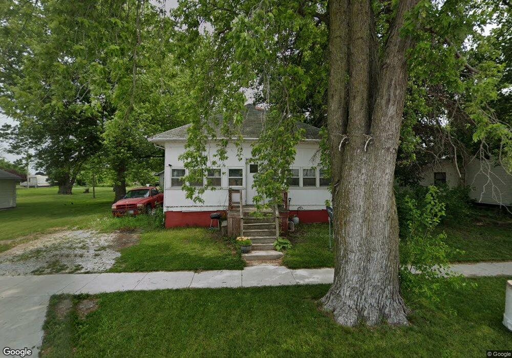
659 W Davis St Bushnell, IL 61422
Estimated Value: $55,000 - $68,000
3
Beds
--
Bath
976
Sq Ft
$61/Sq Ft
Est. Value
About This Home
This home is located at 659 W Davis St, Bushnell, IL 61422 and is currently estimated at $59,273, approximately $60 per square foot. 659 W Davis St is a home located in McDonough County with nearby schools including Bushnell-Prairie City Elementary School, Bushnell-Prairie City Junior High School, and Bushnell-Prairie City High School.
Ownership History
Date
Name
Owned For
Owner Type
Purchase Details
Closed on
Oct 6, 2015
Sold by
Griffitts Kraig and Griffitts Ashley
Bought by
Arnold Edward D
Current Estimated Value
Home Financials for this Owner
Home Financials are based on the most recent Mortgage that was taken out on this home.
Original Mortgage
$52,607
Outstanding Balance
$41,391
Interest Rate
3.88%
Mortgage Type
VA
Estimated Equity
$17,882
Purchase Details
Closed on
Sep 12, 2008
Sold by
Klinedinst Donald L and Klinedinst Debra A
Bought by
Griffitts Kraig and Griffitts Ashley
Home Financials for this Owner
Home Financials are based on the most recent Mortgage that was taken out on this home.
Original Mortgage
$53,500
Interest Rate
6.57%
Mortgage Type
New Conventional
Purchase Details
Closed on
Jul 31, 2007
Sold by
Mason Brady L and Mason Toni L
Bought by
Klinedinst Donald L and Klinedinst Debra A
Purchase Details
Closed on
Mar 10, 2005
Sold by
Mason Sara J
Bought by
Mason Brady L
Create a Home Valuation Report for This Property
The Home Valuation Report is an in-depth analysis detailing your home's value as well as a comparison with similar homes in the area
Home Values in the Area
Average Home Value in this Area
Purchase History
| Date | Buyer | Sale Price | Title Company |
|---|---|---|---|
| Arnold Edward D | $52,000 | None Available | |
| Griffitts Kraig | $50,000 | None Available | |
| Klinedinst Donald L | $42,000 | None Available | |
| Mason Brady L | -- | None Available |
Source: Public Records
Mortgage History
| Date | Status | Borrower | Loan Amount |
|---|---|---|---|
| Open | Arnold Edward D | $52,607 | |
| Previous Owner | Griffitts Kraig | $53,500 |
Source: Public Records
Tax History Compared to Growth
Tax History
| Year | Tax Paid | Tax Assessment Tax Assessment Total Assessment is a certain percentage of the fair market value that is determined by local assessors to be the total taxable value of land and additions on the property. | Land | Improvement |
|---|---|---|---|---|
| 2024 | $772 | $14,390 | $1,875 | $12,515 |
| 2023 | $736 | $14,238 | $1,855 | $12,383 |
| 2022 | $618 | $12,871 | $1,677 | $11,194 |
| 2021 | $570 | $12,323 | $1,606 | $10,717 |
| 2020 | $569 | $13,732 | $1,583 | $12,149 |
| 2019 | $616 | $12,659 | $1,649 | $11,010 |
| 2018 | $617 | $12,924 | $1,684 | $11,240 |
| 2017 | $618 | $12,739 | $1,660 | $11,079 |
| 2016 | $538 | $11,779 | $1,535 | $10,244 |
| 2015 | $546 | $11,779 | $1,535 | $10,244 |
| 2014 | $589 | $11,600 | $1,512 | $10,088 |
| 2013 | $579 | $12,529 | $1,633 | $10,896 |
Source: Public Records
Map
Nearby Homes
- 425 N Jackson St
- 555 N Jackson St
- 310 N Dean St
- 651 N Washington St
- 195 W Hail St
- 134 W Osborne St
- 1091 N Jackson St
- 295 W Harris Ave
- 1024 W Main St
- 651 N Sperry St
- 924 N Crafford St
- 994 N Crafford St
- 4 Hiel Dr
- 777 Cole St
- 14 Hillcrest Dr
- 20620 N 2300 Rd
- 20620 N 2300th Rd
- 18520 N 1450th Rd
- 16905 E 1600th St
- 22561 N Cornerstone Rd
- 661 W Davis St
- 625 W Davis St
- 605 W Davis St
- 681 W Davis St
- 697 W Davis St
- 650 W Barnes St
- 636 W Barnes St
- 668 W Barnes St
- 250 Grant St
- 630 W Davis St
- 594 W Barnes St
- 255 Grant St
- 580 W Barnes St
- 695 W Barnes St
- 558 W Barnes St
- 539 W Davis St
- 625 W Barnes St
- 615 W Barnes St
- 675 W Barnes St
- 605 W Barnes St