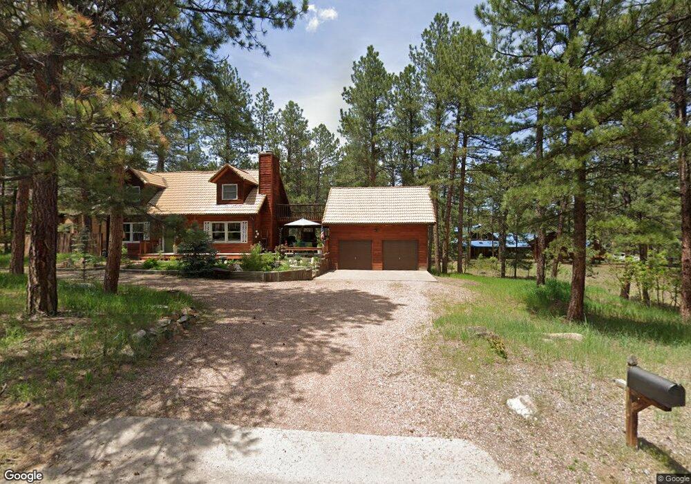
659 Weston Rd Larkspur, CO 80118
Estimated Value: $650,000 - $966,000
3
Beds
2
Baths
1,490
Sq Ft
$511/Sq Ft
Est. Value
About This Home
This home is located at 659 Weston Rd, Larkspur, CO 80118 and is currently estimated at $761,794, approximately $511 per square foot. 659 Weston Rd is a home located in Douglas County with nearby schools including Larkspur Elementary School, Castle Rock Middle School, and Castle View High School.
Ownership History
Date
Name
Owned For
Owner Type
Purchase Details
Closed on
Nov 7, 2002
Sold by
Burt Nathan Allen and Burt Lisa A
Bought by
Burt Lisa A
Current Estimated Value
Home Financials for this Owner
Home Financials are based on the most recent Mortgage that was taken out on this home.
Original Mortgage
$222,600
Outstanding Balance
$93,100
Interest Rate
6%
Estimated Equity
$668,694
Purchase Details
Closed on
Nov 23, 1988
Sold by
Tuthill Steven W and Tuthill Lee Anne
Bought by
Burt Nathan Allen and Burt Lisa A
Purchase Details
Closed on
Aug 6, 1984
Sold by
Broyles Leland A
Bought by
Tuthill Steven W and Tuthill Lee Anne
Create a Home Valuation Report for This Property
The Home Valuation Report is an in-depth analysis detailing your home's value as well as a comparison with similar homes in the area
Home Values in the Area
Average Home Value in this Area
Purchase History
| Date | Buyer | Sale Price | Title Company |
|---|---|---|---|
| Burt Lisa A | -- | -- | |
| Burt Nathan Allen | $114,300 | -- | |
| Tuthill Steven W | $20,000 | -- |
Source: Public Records
Mortgage History
| Date | Status | Borrower | Loan Amount |
|---|---|---|---|
| Open | Burt Lisa A | $222,600 |
Source: Public Records
Tax History Compared to Growth
Tax History
| Year | Tax Paid | Tax Assessment Tax Assessment Total Assessment is a certain percentage of the fair market value that is determined by local assessors to be the total taxable value of land and additions on the property. | Land | Improvement |
|---|---|---|---|---|
| 2024 | $3,656 | $41,200 | $12,570 | $28,630 |
| 2023 | $3,693 | $41,200 | $12,570 | $28,630 |
| 2022 | $2,767 | $29,210 | $8,590 | $20,620 |
| 2021 | $2,865 | $29,210 | $8,590 | $20,620 |
| 2020 | $2,661 | $27,700 | $7,430 | $20,270 |
| 2019 | $2,670 | $27,700 | $7,430 | $20,270 |
| 2018 | $2,324 | $23,690 | $6,800 | $16,890 |
| 2017 | $2,184 | $23,690 | $6,800 | $16,890 |
| 2016 | $2,035 | $21,710 | $6,530 | $15,180 |
| 2015 | $1,990 | $21,710 | $6,530 | $15,180 |
| 2014 | $1,686 | $17,240 | $4,700 | $12,540 |
Source: Public Records
Map
Nearby Homes
- 533 Tenderfoot Dr
- 682 Copper Fox Place
- 720 Copper Fox Place
- 773 Copper Fox Place
- 648 Copper Fox Place Unit 5
- 665 Copper Fox Place
- 7076 Boreas Rd
- 670 Independence Dr
- 7737 Taylor Cir
- 0 E Cherry Creek Rd Unit 2541327
- 0 E Cherry Creek Rd Unit REC1786246
- 7317 Fremont Place
- 691 Cumberland Rd
- 929 Tenderfoot Dr
- 1151 Kenosha Dr
- 950 Tenderfoot Dr
- 7596 Rollins Dr
- 7994 Monarch Rd
- 1210 Kenosha Dr
- 1600 Independence Dr
- 715 Weston Rd
- 725 Weston Rd
- 788 Kenosha Dr
- 666 Weston Rd
- 688 Weston Rd
- 638 Weston Rd
- 720 Weston Rd
- 623 Weston Rd
- 805 Kenosha Dr
- 604 Weston Rd
- 740 Weston Rd
- 837 Kenosha Dr
- 775 Kenosha Dr
- 750 Kenosha Dr
- 860 Kenosha Dr
- 593 Tenderfoot Dr
- 744 Weston Rd
- 575 Tenderfoot Dr
- 545 Tenderfoot Dr
- 623 Tenderfoot Dr