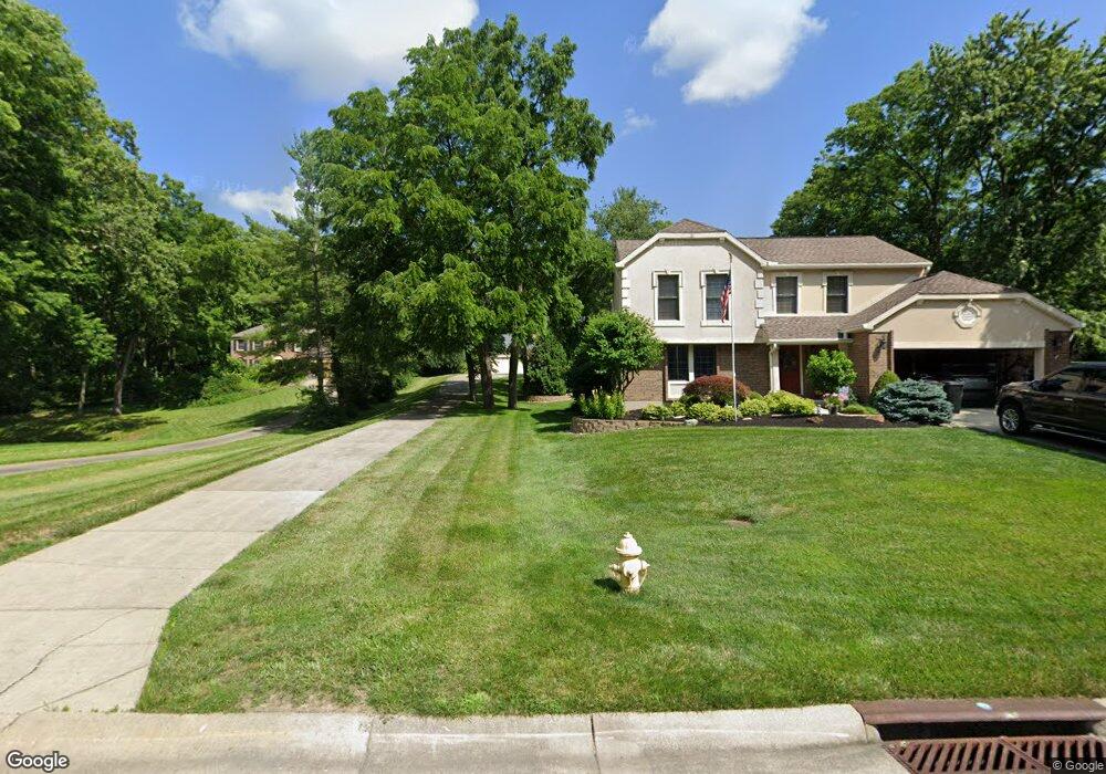
6593 Chessie Dr West Chester, OH 45069
West Chester Township NeighborhoodEstimated Value: $432,000 - $496,000
4
Beds
3
Baths
2,434
Sq Ft
$189/Sq Ft
Est. Value
About This Home
This home is located at 6593 Chessie Dr, West Chester, OH 45069 and is currently estimated at $459,732, approximately $188 per square foot. 6593 Chessie Dr is a home located in Butler County with nearby schools including Adena Elementary School, Lakota Ridge Junior School, and Lakota West High School.
Ownership History
Date
Name
Owned For
Owner Type
Purchase Details
Closed on
Feb 22, 2002
Sold by
Vezeau Lisa
Bought by
Vezeau William
Current Estimated Value
Home Financials for this Owner
Home Financials are based on the most recent Mortgage that was taken out on this home.
Original Mortgage
$156,100
Outstanding Balance
$64,044
Interest Rate
6.95%
Mortgage Type
Stand Alone Second
Estimated Equity
$395,688
Purchase Details
Closed on
Sep 11, 1997
Sold by
Austin Ronald M
Bought by
Vezeau William M
Home Financials for this Owner
Home Financials are based on the most recent Mortgage that was taken out on this home.
Original Mortgage
$158,525
Interest Rate
7.44%
Mortgage Type
New Conventional
Purchase Details
Closed on
Oct 1, 1991
Purchase Details
Closed on
Mar 1, 1987
Create a Home Valuation Report for This Property
The Home Valuation Report is an in-depth analysis detailing your home's value as well as a comparison with similar homes in the area
Home Values in the Area
Average Home Value in this Area
Purchase History
| Date | Buyer | Sale Price | Title Company |
|---|---|---|---|
| Vezeau William | -- | -- | |
| Vezeau William M | $186,500 | -- | |
| -- | $157,000 | -- | |
| -- | $146,700 | -- |
Source: Public Records
Mortgage History
| Date | Status | Borrower | Loan Amount |
|---|---|---|---|
| Open | Vezeau William | $156,100 | |
| Closed | Vezeau William M | $158,525 |
Source: Public Records
Tax History Compared to Growth
Tax History
| Year | Tax Paid | Tax Assessment Tax Assessment Total Assessment is a certain percentage of the fair market value that is determined by local assessors to be the total taxable value of land and additions on the property. | Land | Improvement |
|---|---|---|---|---|
| 2024 | $5,166 | $122,170 | $18,370 | $103,800 |
| 2023 | $5,129 | $119,840 | $18,370 | $101,470 |
| 2022 | $5,078 | $89,100 | $18,370 | $70,730 |
| 2021 | $4,632 | $85,730 | $18,370 | $67,360 |
| 2020 | $4,742 | $85,730 | $18,370 | $67,360 |
| 2019 | $7,364 | $76,840 | $21,850 | $54,990 |
| 2018 | $4,465 | $76,840 | $21,850 | $54,990 |
| 2017 | $4,544 | $76,840 | $21,850 | $54,990 |
| 2016 | $4,422 | $70,400 | $21,850 | $48,550 |
| 2015 | $4,416 | $70,400 | $21,850 | $48,550 |
| 2014 | $4,362 | $70,400 | $21,850 | $48,550 |
| 2013 | $4,362 | $67,600 | $23,410 | $44,190 |
Source: Public Records
Map
Nearby Homes
- 6612 Pullman Ct
- 6605 San Mateo Dr
- 6779 Windwood Dr
- 6592 Pullman Ct
- 10155 Golay Ave
- 6791 Cork Dr
- Palisades Plan at West Ridge
- Brentwood Plan at West Ridge
- Wilshire Plan at West Ridge
- Moorgate Plan at West Ridge - Noble
- Everton Plan at West Ridge - Noble
- Kingsmark Plan at West Ridge - Prestige
- 6812 Cork Dr
- 6816 Cork Dr
- 6724 Maverick Dr
- 9647 Friar Tuck Dr
- 7089 Windwood Dr
- 9377 Dundee Dr
- 7327 Dimmick Rd
- 9750 Cincinnati Columbus Rd
- 6601 Chessie Dr
- 6585 Chessie Dr
- 9743 Caseys Crossing
- 6609 Chessie Dr
- 6735 Old Station Dr
- 6575 Chessie Dr
- 6741 Old Station Dr
- 6727 Old Station Dr
- 6719 Old Station Dr
- 9738 Caseys Crossing
- 6711 Old Station Dr
- 6619 Chessie Dr
- 6745 Old Station Dr
- 6705 Old Station Dr
- 6699 Old Station Dr
- 6596 Chessie Dr
- 6629 Chessie Dr
- 9746 Caseys Crossing
- 9777 Caseys Crossing
- 6749 Old Station Dr