


Estimated payment $1,590/month
Highlights
- Heated Spa
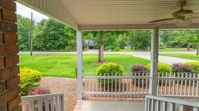
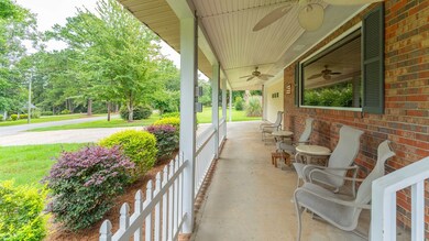
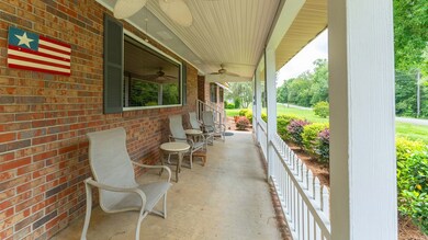
- Covered Patio or Porch
- Recessed Lighting
- Traditional Architecture
- Separate Outdoor Workshop
- Laundry Room
About This Home
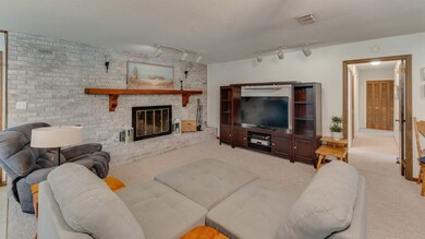
JUST REDUCED! Traditional Brick home tucked away in a quiet neighborhood, yet conveniently located near Highway 84 for quick commuting, and close to shopping, hospital, and other dining amenities. As you enter the front door, you will see a large great room that gives you several seating arrangements: dining, fireplace and TV, lounging. A beautiful back yard will provide you with shady days and blooming plants to enjoy family gatherings. The large storage building workshop is wired and perfect for landscaping, construction tools. As you exit at the kitchen door to the nice large back concrete pad, there is a covered patio that has a Hot Tub and Swing. Call your Agent today to schedule a viewing. You won't be disappointed. Yes, it might be a 1978 Vintage home but has been maintained and waiting for you to enjoy and/or add your deco theme to!
Listing Agent
Realty Mart Inc. Brokerage Phone: 2293778007 License #133246 Listed on: 08/01/2025
Home Details
Home Type
- Single Family
Est. Annual Taxes
- $2,011
Year Built
- Built in 1978
Lot Details
- 0.57 Acre Lot
- Back Yard Fenced
- Chain Link Fence
Parking
- 2 Car Garage
- Parking Pad
- Garage Door Opener
- Open Parking
Home Design
- Traditional Architecture
- Brick Exterior Construction
- Slab Foundation
- Shingle Roof
- Vinyl Siding
Interior Spaces
- 1,682 Sq Ft Home
- 1-Story Property
- Sheet Rock Walls or Ceilings
- Ceiling Fan
- Recessed Lighting
- Fireplace Features Masonry
- Blinds
- Utility Room
- Laundry Room
- Fire and Smoke Detector
Kitchen
- Range Hood
- Microwave
- Dishwasher
Flooring
- Parquet
- Carpet
Bedrooms and Bathrooms
- 3 Bedrooms
- 2 Full Bathrooms
Outdoor Features
- Heated Spa
- Covered Patio or Porch
- Separate Outdoor Workshop
- Outdoor Storage
Utilities
- Central Heating and Cooling System
- Electric Water Heater
- High Speed Internet
Community Details
- Karoga Estates Subdivision
- The community has rules related to covenants, conditions, and restrictions
Listing and Financial Details
- Assessor Parcel Number C0380015
Map
Home Values in the Area
Average Home Value in this Area
Tax History
| Year | Tax Paid | Tax Assessment Tax Assessment Total Assessment is a certain percentage of the fair market value that is determined by local assessors to be the total taxable value of land and additions on the property. | Land | Improvement |
|---|---|---|---|---|
| 2024 | $2,473 | $67,831 | $4,554 | $63,277 |
| 2023 | $1,572 | $47,964 | $4,800 | $43,164 |
| 2022 | $1,643 | $47,964 | $4,800 | $43,164 |
| 2021 | $1,647 | $47,964 | $4,800 | $43,164 |
| 2020 | $1,651 | $47,964 | $4,800 | $43,164 |
| 2019 | $1,651 | $47,964 | $4,800 | $43,164 |
| 2018 | $1,566 | $47,964 | $4,800 | $43,164 |
| 2017 | $1,504 | $47,964 | $4,800 | $43,164 |
| 2016 | $1,308 | $41,589 | $4,800 | $36,789 |
| 2015 | $1,293 | $41,589 | $4,800 | $36,789 |
| 2014 | $1,291 | $41,589 | $4,800 | $36,789 |
| 2013 | -- | $38,208 | $4,800 | $33,408 |
Property History
| Date | Event | Price | List to Sale | Price per Sq Ft |
|---|---|---|---|---|
| 11/07/2025 11/07/25 | Pending | -- | -- | -- |
| 09/19/2025 09/19/25 | Price Changed | $269,900 | -5.3% | $160 / Sq Ft |
| 08/05/2025 08/05/25 | For Sale | $285,000 | 0.0% | $169 / Sq Ft |
| 08/03/2025 08/03/25 | Off Market | $285,000 | -- | -- |
| 08/01/2025 08/01/25 | For Sale | $285,000 | -- | $169 / Sq Ft |
Purchase History
| Date | Type | Sale Price | Title Company |
|---|---|---|---|
| Warranty Deed | -- | -- | |
| Gift Deed | -- | -- | |
| Deed | $125,000 | -- | |
| Deed | $89,500 | -- |
Source: Southwest Georgia Board of REALTORS®
MLS Number: 14181
APN: C0380-00000-015-000
- 21 24th St NE
- 2600 U S 84
- 0 20th St NE
- 00 20th St NE
- 78.6 Ac Strickland Rd
- 0 NE Airport Rd Unit 145784
- 00 NW 9th Ave
- 711 2nd Ave NE
- 225 Helton Ln
- 236 Helton Ln
- Lot #15, 3 64 Acres Oakbend Cir
- 530 6th Ave SE
- 530 6th St
- 471 4th St SE
- 481 4th St SE
- 602 4th St SE
- 309 3rd St SE
- 3109 U S 84
- 3109 U S 84
- 4761 Hadley Ferry Rd
