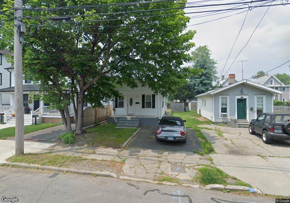
66 Hanford Ave Bridgeport, CT 06605
Black Rock NeighborhoodEstimated Value: $242,000 - $501,000
2
Beds
1
Bath
720
Sq Ft
$495/Sq Ft
Est. Value
About This Home
This home is located at 66 Hanford Ave, Bridgeport, CT 06605 and is currently estimated at $356,686, approximately $495 per square foot. 66 Hanford Ave is a home located in Fairfield County with nearby schools including Black Rock School, Bassick High School, and Park City Prep Charter School.
Ownership History
Date
Name
Owned For
Owner Type
Purchase Details
Closed on
Feb 11, 2020
Sold by
Deutsche Bank Natl T Co
Bought by
Sanchez Oswaldo
Current Estimated Value
Purchase Details
Closed on
Sep 11, 2018
Sold by
Dawson Janet
Bought by
Deutsche Bk Natl T Co
Purchase Details
Closed on
Dec 24, 2014
Sold by
Mad Max Llc
Bought by
Dawson Janet
Purchase Details
Closed on
Nov 8, 2010
Sold by
Dawson Janet
Bought by
Mad Max Llc
Create a Home Valuation Report for This Property
The Home Valuation Report is an in-depth analysis detailing your home's value as well as a comparison with similar homes in the area
Home Values in the Area
Average Home Value in this Area
Purchase History
| Date | Buyer | Sale Price | Title Company |
|---|---|---|---|
| Sanchez Oswaldo | $69,300 | None Available | |
| Sanchez Oswaldo | $69,300 | None Available | |
| Deutsche Bk Natl T Co | -- | -- | |
| Dawson Janet | -- | -- | |
| Mad Max Llc | -- | -- | |
| Deutsche Bk Natl T Co | -- | -- | |
| Dawson Janet | -- | -- | |
| Mad Max Llc | -- | -- |
Source: Public Records
Mortgage History
| Date | Status | Borrower | Loan Amount |
|---|---|---|---|
| Previous Owner | Mad Max Llc | $86,800 | |
| Previous Owner | Mad Max Llc | $47,450 |
Source: Public Records
Tax History Compared to Growth
Tax History
| Year | Tax Paid | Tax Assessment Tax Assessment Total Assessment is a certain percentage of the fair market value that is determined by local assessors to be the total taxable value of land and additions on the property. | Land | Improvement |
|---|---|---|---|---|
| 2025 | $6,948 | $159,900 | $127,410 | $32,490 |
| 2024 | $6,948 | $159,900 | $127,410 | $32,490 |
| 2023 | $6,948 | $159,900 | $127,410 | $32,490 |
| 2022 | $6,948 | $159,900 | $127,410 | $32,490 |
| 2021 | $6,948 | $159,900 | $127,410 | $32,490 |
| 2020 | $6,225 | $115,300 | $75,640 | $39,660 |
| 2019 | $6,225 | $115,300 | $75,640 | $39,660 |
| 2018 | $6,269 | $115,300 | $75,640 | $39,660 |
| 2017 | $6,269 | $115,300 | $75,640 | $39,660 |
| 2016 | $6,269 | $115,300 | $75,640 | $39,660 |
| 2015 | $5,415 | $128,310 | $72,060 | $56,250 |
| 2014 | $5,415 | $128,310 | $72,060 | $56,250 |
Source: Public Records
Map
Nearby Homes
- 39 Jetland Place Unit 41
- 554 Brewster St Unit 4
- 105 Fox St Unit 107
- 75 Homestead Ave Unit 77
- 20 Haddon St Unit 5
- 26 Rowsley St Unit 3
- 165 Bennett St
- 37 Rowsley St Unit 6
- 450 Davidson St
- 317 Brewster St
- 51 Princeton St
- 855 Brewster St Unit 857
- 166 Alfred St
- 167 Scofield Ave
- 361 Riverside Dr
- 82 Waldorf Ave
- 135 Whittier St
- 25 Whittier St
- 31 Whittier St
- 0 Battery Park Dr
- 60 Hanford Ave
- 78 Hanford Ave
- 82 Hanford Ave Unit 86
- 54 Hanford Ave Unit 56
- 54-56 Hanford Ave
- 8-10 Jetland Place
- 12 Jetland Place Unit 14
- 12-14 Jetland Place Unit 14
- 12-14 Jetland Place Unit 12
- 6 Jetland Place
- 8 Jetland Place Unit 10
- 8 Jetland Place Unit 1
- 8 Jetland Place Unit 2
- 42 Hanford Ave Unit 46
- 16 Jetland Place Unit 18
- 16 Jetland Place Unit 1FF
- 16 Jetland Place Unit 2nF
- 16 Jetland Place
- 59 Hanford Ave
- 59 Hanford Ave Unit 1