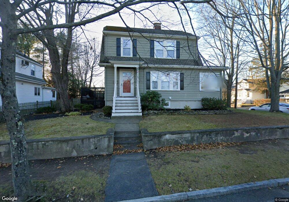
66 Highview Ave Melrose, MA 02176
Melrose East Side NeighborhoodEstimated Value: $809,000 - $917,000
3
Beds
1
Bath
1,380
Sq Ft
$626/Sq Ft
Est. Value
About This Home
This home is located at 66 Highview Ave, Melrose, MA 02176 and is currently estimated at $864,241, approximately $626 per square foot. 66 Highview Ave is a home located in Middlesex County with nearby schools including Winthrop Elementary School, Horace Mann Elementary School, and Hoover Elementary School.
Ownership History
Date
Name
Owned For
Owner Type
Purchase Details
Closed on
Jun 10, 2008
Sold by
Perella Andrea R and Perella John M
Bought by
Perella Andrea R
Current Estimated Value
Purchase Details
Closed on
May 1, 1997
Sold by
Odonnell William P and Odonnell Mary P
Bought by
Carroll Andrew J and Carroll Kristin M
Purchase Details
Closed on
Jun 29, 1990
Sold by
Smith Lester L
Bought by
Odonnell William P
Create a Home Valuation Report for This Property
The Home Valuation Report is an in-depth analysis detailing your home's value as well as a comparison with similar homes in the area
Home Values in the Area
Average Home Value in this Area
Purchase History
| Date | Buyer | Sale Price | Title Company |
|---|---|---|---|
| Perella Andrea R | -- | -- | |
| Carroll Andrew J | $184,000 | -- | |
| Odonnell William P | $179,000 | -- |
Source: Public Records
Mortgage History
| Date | Status | Borrower | Loan Amount |
|---|---|---|---|
| Open | Odonnell William P | $46,300 | |
| Previous Owner | Odonnell William P | $171,900 | |
| Previous Owner | Odonnell William P | $173,500 |
Source: Public Records
Tax History Compared to Growth
Tax History
| Year | Tax Paid | Tax Assessment Tax Assessment Total Assessment is a certain percentage of the fair market value that is determined by local assessors to be the total taxable value of land and additions on the property. | Land | Improvement |
|---|---|---|---|---|
| 2025 | $73 | $742,200 | $448,400 | $293,800 |
| 2024 | $7,100 | $715,000 | $421,200 | $293,800 |
| 2023 | $7,048 | $676,400 | $407,600 | $268,800 |
| 2022 | $7,042 | $666,200 | $407,600 | $258,600 |
| 2021 | $6,859 | $626,400 | $380,400 | $246,000 |
| 2020 | $6,473 | $585,800 | $339,700 | $246,100 |
| 2019 | $5,832 | $539,500 | $313,900 | $225,600 |
| 2018 | $5,788 | $510,900 | $285,300 | $225,600 |
| 2017 | $5,668 | $480,300 | $271,700 | $208,600 |
| 2016 | $5,513 | $447,100 | $264,900 | $182,200 |
| 2015 | $5,352 | $413,000 | $237,800 | $175,200 |
| 2014 | $5,123 | $385,800 | $210,600 | $175,200 |
Source: Public Records
Map
Nearby Homes
- 257 1st St
- 16 Plymouth Cir
- 36 Slayton Rd
- 30 Wheeler Ave
- 33 Mount Hood Terrace
- 218 Upham St
- 26 Magnolia Rd
- 118 N Woodcrest Dr
- 515 Upham St
- 1 Mill Rd
- 519 Essex St
- 46 Country Club Rd
- 110 Ellis Farm Ln
- 55 Burrell St
- 65 Beacon St
- 4 Cheever Ave
- 12B Cheever Ave
- 12C Cheever Ave
- 42 Fairfield Ave
- 5 Hammersmith Dr
- 393 E Foster St
- 58 Highview Ave
- 74 Highview Ave
- 67 Highview Ave
- 54 Highview Ave
- 389 E Foster St
- 78 Highview Ave
- 83 Highview Ave
- 390 E Foster St
- 61 Highview Ave
- 82 Highview Ave
- 50 Highview Ave
- 55 Highview Ave
- 388 E Foster St
- 414 E Foster St
- 214 Laurel St
- 415 E Foster St
- 208 Laurel St
- 385 E Foster St
- 81 Highview Ave