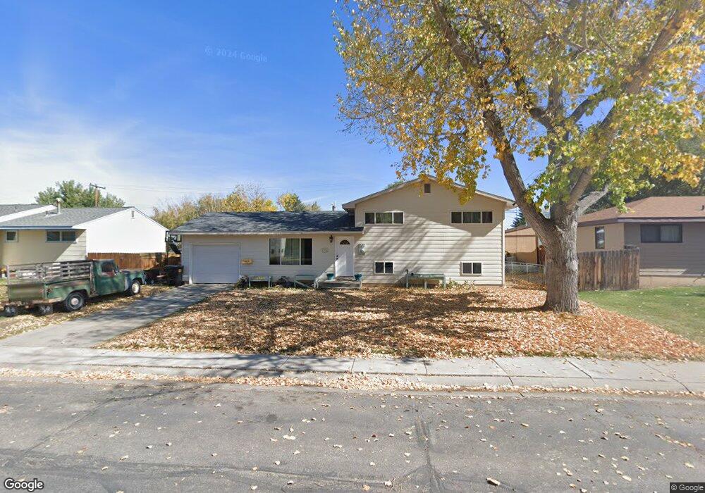
660 East Ln Unit Clinchard St. Lander, WY 82520
Estimated Value: $320,000 - $354,811
4
Beds
2
Baths
1,608
Sq Ft
$211/Sq Ft
Est. Value
About This Home
This home is located at 660 East Ln Unit Clinchard St., Lander, WY 82520 and is currently estimated at $339,703, approximately $211 per square foot. 660 East Ln Unit Clinchard St. is a home located in Fremont County with nearby schools including Lander Valley High School.
Ownership History
Date
Name
Owned For
Owner Type
Purchase Details
Closed on
Apr 6, 2017
Sold by
L M Olson Inc
Bought by
Kimsey Andrew G and Kimsey Laura Danyel
Current Estimated Value
Home Financials for this Owner
Home Financials are based on the most recent Mortgage that was taken out on this home.
Original Mortgage
$203,535
Outstanding Balance
$169,139
Interest Rate
4.16%
Mortgage Type
New Conventional
Estimated Equity
$170,564
Purchase Details
Closed on
Apr 23, 2010
Sold by
Johnston Bobby and Johnston Tracy L
Bought by
L M Olson Inc
Purchase Details
Closed on
Apr 29, 2009
Sold by
Johnston Tracy Larraine
Bought by
Johnston Bobby and Johnston Tracy
Purchase Details
Closed on
Jan 15, 2009
Sold by
Johnston Tracy L
Bought by
Johnston Bobby and Johnston Tracy L
Create a Home Valuation Report for This Property
The Home Valuation Report is an in-depth analysis detailing your home's value as well as a comparison with similar homes in the area
Home Values in the Area
Average Home Value in this Area
Purchase History
| Date | Buyer | Sale Price | Title Company |
|---|---|---|---|
| Kimsey Andrew G | -- | None Available | |
| L M Olson Inc | -- | Fremont County Title | |
| Johnston Bobby | -- | Fremont County Title | |
| Johnston Bobby | -- | None Available | |
| Johnston Bobby | -- | None Available | |
| Johnston Bobby | -- | None Available |
Source: Public Records
Mortgage History
| Date | Status | Borrower | Loan Amount |
|---|---|---|---|
| Open | Kimsey Andrew G | $203,535 |
Source: Public Records
Tax History Compared to Growth
Tax History
| Year | Tax Paid | Tax Assessment Tax Assessment Total Assessment is a certain percentage of the fair market value that is determined by local assessors to be the total taxable value of land and additions on the property. | Land | Improvement |
|---|---|---|---|---|
| 2025 | $1,884 | $18,901 | $3,988 | $14,913 |
| 2024 | $1,884 | $24,403 | $5,318 | $19,085 |
| 2023 | $1,813 | $23,677 | $5,318 | $18,359 |
| 2022 | $1,562 | $20,844 | $5,318 | $15,526 |
| 2021 | $1,446 | $18,682 | $5,318 | $13,364 |
| 2020 | $1,402 | $18,145 | $5,318 | $12,827 |
| 2019 | $1,340 | $17,071 | $4,693 | $12,378 |
| 2018 | $1,341 | $16,901 | $4,691 | $12,210 |
| 2017 | $1,323 | $16,631 | $4,691 | $11,940 |
| 2016 | $1,209 | $15,215 | $4,691 | $10,524 |
| 2015 | $1,361 | $17,325 | $4,691 | $12,634 |
| 2014 | $1,362 | $17,361 | $4,691 | $12,670 |
Source: Public Records
Map
Nearby Homes
- 665 N 9th St
- 783 Victory Ln
- 926 Hobson St
- 655 N 10th St
- 665 6th Street Ct
- 560 Washington St
- 654 W Main St
- 550 Jefferson St
- 445 Market St
- 442 Eugene St
- 835 Garfield St
- 617 Main St Unit LotWP001
- 55 Western Ave
- 960 Dabich Ave
- 200 Irwin Ln
- 167 Western Ave
- 1041 N 2nd St
- 1105 N 2nd St
- 139 Northside Dr Unit 10
- 200 Sweetwater St