Estimated Value: $178,000 - $286,384
4
Beds
1
Bath
1,032
Sq Ft
$225/Sq Ft
Est. Value
About This Home
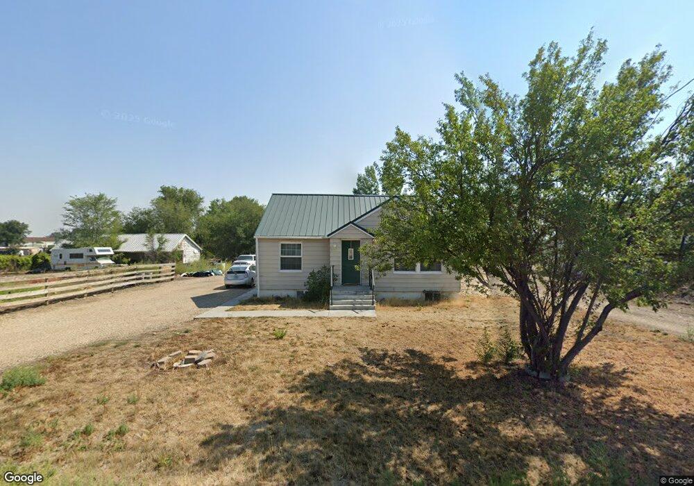
This home is located at 660 Stringer Rd, Nyssa, OR 97913 and is currently estimated at $232,192, approximately $224 per square foot. 660 Stringer Rd is a home located in Malheur County with nearby schools including Nyssa Elementary School, Nyssa Middle School, and Nyssa High School.
Ownership History
Date
Name
Owned For
Owner Type
Purchase Details
Closed on
Aug 22, 2007
Sold by
Short Jamison L
Bought by
Short Jamison L and Short Kimberley A
Current Estimated Value
Home Financials for this Owner
Home Financials are based on the most recent Mortgage that was taken out on this home.
Original Mortgage
$140,650
Outstanding Balance
$88,550
Interest Rate
6.73%
Mortgage Type
Future Advance Clause Open End Mortgage
Estimated Equity
$143,642
Purchase Details
Closed on
May 24, 2007
Sold by
Garrett Stephonie L
Bought by
Garrett Michael D
Create a Home Valuation Report for This Property
The Home Valuation Report is an in-depth analysis detailing your home's value as well as a comparison with similar homes in the area
Home Values in the Area
Average Home Value in this Area
Purchase History
| Date | Buyer | Sale Price | Title Company |
|---|---|---|---|
| Short Jamison L | -- | -- | |
| Short Jamison L | $145,000 | -- | |
| Garrett Michael D | -- | -- |
Source: Public Records
Mortgage History
| Date | Status | Borrower | Loan Amount |
|---|---|---|---|
| Open | Short Jamison L | $140,650 |
Source: Public Records
Tax History
| Year | Tax Paid | Tax Assessment Tax Assessment Total Assessment is a certain percentage of the fair market value that is determined by local assessors to be the total taxable value of land and additions on the property. | Land | Improvement |
|---|---|---|---|---|
| 2025 | $1,110 | $107,606 | $25,814 | $81,792 |
| 2024 | $1,093 | $104,472 | $28,182 | $76,290 |
| 2023 | $1,075 | $101,430 | $25,206 | $76,224 |
| 2022 | $1,075 | $98,476 | $25,997 | $72,479 |
| 2021 | $1,062 | $95,608 | $20,884 | $74,724 |
| 2020 | $1,041 | $92,824 | $22,428 | $70,396 |
| 2019 | $1,020 | $90,121 | $25,961 | $64,160 |
| 2018 | $992 | $87,497 | $25,205 | $62,292 |
| 2017 | $923 | $84,949 | $24,817 | $60,132 |
| 2016 | $933 | $82,475 | $21,789 | $60,686 |
| 2015 | $813 | $80,073 | $23,600 | $56,473 |
| 2014 | $901 | $77,741 | $21,993 | $55,748 |
Source: Public Records
Map
Nearby Homes
- 813 Reece Ave
- 617 Park Ave
- lot2 plat 2411 Oregon 201
- 904 Oak St Unit 44
- 416 N 2nd St
- 106 E Main St
- 110 E Main St
- 108 E Main St
- 112 E Main St
- 717 N 3rd St
- 705 N 2nd St
- 824 N 5th St
- 1770 N 3rd St
- TBD Sunset View Road (Lot 5)
- 3091 Echo Rd
- 0 Leigh Ln
- 28750 Rocky Rd
- 28650 Rocky Rd
- TBD Ada Ln
- 31854 Apple Valley Rd
- 550 Stringer Rd
- 575 Stringer Rd
- 635 Stringer Rd
- 580 Stringer Rd
- 450 Stringer Rd
- 1363 Adrian Blvd
- 735 Stringer Rd
- 756 Stringer Rd
- 680 Stringer Rd
- 1405 Adrian Blvd
- 1401 Adrian Blvd
- 1475 Adrian Blvd
- 842 Stringer Rd
- 1325 Adrian Blvd
- 852 Stringer Rd
- 888 Stringer Rd
- 1408 Adrian Blvd
- TBD Adrian Blvd
- 920 Stringer Rd
- 645 Beck Rd
Your Personal Tour Guide
Ask me questions while you tour the home.