Estimated Value: $195,000 - $257,000
4
Beds
1
Bath
1,100
Sq Ft
$200/Sq Ft
Est. Value
About This Home
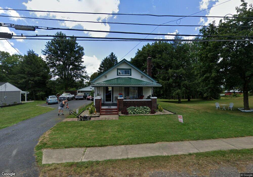
This home is located at 660 Wooster St, Lodi, OH 44254 and is currently estimated at $219,982, approximately $199 per square foot. 660 Wooster St is a home located in Medina County with nearby schools including Cloverleaf Elementary School, Cloverleaf Middle School, and Cloverleaf High School.
Ownership History
Date
Name
Owned For
Owner Type
Purchase Details
Closed on
Oct 1, 2024
Sold by
Osborn Carol
Bought by
Pritchard James and Osborn Carol
Current Estimated Value
Purchase Details
Closed on
Sep 21, 2018
Sold by
Ritenour Jennifer J and Ritenour Ronald
Bought by
Osborn Carol
Home Financials for this Owner
Home Financials are based on the most recent Mortgage that was taken out on this home.
Original Mortgage
$142,590
Interest Rate
4.5%
Mortgage Type
New Conventional
Purchase Details
Closed on
Dec 27, 2017
Sold by
Blair Ramona
Bought by
Ritenour Jennifer J
Create a Home Valuation Report for This Property
The Home Valuation Report is an in-depth analysis detailing your home's value as well as a comparison with similar homes in the area
Home Values in the Area
Average Home Value in this Area
Purchase History
| Date | Buyer | Sale Price | Title Company |
|---|---|---|---|
| Pritchard James | -- | None Listed On Document | |
| Osborn Carol | $157,000 | None Available | |
| Ritenour Jennifer J | $57,334 | None Available |
Source: Public Records
Mortgage History
| Date | Status | Borrower | Loan Amount |
|---|---|---|---|
| Previous Owner | Osborn Carol | $142,590 |
Source: Public Records
Tax History Compared to Growth
Tax History
| Year | Tax Paid | Tax Assessment Tax Assessment Total Assessment is a certain percentage of the fair market value that is determined by local assessors to be the total taxable value of land and additions on the property. | Land | Improvement |
|---|---|---|---|---|
| 2024 | $2,039 | $57,200 | $12,910 | $44,290 |
| 2023 | $2,039 | $57,200 | $12,910 | $44,290 |
| 2022 | $2,298 | $57,200 | $12,910 | $44,290 |
| 2021 | $2,105 | $48,470 | $10,940 | $37,530 |
| 2020 | $2,135 | $48,470 | $10,940 | $37,530 |
| 2019 | $2,144 | $48,470 | $10,940 | $37,530 |
| 2018 | $1,892 | $33,040 | $13,610 | $19,430 |
| 2017 | $1,393 | $33,040 | $13,610 | $19,430 |
| 2016 | $1,411 | $33,040 | $13,610 | $19,430 |
| 2015 | $1,391 | $32,070 | $13,210 | $18,860 |
| 2014 | $1,043 | $27,900 | $11,490 | $16,410 |
| 2013 | $848 | $25,370 | $10,940 | $14,430 |
Source: Public Records
Map
Nearby Homes
- 106 Anderson Cove Unit 206
- 0 Greenwich Rd Unit 5170888
- 221 N Market St
- 133 S Broadway St
- 125 Bank St
- 403 Young Dr
- 108 River St
- 720 Medina St
- 8123 Vandemark Rd
- 7595 Kings Creek Dr
- 0 Cemetery Rd
- 7908 Garman Rd
- 7680 Vandemark Rd
- 7660 Vandemark Rd
- 131 Mill St
- 7101 Greenwich Rd
- 7009 Greenwich Rd
- 9835 Congress Rd
- 6895 Grant Dr
- 0 Repp Rd
- 664 Wooster St
- 668 Wooster St
- 656 Wooster St
- 654 Wooster St
- 652 Wooster St
- 665 Wooster St
- 650 Wooster St
- 102 Anderson Cove
- 104 Anderson Cove
- 106 Anderson Cove
- 108 Anderson Cove
- 645 Wooster St
- 110 Anderson Cove
- 112 Anderson Cove
- 114 Anderson Cove
- 116 Anderson Cove Unit 17
- 111 Anderson Cove
- 113 Anderson Cove Unit 8
- 118 Anderson Cove Unit 16
- 115 Anderson Cove