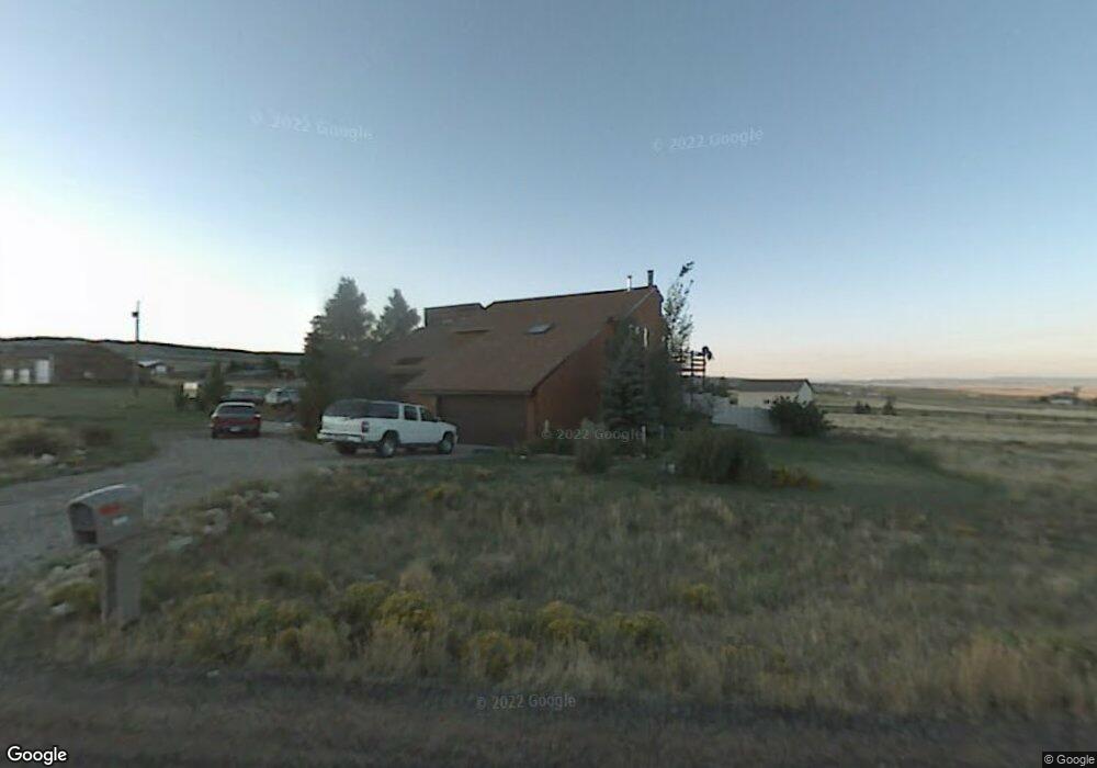
6600 Pilot Peak Rd Laramie, WY 82070
Estimated Value: $606,000 - $689,000
4
Beds
3
Baths
2,710
Sq Ft
$241/Sq Ft
Est. Value
About This Home
This home is located at 6600 Pilot Peak Rd, Laramie, WY 82070 and is currently estimated at $652,415, approximately $240 per square foot. 6600 Pilot Peak Rd is a home located in Albany County with nearby schools including Beitel Elementary School, Laramie Middle School, and Laramie High School.
Ownership History
Date
Name
Owned For
Owner Type
Purchase Details
Closed on
Jan 15, 2025
Sold by
Temsik Tara L
Bought by
Clark Grant W and Clark Ellen S
Current Estimated Value
Purchase Details
Closed on
Jul 21, 2020
Sold by
Reynolds Danny L and Reynolds Sherry L
Bought by
Reynolds Dan and Reynolds Sherry L
Home Financials for this Owner
Home Financials are based on the most recent Mortgage that was taken out on this home.
Original Mortgage
$202,900
Interest Rate
3.2%
Mortgage Type
New Conventional
Purchase Details
Closed on
Jun 8, 2006
Sold by
Schmidtmann Edward T and Schmidtmann Patricia Ann
Bought by
Reynolds Danny L and Reynolds Sherry L
Home Financials for this Owner
Home Financials are based on the most recent Mortgage that was taken out on this home.
Original Mortgage
$207,000
Interest Rate
6%
Mortgage Type
Adjustable Rate Mortgage/ARM
Create a Home Valuation Report for This Property
The Home Valuation Report is an in-depth analysis detailing your home's value as well as a comparison with similar homes in the area
Home Values in the Area
Average Home Value in this Area
Purchase History
| Date | Buyer | Sale Price | Title Company |
|---|---|---|---|
| Clark Grant W | -- | First American Title | |
| Clark Grant W | -- | First American Title | |
| Reynolds Dan | -- | None Available | |
| Reynolds Danny L | -- | First American Title | |
| Reynolds Danny L | -- | -- |
Source: Public Records
Mortgage History
| Date | Status | Borrower | Loan Amount |
|---|---|---|---|
| Previous Owner | Reynolds Danny L | $202,900 | |
| Previous Owner | Reynolds Danny L | $207,000 |
Source: Public Records
Tax History Compared to Growth
Tax History
| Year | Tax Paid | Tax Assessment Tax Assessment Total Assessment is a certain percentage of the fair market value that is determined by local assessors to be the total taxable value of land and additions on the property. | Land | Improvement |
|---|---|---|---|---|
| 2025 | $4,064 | $40,844 | $7,543 | $33,301 |
| 2024 | $4,064 | $51,963 | $9,670 | $42,293 |
| 2023 | $4,199 | $53,934 | $6,769 | $47,165 |
| 2022 | $3,647 | $46,844 | $6,769 | $40,075 |
| 2021 | $3,478 | $44,350 | $6,260 | $38,090 |
| 2020 | $3,302 | $41,766 | $6,260 | $35,506 |
| 2019 | $3,164 | $39,731 | $6,260 | $33,471 |
| 2018 | $3,032 | $38,411 | $6,353 | $32,058 |
| 2017 | $2,985 | $37,726 | $6,353 | $31,373 |
| 2016 | $3,048 | $38,648 | $6,658 | $31,990 |
| 2015 | $2,681 | $39,679 | $6,658 | $33,021 |
| 2014 | $2,681 | $39,421 | $0 | $0 |
Source: Public Records
Map
Nearby Homes
- TBD Sherman Hill Rd
- 3210 Evergreen Dr
- 1517 Shetland Dr
- 4609 Meadowlark Ln
- 1501 Arabian Dr
- 4746 E Skyline Dr Unit 31
- 4746 E Skyline Dr Unit 47
- 4500 E Meadowlark Ln Unit A
- 4328 Beech St Unit SR1
- 4328 Beech St Unit 7
- 4223 Moraine St
- 4141 Cliff St
- 4031 Cliff St
- 1702 Walsh Ct Unit C
- 1916 Peak Cir
- 4039 Bill Nye Ave
- 4037 Bill Nye Ave
- 429 Bill Nye Ave
- 4033 Bill Nye Ave
- 4029 Bill Nye Ave
- 6586 Pilot Peak Rd
- 6617 Black Elk Trail
- 9 Snowy View Rd
- 6747 Black Elk Trail
- 12 Snowy View Ct
- 6417 Mountain Mist Ct
- 6839 Black Elk Trail
- 6822 Black Elk Trail
- 6741 Black Elk Trail
- 6620 Pilot Peak Rd
- 6614 Pilot Peak Rd
- 6624 Pilot Peak Rd
- 6416 Mountain Mist Ct
- 2418 Crazy Horse Way
- 6342 Pilot Peak Rd
- 14 Snowy View Ct
- 6407 Windmill Ct
- 6926 Black Elk Trail
- 6315 Pilot Peak Rd
- 15 Snowy View Ct