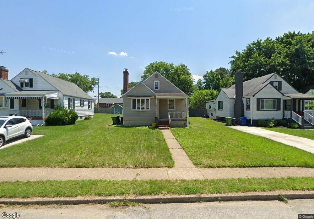
6607 Moyer Ave Baltimore, MD 21206
North Harford Road NeighborhoodEstimated Value: $232,000 - $260,819
3
Beds
1
Bath
1,353
Sq Ft
$182/Sq Ft
Est. Value
About This Home
This home is located at 6607 Moyer Ave, Baltimore, MD 21206 and is currently estimated at $246,410, approximately $182 per square foot. 6607 Moyer Ave is a home located in Baltimore City with nearby schools including Glenmount Elementary/Middle School, Booker T. Washington Middle School, and Paul Laurence Dunbar High School.
Ownership History
Date
Name
Owned For
Owner Type
Purchase Details
Closed on
Aug 4, 2022
Sold by
Buckner Kenneth J
Bought by
Moyer Ave Llc
Current Estimated Value
Purchase Details
Closed on
Oct 2, 2008
Sold by
Markel Holly J
Bought by
Markel Holly J and Buckner Kenneth J
Purchase Details
Closed on
Jan 18, 2007
Sold by
Smith Elizabeth R
Bought by
Markel Holly J
Home Financials for this Owner
Home Financials are based on the most recent Mortgage that was taken out on this home.
Original Mortgage
$179,075
Interest Rate
6.29%
Mortgage Type
Purchase Money Mortgage
Purchase Details
Closed on
May 16, 2005
Sold by
Yeager Ruth B
Bought by
Smith Elizabeth R
Create a Home Valuation Report for This Property
The Home Valuation Report is an in-depth analysis detailing your home's value as well as a comparison with similar homes in the area
Home Values in the Area
Average Home Value in this Area
Purchase History
We collect this data history from publicly available records. To have your information removed, we recommend requesting removal directly through your county’s website.
| Date | Buyer | Sale Price | Title Company |
|---|---|---|---|
| Moyer Ave Llc | $195,000 | -- | |
| Markel Holly J | -- | -- | |
| Markel Holly J | $188,500 | -- | |
| Smith Elizabeth R | $159,900 | -- |
Source: Public Records
Mortgage History
We collect this data history from publicly available records. To have your information removed, we recommend requesting removal directly through your county’s website.
| Date | Status | Borrower | Loan Amount |
|---|---|---|---|
| Previous Owner | Markel Holly J | $179,075 |
Source: Public Records
Tax History
| Year | Tax Paid | Tax Assessment Tax Assessment Total Assessment is a certain percentage of the fair market value that is determined by local assessors to be the total taxable value of land and additions on the property. | Land | Improvement |
|---|---|---|---|---|
| 2025 | $4,080 | $176,533 | -- | -- |
| 2024 | $4,080 | $173,700 | $52,100 | $121,600 |
| 2023 | $4,021 | $170,400 | $0 | $0 |
| 2022 | $3,607 | $167,100 | $0 | $0 |
| 2021 | $3,866 | $163,800 | $52,100 | $111,700 |
| 2020 | $3,421 | $158,367 | $0 | $0 |
| 2019 | $3,276 | $152,933 | $0 | $0 |
| 2018 | $3,243 | $147,500 | $52,100 | $95,400 |
| 2017 | $3,273 | $147,500 | $0 | $0 |
| 2016 | $3,436 | $147,500 | $0 | $0 |
| 2015 | $3,436 | $154,600 | $0 | $0 |
| 2014 | $3,436 | $154,600 | $0 | $0 |
Source: Public Records
Map
Nearby Homes
- 3302 E Northern Pkwy
- 3234 E Northern Pkwy
- 3202 E Northern Pkwy
- 3227 Woodring Ave
- 6506 Glenoak Ave
- 6303 Moyer Ave
- 3616 Bellevale Ave
- 6413 Glenoak Ave
- 3159 Woodring Ave
- 3045 Fleetwood Ave
- 3308 Westfield Ave
- 3304 Westfield Ave
- 6429 Walther Ave Unit F
- 3714 Mayberry Ave Unit A
- 3714 Mayberry Ave Unit F
- 6414 Fairdel Ave
- 3018 Northway Dr
- 3306 Orlando Ave
- 3421 Orlando Ave
- 3433 Orlando Ave
Your Personal Tour Guide
Ask me questions while you tour the home.