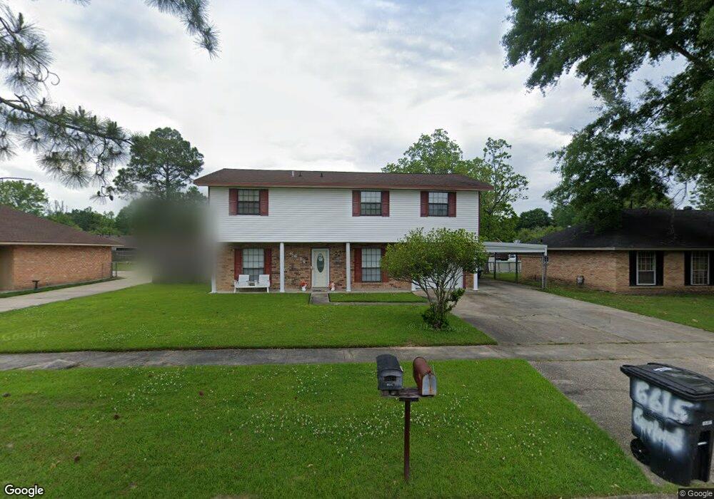
6615 Garland Ave Baker, LA 70714
Brownfields NeighborhoodEstimated Value: $213,000 - $228,000
4
Beds
3
Baths
1,934
Sq Ft
$114/Sq Ft
Est. Value
About This Home
This home is located at 6615 Garland Ave, Baker, LA 70714 and is currently estimated at $219,757, approximately $113 per square foot. 6615 Garland Ave is a home located in East Baton Rouge Parish with nearby schools including White Hills Elementary School, Northeast High School, and Impact Charter School.
Ownership History
Date
Name
Owned For
Owner Type
Purchase Details
Closed on
Jan 26, 2001
Sold by
Powers Janice Lorio Barrios
Bought by
Veal David and Veal Belinda
Current Estimated Value
Home Financials for this Owner
Home Financials are based on the most recent Mortgage that was taken out on this home.
Original Mortgage
$84,910
Outstanding Balance
$40,539
Interest Rate
11.5%
Estimated Equity
$179,218
Create a Home Valuation Report for This Property
The Home Valuation Report is an in-depth analysis detailing your home's value as well as a comparison with similar homes in the area
Home Values in the Area
Average Home Value in this Area
Purchase History
| Date | Buyer | Sale Price | Title Company |
|---|---|---|---|
| Veal David | $99,900 | -- |
Source: Public Records
Mortgage History
| Date | Status | Borrower | Loan Amount |
|---|---|---|---|
| Open | Veal David | $84,910 |
Source: Public Records
Tax History Compared to Growth
Tax History
| Year | Tax Paid | Tax Assessment Tax Assessment Total Assessment is a certain percentage of the fair market value that is determined by local assessors to be the total taxable value of land and additions on the property. | Land | Improvement |
|---|---|---|---|---|
| 2024 | $1,834 | $21,600 | $1,100 | $20,500 |
| 2023 | $1,842 | $18,200 | $1,100 | $17,100 |
| 2022 | $2,453 | $18,200 | $1,100 | $17,100 |
| 2021 | $2,413 | $18,200 | $1,100 | $17,100 |
| 2020 | $2,440 | $18,200 | $1,100 | $17,100 |
| 2019 | $1,909 | $13,700 | $1,100 | $12,600 |
| 2018 | $1,889 | $13,700 | $1,100 | $12,600 |
| 2017 | $1,889 | $13,700 | $1,100 | $12,600 |
| 2016 | $269 | $9,290 | $1,100 | $8,190 |
| 2015 | $492 | $11,200 | $1,100 | $10,100 |
| 2014 | $491 | $11,200 | $1,100 | $10,100 |
| 2013 | -- | $11,200 | $1,100 | $10,100 |
Source: Public Records
Map
Nearby Homes
- 6505 Stoneview Ave
- 13261 Plank Rd
- 13311 Plank Rd
- 13443 Plank Rd
- 16920 Plank Rd
- 7425 Comite Dr
- 12105 Foster Rd
- 6836 Yorkdale Ave
- 6525 Brownfields Dr
- 13841 Blairstown Dr
- 14137 Blairstown Dr
- 12265 Plank Rd
- 6466 Celia Ave
- 8724 Pettit Rd
- 11544 Ellen Dr
- 13420 Docile Ct
- 6834 Saint Mary Ave
- 12138 Lazy Oaks Dr
- 5885 Lavey Ln Unit 128
- 5885 Lavey Ln Unit 46
- 6625 Garland Ave
- 6605 Garland Ave
- 6605 Garland Ave
- 6626 Lebrent Ave
- 6553 Garland Ave
- 6636 Lebrent Ave
- 6616 Lebrent Ave
- 6614 Garland Ave
- 6554 Lebrent Ave
- 6604 Garland Ave
- 6624 Garland Ave
- 13018 Maleda Dr
- 6543 Garland Ave
- 13008 Maleda Dr
- 6552 Garland Ave
- 6552 Garland Ave
- 6706 Garland Ave
- 6544 Lebrent Ave
- 13028 Maleda Dr
- 6542 Garland Ave