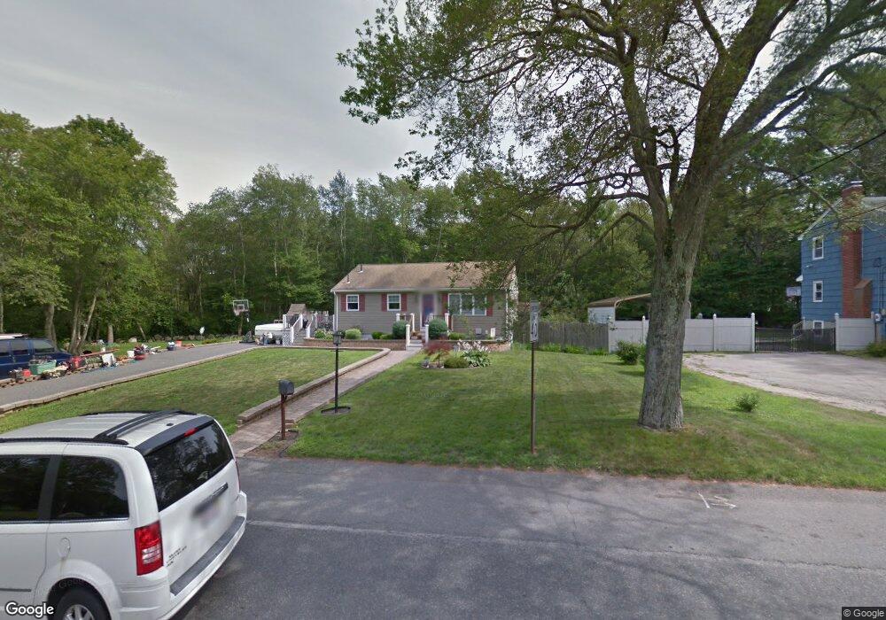
662 Auburn St Whitman, MA 02382
Estimated Value: $525,000 - $590,000
3
Beds
1
Bath
1,638
Sq Ft
$339/Sq Ft
Est. Value
About This Home
This home is located at 662 Auburn St, Whitman, MA 02382 and is currently estimated at $554,751, approximately $338 per square foot. 662 Auburn St is a home located in Plymouth County with nearby schools including Trinity Catholic Academy and Cardinal Spellman High School.
Ownership History
Date
Name
Owned For
Owner Type
Purchase Details
Closed on
Mar 24, 2006
Sold by
Nelson David L and Nelson Cheryl A
Bought by
Nelson Cheryl A
Current Estimated Value
Purchase Details
Closed on
Jul 31, 1995
Sold by
Morse Dennis G and Morse Diann R
Bought by
Nelson David L and Nelson Cheryl A
Purchase Details
Closed on
May 1, 1990
Sold by
Mckenzie Kenneth E
Bought by
Morse Dennis G
Create a Home Valuation Report for This Property
The Home Valuation Report is an in-depth analysis detailing your home's value as well as a comparison with similar homes in the area
Home Values in the Area
Average Home Value in this Area
Purchase History
| Date | Buyer | Sale Price | Title Company |
|---|---|---|---|
| Nelson Cheryl A | -- | -- | |
| Nelson David L | $100,000 | -- | |
| Morse Dennis G | $122,000 | -- |
Source: Public Records
Mortgage History
| Date | Status | Borrower | Loan Amount |
|---|---|---|---|
| Open | Morse Dennis G | $236,000 | |
| Closed | Morse Dennis G | $236,000 |
Source: Public Records
Tax History Compared to Growth
Tax History
| Year | Tax Paid | Tax Assessment Tax Assessment Total Assessment is a certain percentage of the fair market value that is determined by local assessors to be the total taxable value of land and additions on the property. | Land | Improvement |
|---|---|---|---|---|
| 2025 | $5,774 | $440,100 | $209,000 | $231,100 |
| 2024 | $6,220 | $488,200 | $204,700 | $283,500 |
| 2023 | $6,029 | $444,300 | $177,800 | $266,500 |
| 2022 | $5,891 | $404,600 | $162,700 | $241,900 |
| 2021 | $5,627 | $363,000 | $143,300 | $219,700 |
| 2020 | $4,858 | $306,500 | $143,300 | $163,200 |
| 2019 | $4,532 | $294,700 | $143,300 | $151,400 |
| 2018 | $4,393 | $274,400 | $135,800 | $138,600 |
| 2017 | $4,138 | $274,400 | $135,800 | $138,600 |
| 2016 | $3,709 | $237,900 | $118,500 | $119,400 |
| 2015 | $3,714 | $237,900 | $118,500 | $119,400 |
Source: Public Records
Map
Nearby Homes
- 728 Auburn St Unit F6
- 618 Auburn St
- 534 Hogg Memorial Dr
- 307 Homeland Dr
- 262 Homeland Dr
- 205 Bedford St
- 88 Woodlawn Cir
- 277 School St
- 604 Bedford St Unit 5
- 1121 Auburn St
- 24 Churchill Ave
- 70 Surrey Ln
- 70 Surrey Ln
- 848 N Bedford St Phase III
- 848 N Bedford St Phase IV
- 848 N
- 848 N Bedford St
- 150 Harvard St
- 8 Wild Turkey Ln
- 782 Bedford St
- 672 Auburn St
- 671 Auburn St
- 679 Auburn St
- 677 Auburn St
- 643 Auburn St
- 601 Hogg Memorial Dr
- 606 Hogg Memorial Dr
- 631 Auburn St
- 705 Auburn St
- 705 Auburn St Unit 705
- 705 Auburn St Unit 1
- 703 Auburn St
- 703 Auburn St Unit 2
- 591 Hogg Memorial Dr
- 596 Hogg Memorial Dr
- 22 Homeland Dr
- 628 Auburn St
- 588 Hogg Memorial Dr
- 725 Auburn St
- 24 Homeland Dr