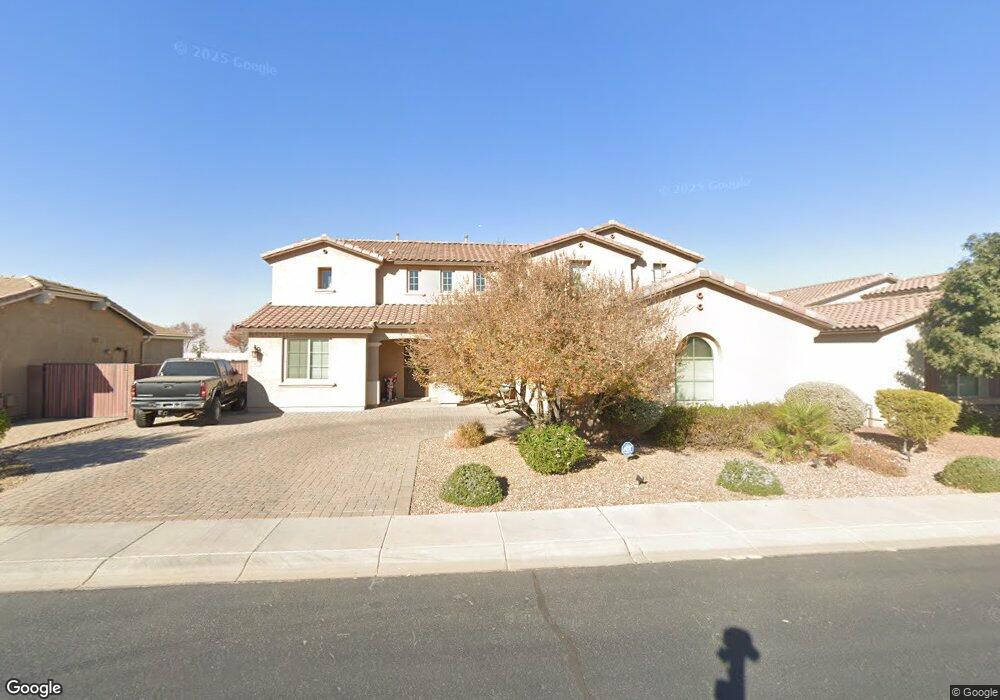
662 W Honey Locust Ave San Tan Valley, AZ 85140
Superstition Vistas NeighborhoodEstimated Value: $651,749 - $716,000
--
Bed
--
Bath
4,134
Sq Ft
$165/Sq Ft
Est. Value
About This Home
This home is located at 662 W Honey Locust Ave, San Tan Valley, AZ 85140 and is currently estimated at $681,687, approximately $164 per square foot. 662 W Honey Locust Ave is a home with nearby schools including Ranch Elementary School, J. O. Combs Middle School, and Legacy Traditional School - Queen Creek.
Ownership History
Date
Name
Owned For
Owner Type
Purchase Details
Closed on
Aug 15, 2017
Sold by
Reed Duna D
Bought by
Reed Byron
Current Estimated Value
Home Financials for this Owner
Home Financials are based on the most recent Mortgage that was taken out on this home.
Original Mortgage
$361,642
Outstanding Balance
$302,330
Interest Rate
4.03%
Mortgage Type
New Conventional
Estimated Equity
$379,357
Create a Home Valuation Report for This Property
The Home Valuation Report is an in-depth analysis detailing your home's value as well as a comparison with similar homes in the area
Home Values in the Area
Average Home Value in this Area
Purchase History
| Date | Buyer | Sale Price | Title Company |
|---|---|---|---|
| Reed Byron | -- | None Available | |
| Reed Brron | $401,825 | Security Title Agency Inc | |
| Fulton Homes Sales Corporation | $133,767 | Security Title Agency Inc |
Source: Public Records
Mortgage History
| Date | Status | Borrower | Loan Amount |
|---|---|---|---|
| Open | Reed Byron | $361,642 |
Source: Public Records
Tax History Compared to Growth
Tax History
| Year | Tax Paid | Tax Assessment Tax Assessment Total Assessment is a certain percentage of the fair market value that is determined by local assessors to be the total taxable value of land and additions on the property. | Land | Improvement |
|---|---|---|---|---|
| 2025 | $2,947 | $60,210 | -- | -- |
| 2024 | $2,965 | $68,764 | -- | -- |
| 2023 | $2,935 | $57,145 | $7,875 | $49,270 |
| 2022 | $2,965 | $39,082 | $5,250 | $33,832 |
| 2021 | $2,999 | $35,217 | $0 | $0 |
| 2020 | $2,920 | $32,061 | $0 | $0 |
| 2019 | $2,781 | $28,711 | $0 | $0 |
| 2018 | $2,307 | $4,800 | $0 | $0 |
| 2017 | $452 | $4,800 | $0 | $0 |
| 2016 | $397 | $4,800 | $4,800 | $0 |
Source: Public Records
Map
Nearby Homes
- 683 W Honey Locust Ave
- 726 W Tallow Tree Ave
- 684 W Coffee Tree Ave
- 489 W Flame Tree Ave
- 809 W Tallow Tree Ave
- 42214 N Ambrosio Dr
- 42247 Tulip Tree St
- 42175 N Wollemi St
- 42168 N Fern Leaf St
- 472 W Dragon Tree Ave
- 873 Sisso Tree Ave
- 62 W Hackberry Ave
- 328 W Dragon Tree Ave
- 65 W Cucumber Tree Ave
- 199 W Reeves Ave
- 386 W Lyle Ave
- 652 W Mangrove Rd
- 374 W Lyle Ave
- 1082 W Layland Ave
- 360 W Lyle Ave
- 640 W Honey Locust Ave
- 682 W Honey Locust Ave
- 618 W Honey Locust Ave
- 702 W Honey Locust Ave
- 665 W Honey Locust Ave
- 42227 N Myrtle St
- 703 W Honey Locust Ave
- 722 W Honey Locust Ave
- 42207 N Myrtle St
- 725 W Honey Locust Ave
- 742 W Honey Locust Ave
- 666 W Tallow Tree Ave
- 684 W Tallow Tree Ave
- 566 W Honey Locust Ave
- 706 W Tallow Tree Ave
- 745 W Honey Locust Ave
- 42185 N Myrtle St
- 42190 N Tupelo St
- 552 W Honey Locust Ave
- 762 W Honey Locust Ave