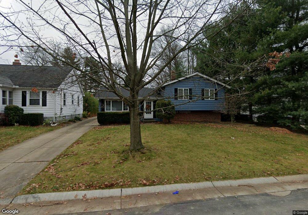
6620 Daisy Ave Independence, OH 44131
Estimated Value: $273,000 - $383,000
4
Beds
2
Baths
1,840
Sq Ft
$171/Sq Ft
Est. Value
About This Home
This home is located at 6620 Daisy Ave, Independence, OH 44131 and is currently estimated at $314,998, approximately $171 per square foot. 6620 Daisy Ave is a home located in Cuyahoga County with nearby schools including Independence Primary School, Independence Middle School, and Independence High School.
Ownership History
Date
Name
Owned For
Owner Type
Purchase Details
Closed on
Mar 4, 1993
Sold by
Leibold Robert A
Bought by
Kula Kenneth G
Current Estimated Value
Purchase Details
Closed on
Feb 22, 1988
Sold by
Dennis J Ostrowski
Bought by
Leibold Robert A
Purchase Details
Closed on
Mar 26, 1981
Sold by
Ostrowski Dennis J
Bought by
Dennis J Ostrowski
Purchase Details
Closed on
Mar 9, 1977
Sold by
Ostrowski Felix A
Bought by
Ostrowski Dennis J
Purchase Details
Closed on
Nov 21, 1975
Sold by
Lesh Roger J and Lesh Ruth E
Bought by
Lesh Ruth E
Purchase Details
Closed on
Jan 1, 1975
Bought by
Lesh Roger J and Lesh Ruth E
Create a Home Valuation Report for This Property
The Home Valuation Report is an in-depth analysis detailing your home's value as well as a comparison with similar homes in the area
Home Values in the Area
Average Home Value in this Area
Purchase History
We collect this data history from publicly available records. To have your information removed, we recommend requesting removal directly through your county’s website.
| Date | Buyer | Sale Price | Title Company |
|---|---|---|---|
| Kula Kenneth G | $127,500 | -- | |
| Leibold Robert A | $95,000 | -- | |
| Dennis J Ostrowski | -- | -- | |
| Ostrowski Dennis J | -- | -- | |
| Ostrowski Felix A | $51,200 | -- | |
| Lesh Ruth E | -- | -- | |
| Lesh Roger J | -- | -- |
Source: Public Records
Tax History
| Year | Tax Paid | Tax Assessment Tax Assessment Total Assessment is a certain percentage of the fair market value that is determined by local assessors to be the total taxable value of land and additions on the property. | Land | Improvement |
|---|---|---|---|---|
| 2025 | $4,623 | $100,135 | $13,895 | $86,240 |
| 2024 | $4,789 | $100,135 | $13,895 | $86,240 |
| 2023 | $4,062 | $77,180 | $13,130 | $64,050 |
| 2022 | $4,040 | $77,180 | $13,130 | $64,050 |
| 2021 | $3,981 | $77,180 | $13,130 | $64,050 |
| 2020 | $3,893 | $70,810 | $12,040 | $58,770 |
| 2019 | $3,758 | $202,300 | $34,400 | $167,900 |
| 2018 | $3,520 | $70,810 | $12,040 | $58,770 |
| 2017 | $3,316 | $59,680 | $9,030 | $50,650 |
| 2016 | $3,282 | $59,680 | $9,030 | $50,650 |
| 2015 | $3,280 | $59,680 | $9,030 | $50,650 |
| 2014 | $3,280 | $59,680 | $9,030 | $50,650 |
Source: Public Records
Map
Nearby Homes
- 6294 Chestnut Rd
- 0 Brecksville Rd
- 5815 Chestnut Rd
- 6325 Brecksville Rd
- 0 Daisy Blvd
- 0 Acorn Dr Unit 5023848
- 6663 Donna Rae Dr
- 6402 Dora Blvd
- 6208 Dora Blvd
- 6344 Gale Dr
- 6650 Parkgate Oval
- 3181 Parmalee Dr
- 6811 Drexel Dr
- 6210 Crossview Rd
- 6949 N Renwood Rd
- VL Laura Lee Ln
- 6968 Carol Dr
- VL TBB Laura Lee Ln
- 5706 Heinton Rd
- 4089 Fox Chase
- 6706 Daisy Ave
- 6600 Daisy Ave
- 6710 Daisy Ave
- 6714 Daisy Ave
- 6500 Anderson Ave
- 6701 Daisy Ave
- 6701 Daisy Ave
- 6718 Daisy Ave
- 6770 Daisy Ave
- 6508 Anderson Ave
- 6611 Chestnut Rd
- 6711 Daisy Ave
- 6516 Anderson Ave
- 6615 Chestnut Rd
- 6715 Daisy Ave
- 6812 Daisy Ave
- 6615 Daisy Ave
- 6521 Chestnut Rd
- 6816 Daisy Ave
- 6517 Chestnut Rd
Your Personal Tour Guide
Ask me questions while you tour the home.