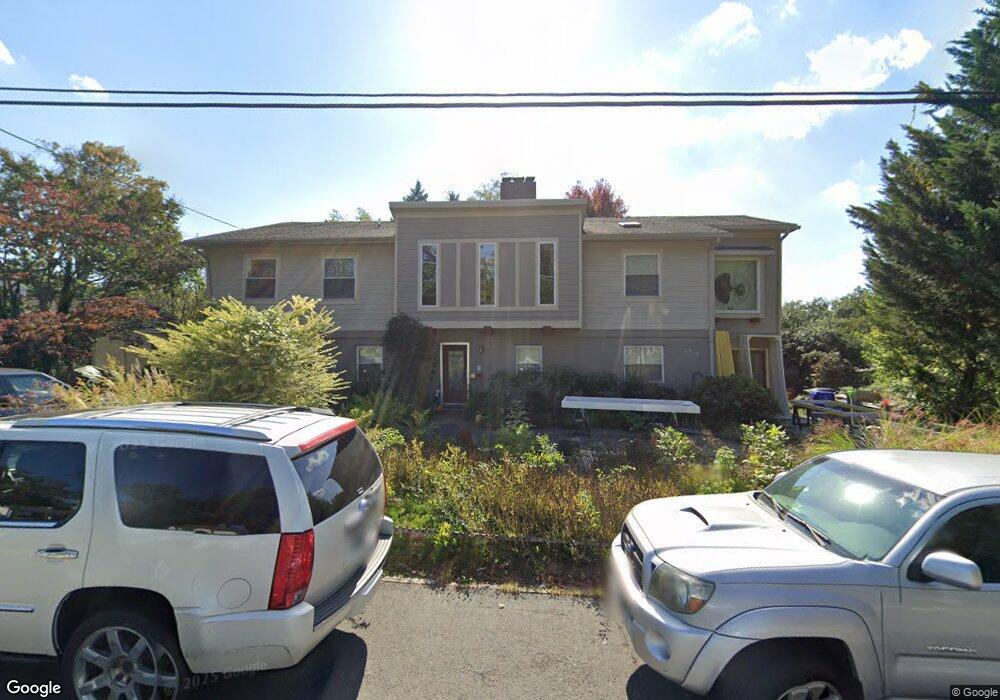
6620 Rannoch Rd Bethesda, MD 20817
Bannockburn NeighborhoodEstimated Value: $1,841,000 - $2,608,000
6
Beds
5
Baths
5,336
Sq Ft
$399/Sq Ft
Est. Value
About This Home
This home is located at 6620 Rannoch Rd, Bethesda, MD 20817 and is currently estimated at $2,128,446, approximately $398 per square foot. 6620 Rannoch Rd is a home located in Montgomery County with nearby schools including Bannockburn Elementary School, Marion Elementary School, and Lincoln Brick Elementary School.
Ownership History
Date
Name
Owned For
Owner Type
Purchase Details
Closed on
Sep 14, 2009
Sold by
Hilburn Melvin A
Bought by
Jaconi Michelle T and Hawe Bartholomew J
Current Estimated Value
Purchase Details
Closed on
Jun 5, 2003
Sold by
Perna Frank A
Bought by
Hilburn Melvin A and Hilburn Susan Ladani
Purchase Details
Closed on
Mar 3, 2003
Sold by
Cardoso Alaur and Cardoso Marina M
Bought by
Perna Frank A
Purchase Details
Closed on
Sep 3, 2002
Sold by
Neves Zeuxis F and Neves M E
Bought by
Cardoso Alaur and Cardoso Marina Mallouk
Create a Home Valuation Report for This Property
The Home Valuation Report is an in-depth analysis detailing your home's value as well as a comparison with similar homes in the area
Home Values in the Area
Average Home Value in this Area
Purchase History
| Date | Buyer | Sale Price | Title Company |
|---|---|---|---|
| Jaconi Michelle T | $1,160,000 | -- | |
| Hilburn Melvin A | $549,900 | -- | |
| Perna Frank A | $350,000 | -- | |
| Cardoso Alaur | -- | -- |
Source: Public Records
Tax History Compared to Growth
Tax History
| Year | Tax Paid | Tax Assessment Tax Assessment Total Assessment is a certain percentage of the fair market value that is determined by local assessors to be the total taxable value of land and additions on the property. | Land | Improvement |
|---|---|---|---|---|
| 2025 | $17,927 | $1,646,200 | $666,100 | $980,100 |
| 2024 | $17,927 | $1,481,867 | $0 | $0 |
| 2023 | $14,753 | $1,317,533 | $0 | $0 |
| 2022 | $12,806 | $1,153,200 | $605,600 | $547,600 |
| 2021 | $12,450 | $1,142,233 | $0 | $0 |
| 2020 | $12,450 | $1,131,267 | $0 | $0 |
| 2019 | $12,286 | $1,120,300 | $550,500 | $569,800 |
| 2018 | $12,278 | $1,120,300 | $550,500 | $569,800 |
| 2017 | $12,492 | $1,120,300 | $0 | $0 |
| 2016 | $10,306 | $1,155,700 | $0 | $0 |
| 2015 | $10,306 | $1,098,967 | $0 | $0 |
| 2014 | $10,306 | $1,042,233 | $0 | $0 |
Source: Public Records
Map
Nearby Homes
- 6705 Goldsboro Rd
- 3 Bay Tree Ln
- 5651 Bent Branch Rd
- 6518 Elgin Ln
- 6570 Fallwind Ln
- 6540 Wiscasset Rd
- 5400 Mohican Rd
- 6825 Laverock Ct
- 5420 Mohican Rd
- 7301 Bannockburn Ridge Ct
- 7115 Crail Dr
- 6700 Landon Ln
- 6204 Lenox Rd
- 6916 Carmichael Ave
- 7108 Broxburn Dr
- 5811 Ridgefield Rd
- 6813 Millwood Rd
- 5129 Wissioming Rd
- 6402 Orchid Dr
- 7400 Nevis Rd
- 6624 Rannoch Rd
- 6616 Rannoch Rd
- 6011 Cairn Terrace
- 6015 Cairn Terrace
- 6017 Cairn Terrace
- 6009 Cairn Terrace
- 6612 Rannoch Rd
- 6021 Cairn Terrace
- 6628 Rannoch Rd
- 6619 Rannoch Rd
- 6615 Rannoch Rd
- 6007 Cairn Terrace
- 6623 Rannoch Rd
- 6611 Rannoch Rd
- 6610 Rannoch Rd
- 6005 Cairn Terrace
- 6607 Rannoch Rd
- 6701 Goldsboro Rd
- 6004 Cairn Terrace
- 6314 Kenhowe Dr