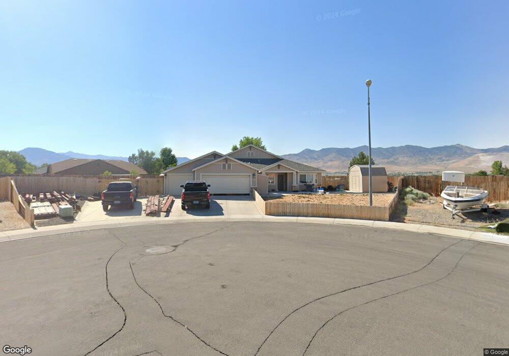
663 Buckskin Rd Dayton, NV 89403
Estimated Value: $575,462 - $632,000
5
Beds
3
Baths
2,770
Sq Ft
$221/Sq Ft
Est. Value
About This Home
This home is located at 663 Buckskin Rd, Dayton, NV 89403 and is currently estimated at $612,116, approximately $220 per square foot. 663 Buckskin Rd is a home located in Lyon County with nearby schools including Riverview Elementary School, Dayton Intermediate School, and Dayton High School.
Ownership History
Date
Name
Owned For
Owner Type
Purchase Details
Closed on
Mar 16, 2022
Sold by
Ramos Peter J and Ramos Dominique R
Bought by
Ramos Family Revocable Living Trust
Current Estimated Value
Purchase Details
Closed on
Sep 24, 2008
Sold by
Lennar Reno Llc
Bought by
Ramos Peter J and Ramos Doninique R
Home Financials for this Owner
Home Financials are based on the most recent Mortgage that was taken out on this home.
Original Mortgage
$297,950
Interest Rate
6.49%
Mortgage Type
VA
Create a Home Valuation Report for This Property
The Home Valuation Report is an in-depth analysis detailing your home's value as well as a comparison with similar homes in the area
Home Values in the Area
Average Home Value in this Area
Purchase History
| Date | Buyer | Sale Price | Title Company |
|---|---|---|---|
| Ramos Family Revocable Living Trust | -- | None Listed On Document | |
| Ramos Peter J | $297,950 | North American Title Company |
Source: Public Records
Mortgage History
| Date | Status | Borrower | Loan Amount |
|---|---|---|---|
| Previous Owner | Ramos Peter J | $297,950 |
Source: Public Records
Tax History Compared to Growth
Tax History
| Year | Tax Paid | Tax Assessment Tax Assessment Total Assessment is a certain percentage of the fair market value that is determined by local assessors to be the total taxable value of land and additions on the property. | Land | Improvement |
|---|---|---|---|---|
| 2025 | $3,156 | $165,539 | $52,500 | $113,039 |
| 2024 | $3,064 | $165,866 | $52,500 | $113,366 |
| 2023 | $3,064 | $158,358 | $52,500 | $105,858 |
| 2022 | $2,534 | $143,548 | $45,270 | $98,278 |
| 2021 | $2,461 | $136,849 | $41,160 | $95,689 |
| 2020 | $2,388 | $131,941 | $41,160 | $90,781 |
| 2019 | $2,319 | $114,694 | $27,040 | $87,654 |
| 2018 | $2,251 | $103,303 | $18,030 | $85,273 |
| 2017 | $2,186 | $94,606 | $9,450 | $85,156 |
| 2016 | $2,130 | $84,209 | $6,300 | $77,909 |
| 2015 | $2,126 | $70,448 | $6,300 | $64,148 |
| 2014 | $2,064 | $64,670 | $6,300 | $58,370 |
Source: Public Records
Map
Nearby Homes
- 677 Teakwood Rd
- 26 Kelsey Ct
- 36 Kelsey Ct
- 917 Saltbrush Rd
- 915 Saltbrush Rd
- 103 Rio Grande Way
- 306 Valley Vista Dr
- 131 Mcgill Ct
- 1145 Cheatgrass Dr
- 606 Occidental Dr
- 1232 Stratton Dr
- 1440 Riverpark Pkwy
- 125 Oakmont Dr
- 1122 Ferretto Pkwy
- 1498 Riverpark Pkwy
- 20 Cedar Crest Ct
- 19 Sandefer Ln
- 813 Camp Station Dr Unit Homesite 303
- 817 Camp Station Dr Unit Homesite 304
- 815 Camp Station Dr Unit Homesite 303
- 762 Lipizzan Rd
- 764 Lipizzan Rd
- 661 Buckskin Rd
- 664 Teakwood Rd
- 760 Lipizzan Rd
- 668 Teakwood Rd
- 659 Buckskin Rd
- 665 Teakwood Rd
- 758 Lipizzan Rd
- 763 Lipizzan Rd
- 669 Teakwood Rd
- 761 Lipizzan Rd
- 670 Teakwood Rd Unit 12
- 756 Lipizzan Rd
- 657 Buckskin Rd
- 724 Clydesdale Rd
- 671 Teakwood Rd
- 864 Klien St
- 862 Klien St
- 672 Teakwood Rd