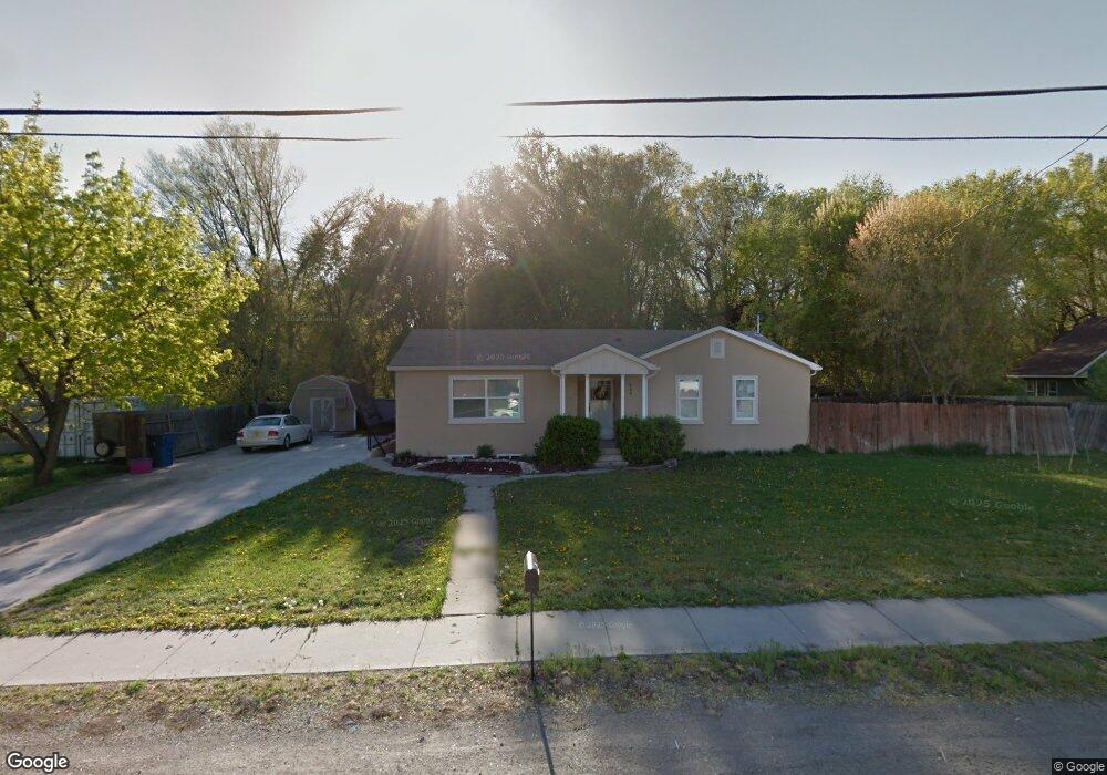
663 N 200 E American Fork, UT 84003
Estimated Value: $121,000 - $135,488
2
Beds
1
Bath
580
Sq Ft
$221/Sq Ft
Est. Value
About This Home
This home is located at 663 N 200 E, American Fork, UT 84003 and is currently estimated at $128,244, approximately $221 per square foot. 663 N 200 E is a home located in Utah County with nearby schools including Forbes Elementary School, American Fork Junior High School, and American Fork High School.
Ownership History
Date
Name
Owned For
Owner Type
Purchase Details
Closed on
Feb 13, 2024
Sold by
Bringhurst Michael
Bought by
Bluemountain Inc
Current Estimated Value
Purchase Details
Closed on
Oct 21, 2020
Sold by
Rausett Travis Kae
Bought by
Bluemount Inc
Home Financials for this Owner
Home Financials are based on the most recent Mortgage that was taken out on this home.
Original Mortgage
$197,000
Interest Rate
2.8%
Mortgage Type
Commercial
Purchase Details
Closed on
Oct 28, 2019
Sold by
Grant Lewis Colin and Grant June Lorraine
Bought by
Fausett Travis Kae
Purchase Details
Closed on
Nov 12, 2010
Sold by
Humpherys Betty L and Warfield Betty L
Bought by
Warfield Betty Lowe and The Betty Humpherys Family Trust
Create a Home Valuation Report for This Property
The Home Valuation Report is an in-depth analysis detailing your home's value as well as a comparison with similar homes in the area
Home Values in the Area
Average Home Value in this Area
Purchase History
| Date | Buyer | Sale Price | Title Company |
|---|---|---|---|
| Bluemountain Inc | $100,000 | None Listed On Document | |
| Bluemount Inc | -- | Capstone T&E Inc | |
| Fausett Travis Kae | -- | Vanguard Title Ins Agcy Llc | |
| Warfield Betty Lowe | -- | None Available |
Source: Public Records
Mortgage History
| Date | Status | Borrower | Loan Amount |
|---|---|---|---|
| Previous Owner | Bluemount Inc | $197,000 |
Source: Public Records
Tax History
| Year | Tax Paid | Tax Assessment Tax Assessment Total Assessment is a certain percentage of the fair market value that is determined by local assessors to be the total taxable value of land and additions on the property. | Land | Improvement |
|---|---|---|---|---|
| 2025 | $371 | $35,900 | $34,900 | $1,000 |
| 2024 | $371 | $173,745 | $0 | $0 |
| 2023 | $1,466 | $172,700 | $0 | $0 |
| 2022 | $1,588 | $184,635 | $0 | $0 |
| 2021 | $1,232 | $223,700 | $144,500 | $79,200 |
| 2020 | $1,141 | $201,000 | $129,000 | $72,000 |
| 2019 | $1,012 | $184,400 | $121,800 | $62,600 |
| 2018 | $930 | $161,900 | $107,500 | $54,400 |
| 2017 | $847 | $79,640 | $0 | $0 |
| 2016 | $790 | $68,970 | $0 | $0 |
| 2015 | $832 | $68,970 | $0 | $0 |
| 2014 | $795 | $65,010 | $0 | $0 |
Source: Public Records
Map
Nearby Homes
- 788 N 150 E Unit 3
- 807 N 150 E
- 783 N 150 E
- 793 N 150 E
- 780 N 100 E
- 822 N 150 E Unit 5
- 610 N 300 E
- 183 E 760 St N
- 894 N 60 E
- 4650 W Magnolia Drive Dr Unit 8
- 10238 N 6530 W Unit 15
- 5277 N 11200 W Unit 4
- 5284 N 11200 W Unit 3
- 6079 W Whisper Ln Unit 404
- 1220 E 700 N
- 6111 W Whisper Ln Unit 402
- 603 S 370 E
- 234 W 1080 N
- 621 N 100 W
- 474 E 580 N
Your Personal Tour Guide
Ask me questions while you tour the home.