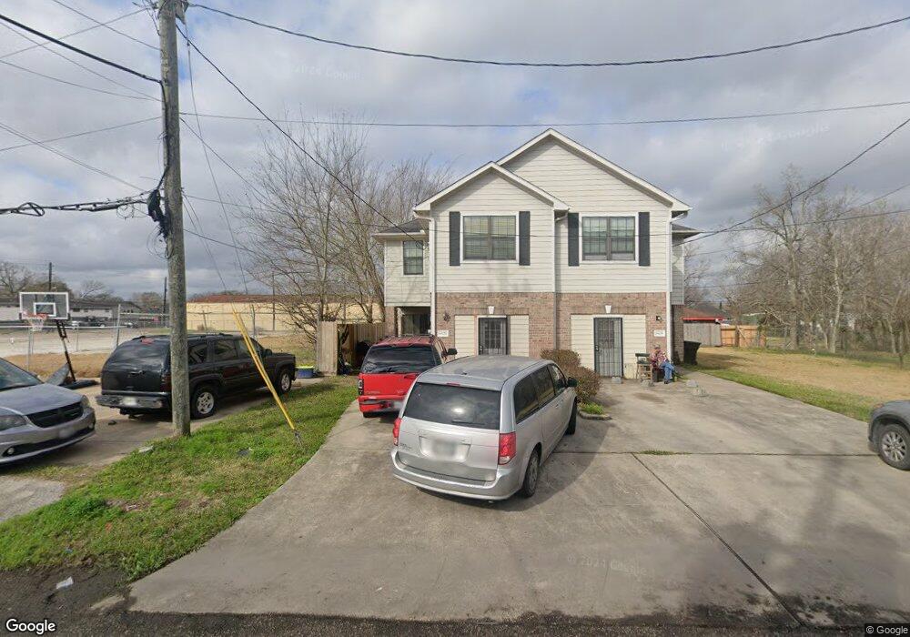
6630 Liverpool St Houston, TX 77021
OST-South Union NeighborhoodEstimated Value: $261,978 - $324,000
3
Beds
3
Baths
1,533
Sq Ft
$199/Sq Ft
Est. Value
About This Home
This home is located at 6630 Liverpool St, Houston, TX 77021 and is currently estimated at $305,245, approximately $199 per square foot. 6630 Liverpool St is a home located in Harris County with nearby schools including Hartsfield Elementary Animal and Environmental Sciences Magnet, Cullen Middle School, and Yates High School.
Ownership History
Date
Name
Owned For
Owner Type
Purchase Details
Closed on
Sep 6, 2012
Sold by
Calwell Quincy
Bought by
Jones Jimmy M and Jones Carolyn
Current Estimated Value
Purchase Details
Closed on
Aug 6, 2010
Sold by
Jones Jimmy M and Jones Carolyn
Bought by
Caldwell Quincy
Home Financials for this Owner
Home Financials are based on the most recent Mortgage that was taken out on this home.
Original Mortgage
$94,500
Interest Rate
4.54%
Mortgage Type
Seller Take Back
Create a Home Valuation Report for This Property
The Home Valuation Report is an in-depth analysis detailing your home's value as well as a comparison with similar homes in the area
Home Values in the Area
Average Home Value in this Area
Purchase History
| Date | Buyer | Sale Price | Title Company |
|---|---|---|---|
| Jones Jimmy M | -- | None Available | |
| Caldwell Quincy | -- | American Title Co Dp |
Source: Public Records
Mortgage History
| Date | Status | Borrower | Loan Amount |
|---|---|---|---|
| Previous Owner | Caldwell Quincy | $94,500 |
Source: Public Records
Tax History Compared to Growth
Tax History
| Year | Tax Paid | Tax Assessment Tax Assessment Total Assessment is a certain percentage of the fair market value that is determined by local assessors to be the total taxable value of land and additions on the property. | Land | Improvement |
|---|---|---|---|---|
| 2025 | $5,707 | $254,284 | $63,750 | $190,534 |
| 2024 | $5,707 | $272,771 | $63,750 | $209,021 |
| 2023 | $5,707 | $273,293 | $58,125 | $215,168 |
| 2022 | $4,936 | $224,170 | $52,500 | $171,670 |
| 2021 | $4,351 | $186,689 | $31,875 | $154,814 |
| 2020 | $4,050 | $167,254 | $20,625 | $146,629 |
| 2019 | $4,311 | $170,377 | $20,625 | $149,752 |
| 2018 | $2,789 | $110,225 | $16,875 | $93,350 |
| 2017 | $2,787 | $110,225 | $16,875 | $93,350 |
| 2016 | $2,787 | $110,225 | $16,875 | $93,350 |
| 2015 | $2,599 | $110,225 | $16,875 | $93,350 |
| 2014 | $2,599 | $101,114 | $9,375 | $91,739 |
Source: Public Records
Map
Nearby Homes
- 6438 Calhoun Rd
- 6714 Dumble St
- 6726 Dumble St Unit A/B
- 6637 New York St
- 6431 Paris St
- 6427 Paris St
- 6422 Calhoun Rd
- 6911 Madrid St
- 6423 Paris St
- 6418 Calhoun Rd
- 6531 London St
- 6636 New York St
- 6418 Paris St
- 6747 Liverpool St
- 6518 Weston St Unit 10
- 6614 London St Unit 12
- 6434 New York St
- 6710 New York St
- 6726 Paris St Unit A-B
- 6730 Paris St Unit A/B
- 6628 Liverpool St
- 0 Liverpool
- 6625 Liverpool St Unit 4
- 4721 Yellowstone Blvd
- 6619 Calhoun Rd
- 6945 Liverpool St
- 6402 Liverpool St
- 6746 Liverpool St
- 6626 Calhoun Rd
- 000 Liverpool & Dumble
- 6605 Calhoun Rd
- 6618 Dumble St
- 6622 Dumble St
- 6618 Calhoun Rd
- 6602 Dumble St
- 6614 Dumble St
- 6610 Dumble St
- 6623 Paris St
- 6619 Paris St
- 6726 Dumble St