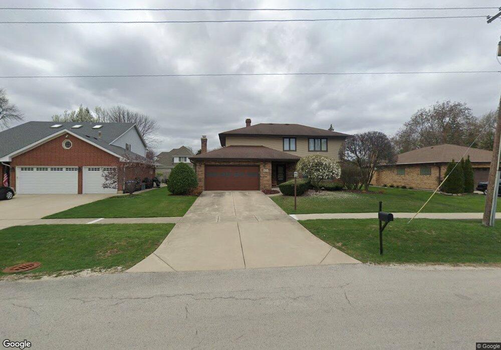
6636 Western Ave Willowbrook, IL 60527
Estimated Value: $478,941 - $757,000
Studio
1
Bath
2,746
Sq Ft
$233/Sq Ft
Est. Value
About This Home
This home is located at 6636 Western Ave, Willowbrook, IL 60527 and is currently estimated at $640,235, approximately $233 per square foot. 6636 Western Ave is a home located in DuPage County with nearby schools including Holmes Elementary School, Maercker Elementary School, and Westview Hills Middle School.
Ownership History
Date
Name
Owned For
Owner Type
Purchase Details
Closed on
Jul 1, 2013
Sold by
Leban Theodore Wiilliam and Leban Cynthia Jean
Bought by
Leban Theodore W and Leban Cynthia J
Current Estimated Value
Purchase Details
Closed on
May 3, 2002
Sold by
The Ryland Group Inc
Bought by
Malamis Dean G
Home Financials for this Owner
Home Financials are based on the most recent Mortgage that was taken out on this home.
Original Mortgage
$172,195
Interest Rate
6.38%
Mortgage Type
Purchase Money Mortgage
Create a Home Valuation Report for This Property
The Home Valuation Report is an in-depth analysis detailing your home's value as well as a comparison with similar homes in the area
Home Values in the Area
Average Home Value in this Area
Purchase History
| Date | Buyer | Sale Price | Title Company |
|---|---|---|---|
| Leban Theodore W | -- | None Available | |
| Malamis Dean G | $215,500 | -- |
Source: Public Records
Mortgage History
| Date | Status | Borrower | Loan Amount |
|---|---|---|---|
| Previous Owner | Malamis Dean G | $172,195 |
Source: Public Records
Tax History
| Year | Tax Paid | Tax Assessment Tax Assessment Total Assessment is a certain percentage of the fair market value that is determined by local assessors to be the total taxable value of land and additions on the property. | Land | Improvement |
|---|---|---|---|---|
| 2024 | $7,347 | $129,895 | $56,827 | $73,068 |
| 2023 | $7,032 | $119,410 | $52,240 | $67,170 |
| 2022 | $7,320 | $119,630 | $51,160 | $68,470 |
| 2021 | $6,691 | $118,270 | $50,580 | $67,690 |
| 2020 | $6,936 | $115,930 | $49,580 | $66,350 |
| 2019 | $6,691 | $111,230 | $47,570 | $63,660 |
| 2018 | $7,131 | $118,610 | $47,330 | $71,280 |
| 2017 | $6,861 | $114,130 | $45,540 | $68,590 |
| 2016 | $6,676 | $108,920 | $43,460 | $65,460 |
| 2015 | $6,571 | $102,480 | $40,890 | $61,590 |
| 2014 | $7,450 | $114,610 | $39,760 | $74,850 |
| 2013 | $7,235 | $114,070 | $39,570 | $74,500 |
Source: Public Records
Map
Nearby Homes
- 6136 Bentley Ave
- 1061 Sean Cir
- 6808 Scotch Pine Trail
- 6503 Clarendon Hills Rd
- 1109 Ponderosa Ct
- 335 63rd St
- 6925 Clarendon Hills Rd
- 1117 Bristlecone Ct
- 1156 Bristlecone Ct
- 601 Lake Hinsdale Dr Unit 101
- 601 Lake Hinsdale Dr Unit 112
- 601 Lake Hinsdale Dr Unit 301
- 6425 Clarendon Hills Rd Unit 211
- 301 Lake Hinsdale Dr Unit 108
- 301 Lake Hinsdale Dr Unit 311
- 301 Lake Hinsdale Dr Unit 404
- 701 Lake Hinsdale Dr Unit 306
- 19 Portwine Rd
- 6106 Western Ave
- 200 Brookside Ln Unit A
- 6632 Western Ave
- 6640 Western Ave
- 708 67th St
- 6628 Western Ave
- 712 67th St
- 454 67th St
- 6620 Western Ave
- 6702 Western Ave
- 716 67th St
- 6617 Western Ave
- 6701 Leonard Dr
- 6612 Western Ave
- 720 67th St
- 6613 Western Ave
- 450 67th St
- 6606 Western Ave
- 6706 Western Ave
- 6705 Leonard Dr
- 6607 Western Ave
- 724 67th St
Your Personal Tour Guide
Ask me questions while you tour the home.