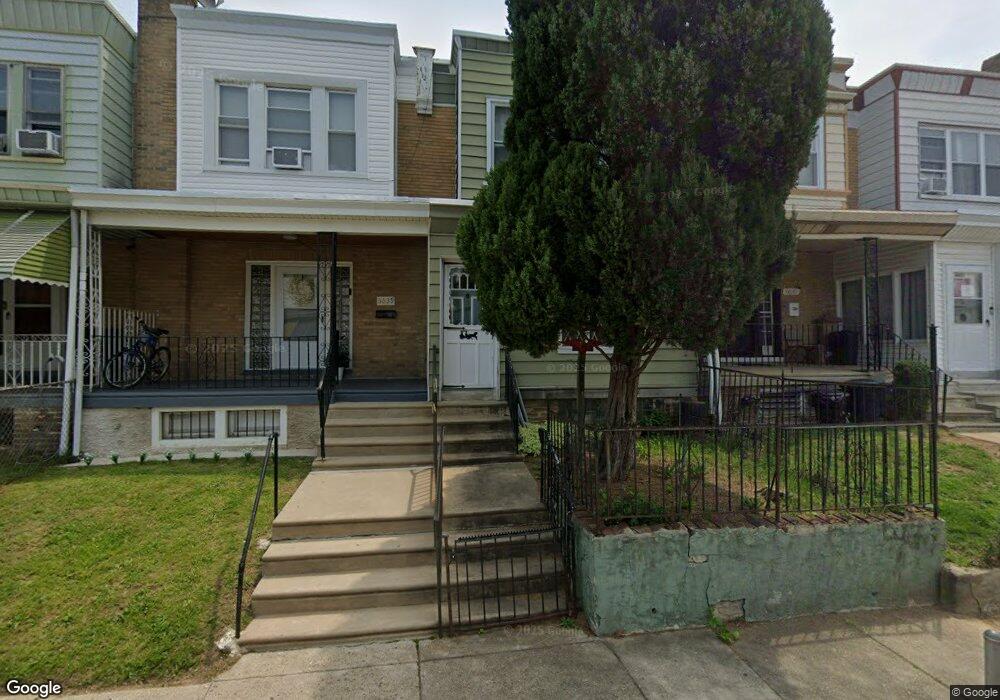
6637 N Uber St Philadelphia, PA 19138
West Oak Lane NeighborhoodEstimated Value: $180,972 - $225,000
3
Beds
1
Bath
1,024
Sq Ft
$189/Sq Ft
Est. Value
About This Home
This home is located at 6637 N Uber St, Philadelphia, PA 19138 and is currently estimated at $193,993, approximately $189 per square foot. 6637 N Uber St is a home located in Philadelphia County with nearby schools including William Rowen School, Gen. Louis Wagner Middle School, and Martin Luther King High School.
Ownership History
Date
Name
Owned For
Owner Type
Purchase Details
Closed on
Apr 8, 2022
Sold by
Derice Brown-Portley
Bought by
Brown Antrell L
Current Estimated Value
Purchase Details
Closed on
Apr 23, 2013
Sold by
Brown Derice A and Estate Of Marie Green Jeffries
Bought by
Brown-Portley Derice
Purchase Details
Closed on
Oct 26, 2007
Sold by
Brown Derice
Bought by
Jeffries Marie Green
Purchase Details
Closed on
Jan 11, 2006
Sold by
Jeffries Marie Green
Bought by
Brown Derice
Create a Home Valuation Report for This Property
The Home Valuation Report is an in-depth analysis detailing your home's value as well as a comparison with similar homes in the area
Home Values in the Area
Average Home Value in this Area
Purchase History
| Date | Buyer | Sale Price | Title Company |
|---|---|---|---|
| Brown Antrell L | -- | Clarke Gerald R | |
| Brown-Portley Derice | -- | None Available | |
| Jeffries Marie Green | -- | None Available | |
| Brown Derice | -- | None Available |
Source: Public Records
Tax History Compared to Growth
Tax History
| Year | Tax Paid | Tax Assessment Tax Assessment Total Assessment is a certain percentage of the fair market value that is determined by local assessors to be the total taxable value of land and additions on the property. | Land | Improvement |
|---|---|---|---|---|
| 2025 | $1,867 | $158,500 | $31,700 | $126,800 |
| 2024 | $1,867 | $158,500 | $31,700 | $126,800 |
| 2023 | $1,867 | $133,400 | $26,680 | $106,720 |
| 2022 | $1,158 | $133,400 | $26,680 | $106,720 |
| 2021 | $1,383 | $0 | $0 | $0 |
| 2020 | $1,383 | $0 | $0 | $0 |
| 2019 | $1,426 | $0 | $0 | $0 |
| 2018 | $1,278 | $0 | $0 | $0 |
| 2017 | $1,278 | $0 | $0 | $0 |
| 2016 | $1,278 | $0 | $0 | $0 |
| 2015 | $1,190 | $0 | $0 | $0 |
| 2014 | -- | $88,800 | $7,453 | $81,347 |
| 2012 | -- | $12,864 | $2,228 | $10,636 |
Source: Public Records
Map
Nearby Homes
- 6625 Ogontz Ave
- 6732 Ogontz Ave
- 6603 Ogontz Ave
- 1816 67th Ave
- 6629 N Gratz St
- 6609 N Gratz St
- 6600 N Opal St
- 2022 66th Ave
- 1733 67th Ave
- 1731 67th Ave
- 6518 Ogontz Ave
- 2056 Eastburn Ave
- 6731 N Woodstock St
- 6733 N Woodstock St
- 1716 67th Ave
- 6558 Limekiln Pike
- 6637 N Bouvier St
- 6869 Forrest Ave
- 1729 68th Ave
- 1720 68th Ave
- 6635 N Uber St
- 6639 N Uber St
- 6633 N Uber St
- 6641 N Uber St
- 6643 N Uber St
- 6631 N Uber St
- 6629 N Uber St
- 6645 N Uber St
- 6647 N Uber St
- 6627 N Uber St
- 6626 Ogontz Ave
- 6628 Ogontz Ave
- 6624 Ogontz Ave
- 6630 Ogontz Ave
- 6649 N Uber St
- 6625 N Uber St
- 6622 Ogontz Ave
- 6620 Ogontz Ave
- 6632 Ogontz Ave
- 6638 N Uber St