Estimated Value: $164,000 - $242,273
3
Beds
3
Baths
2,042
Sq Ft
$95/Sq Ft
Est. Value
About This Home
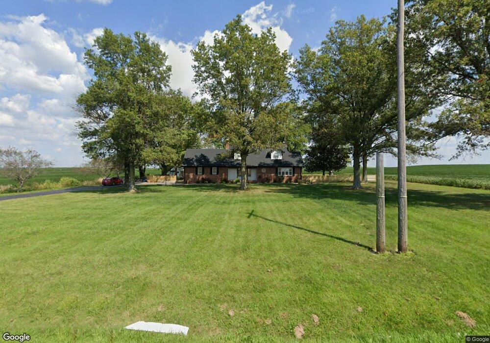
This home is located at 6638 State Route 270 W, Clay, KY 42404 and is currently estimated at $193,068, approximately $94 per square foot. 6638 State Route 270 W is a home located in Webster County with nearby schools including Webster County High School.
Ownership History
Date
Name
Owned For
Owner Type
Purchase Details
Closed on
Jan 23, 2017
Sold by
Miller Jerry A and Miller Kathy G
Bought by
Reeves Jesse Daniel and Reeves Nichole Lynn
Current Estimated Value
Home Financials for this Owner
Home Financials are based on the most recent Mortgage that was taken out on this home.
Original Mortgage
$141,391
Outstanding Balance
$117,439
Interest Rate
4.4%
Mortgage Type
FHA
Estimated Equity
$75,629
Create a Home Valuation Report for This Property
The Home Valuation Report is an in-depth analysis detailing your home's value as well as a comparison with similar homes in the area
Home Values in the Area
Average Home Value in this Area
Purchase History
| Date | Buyer | Sale Price | Title Company |
|---|---|---|---|
| Reeves Jesse Daniel | $144,000 | Foreman Watson Land Title |
Source: Public Records
Mortgage History
| Date | Status | Borrower | Loan Amount |
|---|---|---|---|
| Open | Reeves Jesse Daniel | $141,391 |
Source: Public Records
Tax History Compared to Growth
Tax History
| Year | Tax Paid | Tax Assessment Tax Assessment Total Assessment is a certain percentage of the fair market value that is determined by local assessors to be the total taxable value of land and additions on the property. | Land | Improvement |
|---|---|---|---|---|
| 2024 | $1,938 | $172,600 | $0 | $0 |
| 2023 | $1,747 | $154,700 | $0 | $0 |
| 2022 | $1,753 | $154,700 | $0 | $0 |
| 2021 | $1,720 | $149,500 | $0 | $0 |
| 2020 | $1,747 | $149,500 | $0 | $0 |
| 2019 | $1,642 | $144,000 | $0 | $0 |
| 2018 | $1,639 | $144,000 | $0 | $0 |
| 2017 | $1,156 | $104,400 | $0 | $0 |
| 2016 | $1,107 | $104,400 | $0 | $0 |
| 2015 | -- | $97,100 | $0 | $0 |
| 2012 | -- | $97,100 | $0 | $0 |
Source: Public Records
Map
Nearby Homes
- 8618 State Route 132 W
- 19 Russell St
- 68 Nelson St
- 86 Taylor St
- 154 Taylor St
- 329 W Railroad St
- 4793 S St Rt 109
- 3535 State Route 2837
- 105 Ewing Place
- 173 Green Rd
- 1501 Old Henderson Rd
- 000 Kentucky 120
- 0 Kentucky 120
- 201 Marlin St
- 314 N Willow St
- 200 N Finley Ave
- 106 N Broadway St
- 130 E Main St
- 0 Bellville Rd
- 700 Church St
- 6761 State Route 270 W
- 6732 State Route 270 W
- 6445 State Route 270 W
- 6410 State Route 270 W
- 6993 State Route 270 W
- 410 Jess White Rd
- 5987 State Route 270 W
- 357 Lisman St
- 343 Lisman St
- 283 Lisman St
- 288 Lisman St
- 239 Blackburn St
- 421 Ln Railroad Bed Rd
- 255 Lisman St
- 254 Lisman St
- 254 Lisman St
- 112 Blackburn St
- 42 Blackburn St
- 242 Lisman St
- 391 Ln Railroad Bed Rd