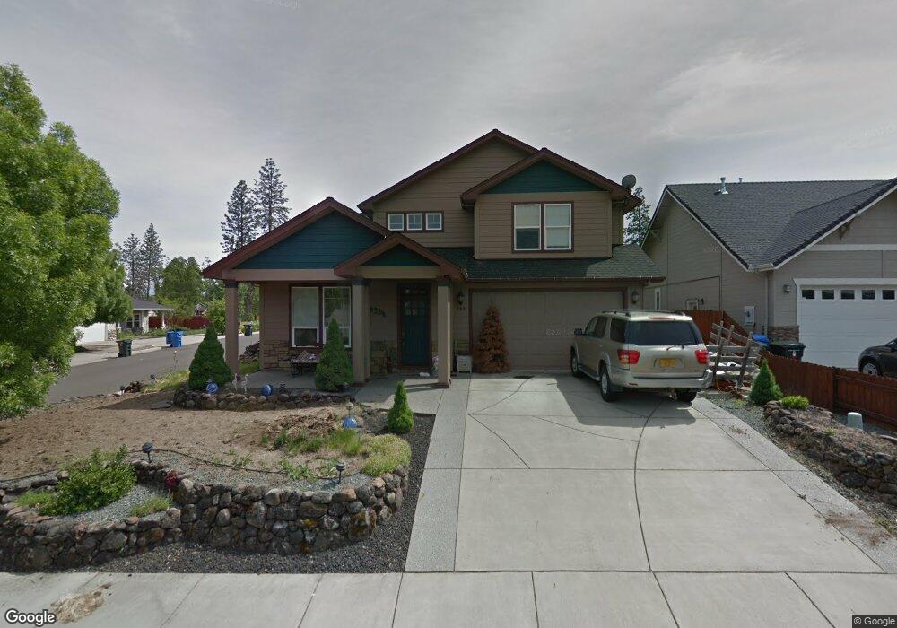
664 Cedarwood Dr Eagle Point, OR 97524
Estimated Value: $528,890 - $592,000
4
Beds
3
Baths
2,660
Sq Ft
$215/Sq Ft
Est. Value
About This Home
This home is located at 664 Cedarwood Dr, Eagle Point, OR 97524 and is currently estimated at $571,223, approximately $214 per square foot. 664 Cedarwood Dr is a home located in Jackson County with nearby schools including White Mountain Middle School, Eagle Point Middle School, and Eagle Point High School.
Ownership History
Date
Name
Owned For
Owner Type
Purchase Details
Closed on
Mar 18, 2004
Sold by
Cliff Frank Joseph and Cliff Barbara A
Bought by
Cliff Frank J and Cliff Barbara A
Current Estimated Value
Home Financials for this Owner
Home Financials are based on the most recent Mortgage that was taken out on this home.
Original Mortgage
$237,500
Outstanding Balance
$108,205
Interest Rate
5.64%
Mortgage Type
VA
Estimated Equity
$463,018
Purchase Details
Closed on
Aug 23, 2002
Sold by
Northstar Development Corp
Bought by
Cliff Frank Joseph and Cliff Barbara A
Home Financials for this Owner
Home Financials are based on the most recent Mortgage that was taken out on this home.
Original Mortgage
$240,000
Interest Rate
6.43%
Mortgage Type
VA
Create a Home Valuation Report for This Property
The Home Valuation Report is an in-depth analysis detailing your home's value as well as a comparison with similar homes in the area
Home Values in the Area
Average Home Value in this Area
Purchase History
| Date | Buyer | Sale Price | Title Company |
|---|---|---|---|
| Cliff Frank J | -- | -- | |
| Cliff Frank Joseph | $255,000 | Amerititle |
Source: Public Records
Mortgage History
| Date | Status | Borrower | Loan Amount |
|---|---|---|---|
| Open | Cliff Frank J | $237,500 | |
| Closed | Cliff Frank Joseph | $240,000 |
Source: Public Records
Tax History
| Year | Tax Paid | Tax Assessment Tax Assessment Total Assessment is a certain percentage of the fair market value that is determined by local assessors to be the total taxable value of land and additions on the property. | Land | Improvement |
|---|---|---|---|---|
| 2026 | $4,207 | $306,600 | $116,000 | $190,600 |
| 2025 | $4,107 | $331,730 | $80,330 | $251,400 |
| 2024 | $4,107 | $322,070 | $77,990 | $244,080 |
| 2023 | $3,968 | $312,690 | $75,720 | $236,970 |
| 2022 | $3,860 | $312,690 | $75,720 | $236,970 |
| 2021 | $3,746 | $303,590 | $73,520 | $230,070 |
| 2020 | $3,979 | $294,750 | $71,380 | $223,370 |
| 2019 | $3,918 | $277,840 | $67,290 | $210,550 |
| 2018 | $3,844 | $269,750 | $65,330 | $204,420 |
| 2017 | $3,749 | $269,750 | $65,330 | $204,420 |
| 2016 | $3,676 | $254,280 | $61,580 | $192,700 |
| 2015 | $3,556 | $254,280 | $61,580 | $192,700 |
| 2014 | $3,454 | $239,690 | $58,040 | $181,650 |
Source: Public Records
Map
Nearby Homes
- 616 Cedarwood Dr
- 16 Portabello Way
- 13 Portabello Way
- 179 Skyhawk Dr
- 181 Morning Dove Trail
- 0 Echo Way Unit Tax Lot 902
- 0 Echo Way Unit 220215112
- 0 Echo Way Unit Tax Lot 901
- 0 Echo Way Unit Tax Lot 900
- 91 Morning Dove Trail
- 1065 S Shasta Ave
- 210 Bogey Ln
- 51 Broken Stone Way
- 1314 S Shasta Ave Unit A
- 201 Bogey Ln
- 1288 S Shasta Ave
- 198 Prairie Landing Dr
- 187 Prairie Landing Dr
- 184 Keystone Way
- 839 St Andrews Way
- 658 Cedarwood Dr
- 16 Birch Wood
- 15 Birch Wood
- 661 Oak Wood
- 652 Cedarwood Dr
- 143 Birch Wood
- 149 Birch Wood
- 655 Oak Wood
- 665 Cedarwood Dr
- 659 Cedarwood Dr
- 671 Cedarwood Dr
- 646 Cedarwood Dr
- 653 Cedarwood Dr
- 155 Birch Wood
- 9 Fir Cir
- 649 Oak Wood
- 677 Cedarwood Dr
- 647 Cedarwood Dr
- 640 Cedarwood Dr
- 15 Fir Cir
Your Personal Tour Guide
Ask me questions while you tour the home.