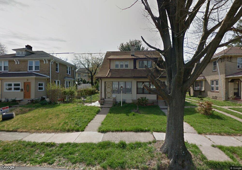
664 Rose St Lansdowne, PA 19050
Estimated Value: $180,000 - $228,000
2
Beds
1
Bath
1,296
Sq Ft
$155/Sq Ft
Est. Value
About This Home
This home is located at 664 Rose St, Lansdowne, PA 19050 and is currently estimated at $200,958, approximately $155 per square foot. 664 Rose St is a home located in Delaware County with nearby schools including Evans Elementary School, Penn Wood Middle School, and Penn Wood High School - Cypress Street Campus.
Ownership History
Date
Name
Owned For
Owner Type
Purchase Details
Closed on
Mar 10, 2005
Sold by
Pressley Clara L
Bought by
Nguyen Phi Thanh and Tran Anh Phuong
Current Estimated Value
Home Financials for this Owner
Home Financials are based on the most recent Mortgage that was taken out on this home.
Original Mortgage
$76,950
Interest Rate
5.14%
Mortgage Type
Fannie Mae Freddie Mac
Create a Home Valuation Report for This Property
The Home Valuation Report is an in-depth analysis detailing your home's value as well as a comparison with similar homes in the area
Home Values in the Area
Average Home Value in this Area
Purchase History
| Date | Buyer | Sale Price | Title Company |
|---|---|---|---|
| Nguyen Phi Thanh | $81,000 | Lawyers Title |
Source: Public Records
Mortgage History
| Date | Status | Borrower | Loan Amount |
|---|---|---|---|
| Closed | Nguyen Phi Thanh | $76,950 |
Source: Public Records
Tax History Compared to Growth
Tax History
| Year | Tax Paid | Tax Assessment Tax Assessment Total Assessment is a certain percentage of the fair market value that is determined by local assessors to be the total taxable value of land and additions on the property. | Land | Improvement |
|---|---|---|---|---|
| 2025 | $4,355 | $101,980 | $33,640 | $68,340 |
| 2024 | $4,355 | $101,980 | $33,640 | $68,340 |
| 2023 | $3,955 | $101,980 | $33,640 | $68,340 |
| 2022 | $3,771 | $101,980 | $33,640 | $68,340 |
| 2021 | $5,703 | $101,980 | $33,640 | $68,340 |
| 2020 | $3,581 | $57,340 | $19,410 | $37,930 |
| 2019 | $3,518 | $57,340 | $19,410 | $37,930 |
| 2018 | $3,469 | $57,340 | $0 | $0 |
| 2017 | $3,396 | $57,340 | $0 | $0 |
| 2016 | $315 | $57,340 | $0 | $0 |
| 2015 | $321 | $57,340 | $0 | $0 |
| 2014 | $315 | $57,340 | $0 | $0 |
Source: Public Records
Map
Nearby Homes
- 536 Cypress St
- 740 Church Ln
- 813 Arbor Rd
- 912 Myra Ave
- 702 Cedar Ave
- 711 Yeadon Ave
- 825 Laurel Rd
- 800 Bullock Ave
- 503 Bonsall Ave
- 442 Church Ln
- 438 Church Ln
- 436 Church Ln
- 435 Bonsall Ave
- 530 Orchard Ave
- 407 Church Ln
- 808 Serrill Ave
- 908 Yeadon Ave
- 6030 Cedarhurst St
- 921 Serrill Ave
- 6013 Baltimore Ave