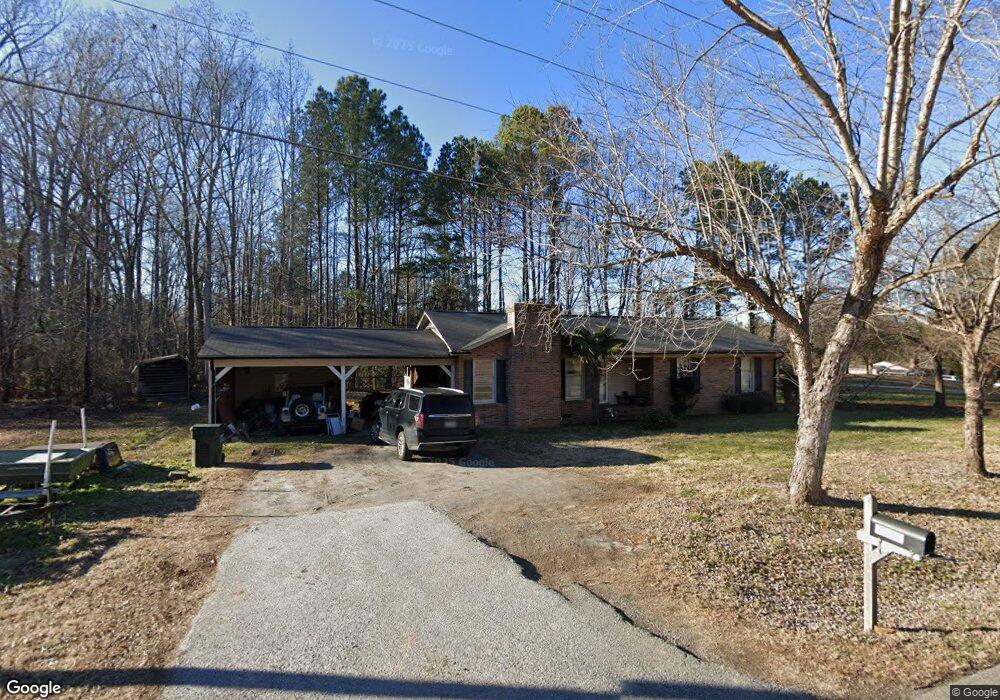
6640 Highway 557 Clover, SC 29710
Estimated Value: $31,000 - $342,000
--
Bed
--
Bath
1,472
Sq Ft
$170/Sq Ft
Est. Value
About This Home
This home is located at 6640 Highway 557, Clover, SC 29710 and is currently estimated at $250,432, approximately $170 per square foot. 6640 Highway 557 is a home with nearby schools including Griggs Road Elementary School, Clover Middle School, and Clover High School.
Ownership History
Date
Name
Owned For
Owner Type
Purchase Details
Closed on
May 15, 2025
Sold by
Merrill Michael J
Bought by
York County
Current Estimated Value
Purchase Details
Closed on
Nov 12, 2007
Sold by
Merrill Mary E
Bought by
Merrill Michael J
Purchase Details
Closed on
Apr 20, 2007
Sold by
Merrill Mary E
Bought by
Merrill Michael J
Create a Home Valuation Report for This Property
The Home Valuation Report is an in-depth analysis detailing your home's value as well as a comparison with similar homes in the area
Home Values in the Area
Average Home Value in this Area
Purchase History
| Date | Buyer | Sale Price | Title Company |
|---|---|---|---|
| York County | $31,100 | None Listed On Document | |
| Merrill Michael J | -- | None Available | |
| Merrill Michael J | -- | None Available |
Source: Public Records
Tax History Compared to Growth
Tax History
| Year | Tax Paid | Tax Assessment Tax Assessment Total Assessment is a certain percentage of the fair market value that is determined by local assessors to be the total taxable value of land and additions on the property. | Land | Improvement |
|---|---|---|---|---|
| 2025 | $768 | $5,607 | $1,203 | $4,404 |
| 2024 | $689 | $4,876 | $1,139 | $3,737 |
| 2023 | $707 | $4,876 | $1,139 | $3,737 |
| 2022 | $582 | $4,876 | $1,139 | $3,737 |
| 2021 | -- | $4,876 | $1,139 | $3,737 |
| 2020 | $552 | $4,876 | $0 | $0 |
| 2019 | $524 | $4,240 | $0 | $0 |
| 2018 | $526 | $4,240 | $0 | $0 |
| 2017 | $490 | $4,240 | $0 | $0 |
| 2016 | $462 | $4,240 | $0 | $0 |
| 2014 | $559 | $4,240 | $1,280 | $2,960 |
| 2013 | $559 | $4,900 | $1,280 | $3,620 |
Source: Public Records
Map
Nearby Homes
- 2599 Highway 557 None
- 221 Burree Rd
- 10.64 AC Burree Rd Unit 6
- 10.64 AC Burree Rd
- 9 AC Burree Rd
- 3048 Patrick Place Cir Unit 10
- 3040 Patrick Place Cir
- 109 Highland Forest Dr
- 1300 Dunmore Ct
- 961 Poplar Forest Ridge
- 1965 Leesburg Dr
- 1961 Leesburg Dr
- 1909 Leesburg Dr
- Lot 24 Mute Swan Haven Ln
- Lot 17 Great Blue Path
- Lot 36 Snow Goose Walk Ct
- Lot 37 Snow Goose Walk Ct
- Lot 35 Snow Goose Walk Ct
- Lot 15 American Bittern Path
- 1168 Birchwood Dr
- 6680 Highway 557
- 6670 Highway 557
- 6657 Highway 557
- 6728 Highway 557
- 6660 Highway 557
- 6525 Highway 557
- LOT Highway 557 Unit LOT
- 2530 Eleanor Ct
- 2529 Eleanor Ct
- 6769 Highway 557
- 6632 Highway 557
- 2525 Mary Hope Ln
- 2522 Eleanor Ct
- 2521 Eleanor Ct
- 2516 Eleanor Ct
- 2530 Edgecomb Dr
- 6788 Highway 557
- 2533 Mary Hope Ln
- 2535 Edgecomb Dr
- 1 Mary Hope Ln