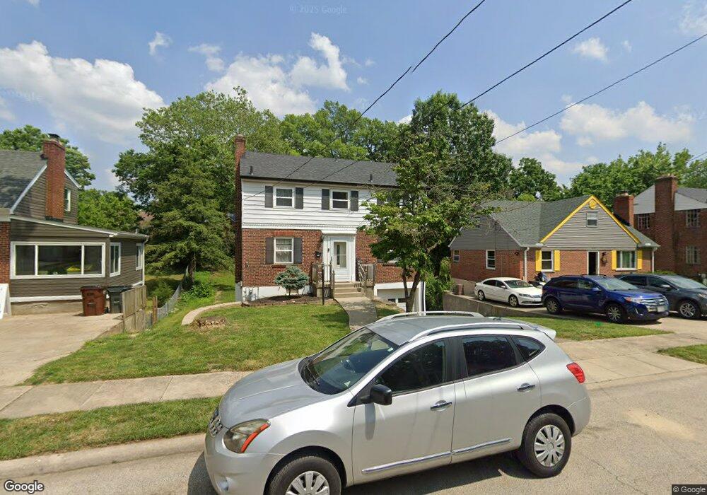
6642 Sampson Ln Cincinnati, OH 45236
Estimated Value: $234,543 - $295,000
3
Beds
2
Baths
1,324
Sq Ft
$205/Sq Ft
Est. Value
About This Home
This home is located at 6642 Sampson Ln, Cincinnati, OH 45236 and is currently estimated at $271,886, approximately $205 per square foot. 6642 Sampson Ln is a home located in Hamilton County with nearby schools including Silverton Paideia Elementary School, Shroder High School, and Clark Montessori High School.
Ownership History
Date
Name
Owned For
Owner Type
Purchase Details
Closed on
Aug 20, 1992
Sold by
Crawford George F 2Nd
Bought by
Fowler Mark C
Current Estimated Value
Create a Home Valuation Report for This Property
The Home Valuation Report is an in-depth analysis detailing your home's value as well as a comparison with similar homes in the area
Home Values in the Area
Average Home Value in this Area
Purchase History
| Date | Buyer | Sale Price | Title Company |
|---|---|---|---|
| Fowler Mark C | $72,900 | -- |
Source: Public Records
Tax History
| Year | Tax Paid | Tax Assessment Tax Assessment Total Assessment is a certain percentage of the fair market value that is determined by local assessors to be the total taxable value of land and additions on the property. | Land | Improvement |
|---|---|---|---|---|
| 2025 | $3,234 | $50,481 | $13,615 | $36,866 |
| 2023 | $3,059 | $50,481 | $13,615 | $36,866 |
| 2022 | $2,384 | $33,383 | $10,241 | $23,142 |
| 2021 | $2,241 | $33,383 | $10,241 | $23,142 |
| 2020 | $2,277 | $33,383 | $10,241 | $23,142 |
| 2019 | $2,479 | $32,729 | $10,042 | $22,687 |
| 2018 | $2,483 | $32,729 | $10,042 | $22,687 |
| 2017 | $2,372 | $32,729 | $10,042 | $22,687 |
| 2016 | $2,455 | $33,268 | $8,964 | $24,304 |
| 2015 | $2,220 | $33,268 | $8,964 | $24,304 |
| 2014 | $2,234 | $33,268 | $8,964 | $24,304 |
| 2013 | $2,524 | $36,964 | $9,958 | $27,006 |
Source: Public Records
Map
Nearby Homes
- 6705 Elwynne Dr
- 6656 Plainfield Rd
- 6829 Alpine Ave
- 5635 Euclid Rd
- 3964 Zinsle Ave
- 4155 Home St
- 3906 Standish Ave
- 3911 E Gatewood Ln
- 4248 South Ave
- 3824 Standish Ave
- 3962 S Fordham Place
- 7034 East Ave
- 4025 Deer Park Ave
- 3765 Iona Ave
- 3946 Cedarwood Place
- 6508 Coleridge Ave
- 6097 W Fordham Place
- 6501 Coleridge Ave
- 3921 Cedarwood Place
- 6460 Mchugh Place
- 6640 Sampson Ln
- 6638 Sampson Ln
- 6650 Sampson Ln
- 6637 Elwynne Dr
- 6633 Elwynne Dr
- 6641 Elwynne Dr
- 6636 Sampson Ln
- 6629 Elwynne Dr
- 6645 Elwynne Dr
- 6625 Elwynne Dr
- 6647 Sampson Ln
- 6634 Sampson Ln
- 6700 Sampson Ln
- 6637 Sampson Ln
- 6651 Sampson Ln
- 6621 Elwynne Dr
- 6633 Sampson Ln
- 6701 Elwynne Dr
- 6704 Sampson Ln
- 50 Elwynne Dr
Your Personal Tour Guide
Ask me questions while you tour the home.