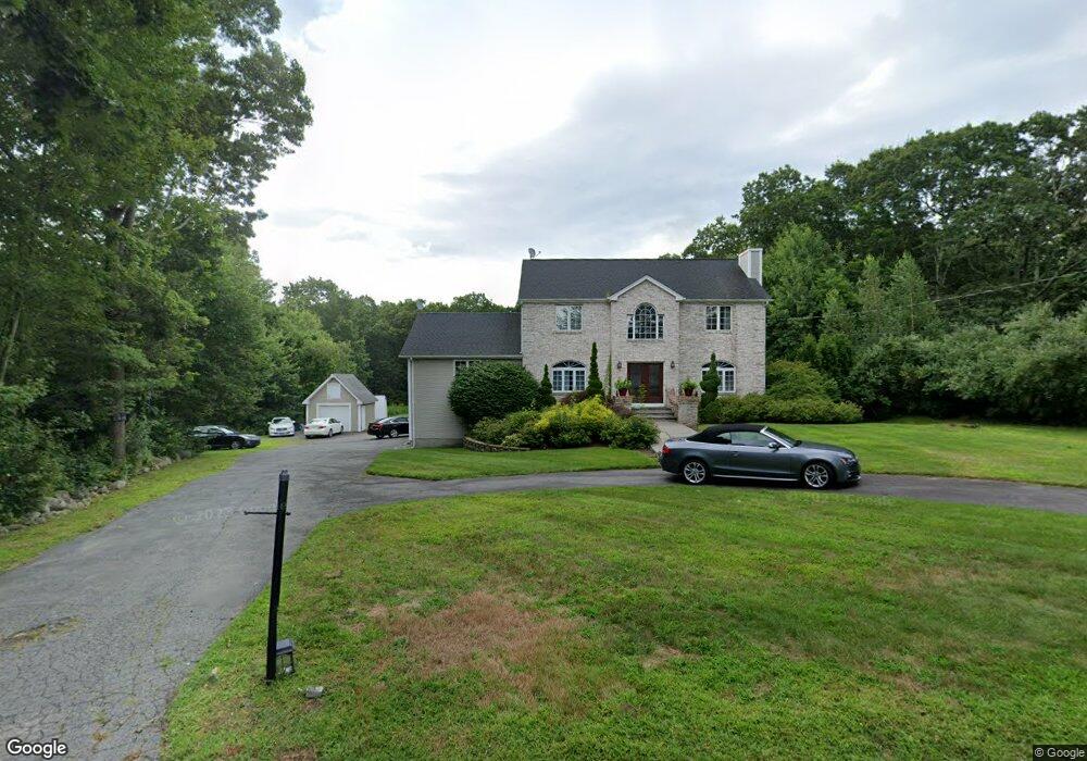
665 Bound Rd Woonsocket, RI 02895
North Cumberland NeighborhoodEstimated Value: $556,000 - $657,389
3
Beds
3
Baths
2,660
Sq Ft
$227/Sq Ft
Est. Value
About This Home
This home is located at 665 Bound Rd, Woonsocket, RI 02895 and is currently estimated at $603,347, approximately $226 per square foot. 665 Bound Rd is a home with nearby schools including Community School, North Cumberland Middle School, and Cumberland High School.
Ownership History
Date
Name
Owned For
Owner Type
Purchase Details
Closed on
Apr 4, 2011
Sold by
Bruno Christopher and Bruno Luis Ana
Bought by
Bruno Christopher J and Bruno Ana Luis
Current Estimated Value
Home Financials for this Owner
Home Financials are based on the most recent Mortgage that was taken out on this home.
Original Mortgage
$252,000
Interest Rate
5.04%
Purchase Details
Closed on
Jun 2, 2000
Sold by
Pereira Joseph L
Bought by
Bruno Christopher J and Bruno Luis Ana
Create a Home Valuation Report for This Property
The Home Valuation Report is an in-depth analysis detailing your home's value as well as a comparison with similar homes in the area
Home Values in the Area
Average Home Value in this Area
Purchase History
| Date | Buyer | Sale Price | Title Company |
|---|---|---|---|
| Bruno Christopher J | -- | -- | |
| Bruno Christopher J | $225,000 | -- |
Source: Public Records
Mortgage History
| Date | Status | Borrower | Loan Amount |
|---|---|---|---|
| Open | Bruno Christopher J | $315,000 | |
| Closed | Bruno Christopher J | $252,000 | |
| Previous Owner | Bruno Christopher J | $30,000 |
Source: Public Records
Tax History
| Year | Tax Paid | Tax Assessment Tax Assessment Total Assessment is a certain percentage of the fair market value that is determined by local assessors to be the total taxable value of land and additions on the property. | Land | Improvement |
|---|---|---|---|---|
| 2025 | $7,496 | $610,900 | $178,400 | $432,500 |
| 2024 | $7,304 | $611,200 | $178,400 | $432,800 |
| 2023 | $7,102 | $611,200 | $178,400 | $432,800 |
| 2022 | $6,997 | $466,800 | $138,700 | $328,100 |
| 2021 | $6,881 | $466,800 | $138,700 | $328,100 |
| 2020 | $6,685 | $466,800 | $138,700 | $328,100 |
| 2019 | $6,732 | $423,900 | $126,100 | $297,800 |
| 2018 | $6,537 | $423,900 | $126,100 | $297,800 |
| 2017 | $6,448 | $423,900 | $126,100 | $297,800 |
| 2016 | $6,887 | $403,200 | $128,200 | $275,000 |
| 2015 | $6,887 | $403,200 | $128,200 | $275,000 |
| 2014 | $6,887 | $403,200 | $128,200 | $275,000 |
| 2013 | $6,705 | $424,900 | $130,200 | $294,700 |
Source: Public Records
Map
Nearby Homes
- 20 Nature View Dr
- 25 Nature View Dr
- 9 Pebble Cir Unit 9
- 24 Palmetto Dr Unit 24
- 21 Palmetto Dr Unit 21
- 65 Palmetto Dr Unit 65
- 365 W Wrentham Rd
- 9 Brookfield Ln
- 4 Carnation St
- 180 Pine Swamp Rd
- 56 Pine Swamp Rd
- 172 Pine Swamp Rd
- 727 Mendon Rd
- 202 Paine St
- 95 Mitris Blvd
- 1250 Pulaski Blvd
- 194 Paine St
- 82 Paine St
- 101 Pine Grove Ave
- 21 Irving St
Your Personal Tour Guide
Ask me questions while you tour the home.