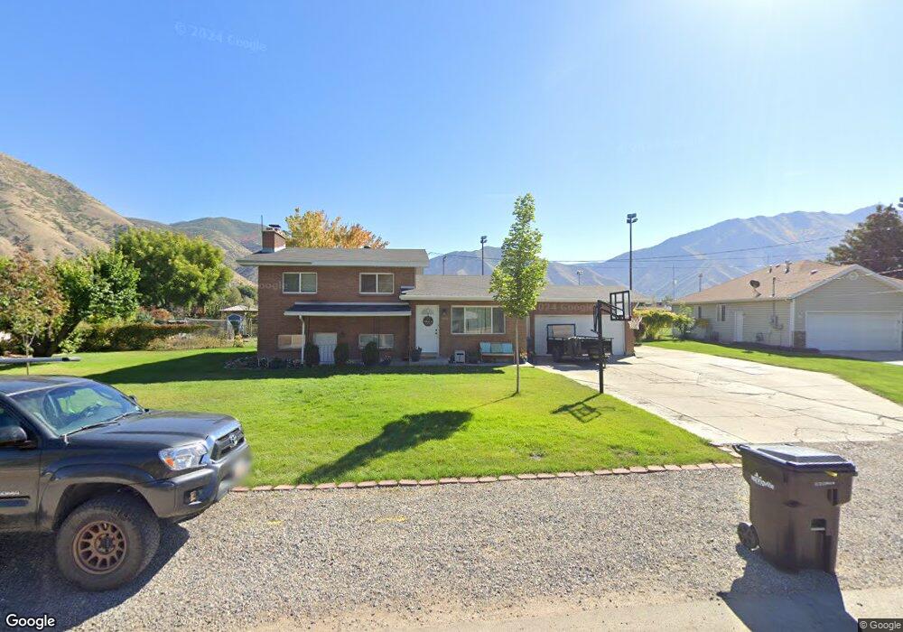
665 S Weight Ave Springville, UT 84663
East Hobble Creek NeighborhoodEstimated Value: $443,000 - $492,985
5
Beds
2
Baths
1,098
Sq Ft
$431/Sq Ft
Est. Value
About This Home
This home is located at 665 S Weight Ave, Springville, UT 84663 and is currently estimated at $472,996, approximately $430 per square foot. 665 S Weight Ave is a home located in Utah County with nearby schools including Brookside School, Springville Junior High School, and Springville High School.
Ownership History
Date
Name
Owned For
Owner Type
Purchase Details
Closed on
May 22, 2018
Sold by
Weight Jeffrey R and Weight Susan M
Bought by
Hylton Stephen John and Hylton Elizabeth Anne
Current Estimated Value
Home Financials for this Owner
Home Financials are based on the most recent Mortgage that was taken out on this home.
Original Mortgage
$268,850
Outstanding Balance
$231,489
Interest Rate
4.4%
Mortgage Type
New Conventional
Estimated Equity
$241,507
Purchase Details
Closed on
Jul 27, 2000
Sold by
Weight Coe Jane and Weight Jeffrey Ralph
Bought by
Weight Jeffrey R and Weight Susan M
Home Financials for this Owner
Home Financials are based on the most recent Mortgage that was taken out on this home.
Original Mortgage
$162,101
Interest Rate
8.2%
Create a Home Valuation Report for This Property
The Home Valuation Report is an in-depth analysis detailing your home's value as well as a comparison with similar homes in the area
Home Values in the Area
Average Home Value in this Area
Purchase History
| Date | Buyer | Sale Price | Title Company |
|---|---|---|---|
| Hylton Stephen John | -- | None Available | |
| Weight Jeffrey R | -- | Titlewriters Inc |
Source: Public Records
Mortgage History
| Date | Status | Borrower | Loan Amount |
|---|---|---|---|
| Open | Hylton Stephen John | $268,850 | |
| Previous Owner | Weight Jeffrey R | $162,101 |
Source: Public Records
Tax History Compared to Growth
Tax History
| Year | Tax Paid | Tax Assessment Tax Assessment Total Assessment is a certain percentage of the fair market value that is determined by local assessors to be the total taxable value of land and additions on the property. | Land | Improvement |
|---|---|---|---|---|
| 2025 | $2,195 | $445,100 | $183,300 | $261,800 |
| 2024 | $2,195 | $224,840 | $0 | $0 |
| 2023 | $2,136 | $219,065 | $0 | $0 |
| 2022 | $2,326 | $234,245 | $0 | $0 |
| 2021 | $2,057 | $322,500 | $132,000 | $190,500 |
| 2020 | $1,836 | $279,100 | $97,800 | $181,300 |
| 2019 | $1,625 | $251,500 | $81,500 | $170,000 |
| 2018 | $1,642 | $242,400 | $75,800 | $166,600 |
| 2017 | $1,507 | $118,195 | $0 | $0 |
| 2016 | $1,404 | $107,910 | $0 | $0 |
| 2015 | $1,373 | $107,910 | $0 | $0 |
| 2014 | $1,382 | $107,910 | $0 | $0 |
Source: Public Records
Map
Nearby Homes
- 509 Brookside Dr
- 802 S Brookside Dr
- 1062 E 350 S
- 879 E 900 S
- 649 Swenson Ave Unit 4
- 2554 E 350 S Unit 4
- 639 Swenson Ave Unit 4
- 1185 Hillcrest Dr
- 633 E 800 St S
- 645 S Red Devil Dr
- 630 E 800 St S
- 615 E 800 St S
- 581 E 800 St S
- 177 S Canyon Ave
- 445 Swenson Ave
- 170 S 1300 E
- 629 E 800 St S
- 626 E 800 St S
- 579 E 800 St S
- 607 E 800 St S
- 685 S Weight Ave
- 635 S Weight Ave
- 586 Brookside Dr
- 572 Brookside Dr
- 610 Brookside Dr
- 598 S Brookside Dr
- 558 Brookside Dr
- 624 Brookside Dr
- 605 S Weight Ave
- 638 Brookside Dr
- 530 Brookside Dr
- 652 Brookside Dr
- 585 S Weight Ave
- 591 Brookside Dr
- 518 Brookside Dr
- 611 Brookside Dr
- 561 Brookside Dr
- 666 Brookside Dr
- 629 Brookside Dr
- 541 Brookside Dr