
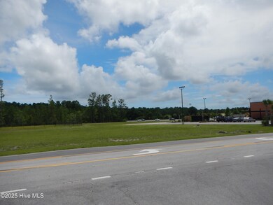
6650 Highway 70 W Newport, NC 28570
Estimated payment $4,611/month
Highlights
- 1.08 Acre Lot
- Restaurant
- Community Barbecue Grill
- Morehead City Primary School Rated A-
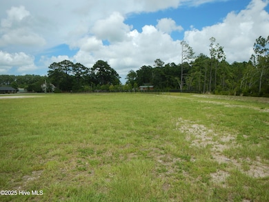
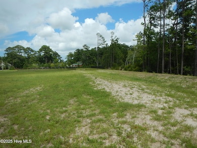
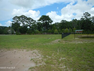
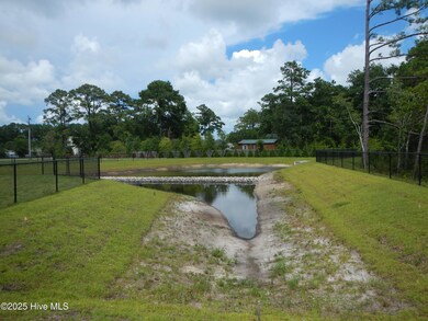
About This Lot
SUBJECT PROPERTY HAS BEEN CLEARED AND MAINTAINED AVAILABLE UTILITIES TRU NEWPORT MUNICIPAL WATER&SEWER, DUKE ENERGY PROVIDES ELECTRIC,PIEDMONT NATURAL GAS.
Property Details
Property Type
- Land
Est. Annual Taxes
- $7,129
Lot Details
- 1.08 Acre Lot
- Chain Link Fence
- Cleared Lot
- Property is zoned COMMERCIAL HW
HOA Fees
- $83 Monthly HOA Fees
Home Design
- Mixed Use
Schools
- Newport Elementary School
- Broad Creek Middle School
- Croatan High School
Utilities
- Heating System Uses Gas
- Gas Tank Leased
- Propane
- Co-Op Water
- Fuel Tank
- Cable TV Available
Listing and Financial Details
- Tax Lot LOT 3
- Assessor Parcel Number 633820905523000
Community Details
Overview
- Newport Crossroads Association
- Roberts Road Property Owners Association,Inc. Association
- Newport First, Llc Subdivision
- The community has rules related to deed restrictions
Amenities
- Community Barbecue Grill
- Restaurant
Map
Home Values in the Area
Average Home Value in this Area
Tax History
| Year | Tax Paid | Tax Assessment Tax Assessment Total Assessment is a certain percentage of the fair market value that is determined by local assessors to be the total taxable value of land and additions on the property. | Land | Improvement |
|---|---|---|---|---|
| 2025 | $4,881 | $2,125,895 | $517,920 | $1,607,975 |
| 2024 | $3,484 | $995,923 | $264,620 | $731,303 |
| 2023 | $915 | $264,620 | $264,620 | $0 |
| 2022 | $1,672 | $501,974 | $501,974 | $0 |
| 2021 | $2,209 | $501,974 | $501,974 | $0 |
| 2020 | $1,657 | $501,974 | $501,974 | $0 |
| 2019 | $1,556 | $501,974 | $501,974 | $0 |
| 2017 | $1,556 | $501,974 | $501,974 | $0 |
| 2016 | $1,556 | $501,974 | $501,974 | $0 |
| 2015 | $1,506 | $501,974 | $501,974 | $0 |
| 2014 | $1,047 | $348,974 | $348,974 | $0 |
Property History
| Date | Event | Price | List to Sale | Price per Sq Ft | Prior Sale |
|---|---|---|---|---|---|
| 07/09/2025 07/09/25 | For Sale | $750,000 | +114.3% | -- | |
| 07/09/2025 07/09/25 | For Sale | $350,000 | -46.2% | -- | |
| 10/06/2021 10/06/21 | Sold | $650,000 | -7.0% | $4 / Sq Ft | View Prior Sale |
| 02/24/2021 02/24/21 | Pending | -- | -- | -- | |
| 01/12/2021 01/12/21 | For Sale | $699,000 | +7.5% | $4 / Sq Ft | |
| 12/31/2020 12/31/20 | Off Market | $650,000 | -- | -- | |
| 02/03/2020 02/03/20 | For Sale | $699,000 | -- | $4 / Sq Ft |
Purchase History
| Date | Type | Sale Price | Title Company |
|---|---|---|---|
| Deed | $650,000 | None Available | |
| Deed | -- | None Available |
Mortgage History
| Date | Status | Loan Amount | Loan Type |
|---|---|---|---|
| Open | $650,000 | Commercial |
Source: Hive MLS
MLS Number: 100519505
APN: 6338.20.90.3520000
Disclaimer: Certain information contained herein is derived from information provided by parties other than Homes.com. All information provided is deemed reliable, but is not guaranteed to be accurate and should be independently verified.
![]() The data relating to real estate on this web site comes in part from the Internet Data Exchange program of Hive MLS LLC. All information is deemed reliable but not guaranteed and should be independently verified. All properties are subject to prior sale, change, or withdrawal. Neither listing broker(s) nor Homesnap, Inc. shall be responsible for any typographical errors, misinformation, or misprints, and shall be held totally harmless from any damages arising from reliance upon these data. ©2025 Hive MLS LLC
The data relating to real estate on this web site comes in part from the Internet Data Exchange program of Hive MLS LLC. All information is deemed reliable but not guaranteed and should be independently verified. All properties are subject to prior sale, change, or withdrawal. Neither listing broker(s) nor Homesnap, Inc. shall be responsible for any typographical errors, misinformation, or misprints, and shall be held totally harmless from any damages arising from reliance upon these data. ©2025 Hive MLS LLC
- 5320 Highway 70 W
- 806 Lord Granville Dr
- 178 Arthur Farm Rd
- 137 Zacchaeus Ave
- 212 Lord Granville Dr
- 400 Hillcrest Dr
- 124 Zacchaeus Ave
- 404 Hillcrest Dr
- 476 Highway 24 - B
- 108 Brandywine Blvd
- 113 Fairway Dr W
- 476 Highway 24 - A
- 102 Iris Ct
- 341 Mccabe Rd
- 509 Village Green Dr Unit A
- 215 Oak Dr
- 108 Phillips Landing Dr
- 527 Village Green Dr Unit A
- 535 Village Green Dr Unit A
- 209 Coventry Rd
- 133 Wildwood Rd
- 203 Westchester Dr
- 357 Mccabe Rd
- 155 Beaufort Ct
- 103 Bogue Landing Dr
- 502 E Branch Dr
- 500 Mansfield Pkwy
- 4513 Country Club Rd Unit C104
- 4000 Galantis Dr
- 4005 Galantis Dr
- 3839 Galantis
- 3905 Guardian Ave Unit B10
- 1202 Woods Ct
- 204 Two Oaks Ct
- 3800 Guardian Ave Unit 32
- 525 Salter Path Rd Unit A-4
- 108 Pelican Dr Unit H
- 3320 Bridges St Unit 9
- 3309 Bridges St Unit A22
- 3205 Bridges St
