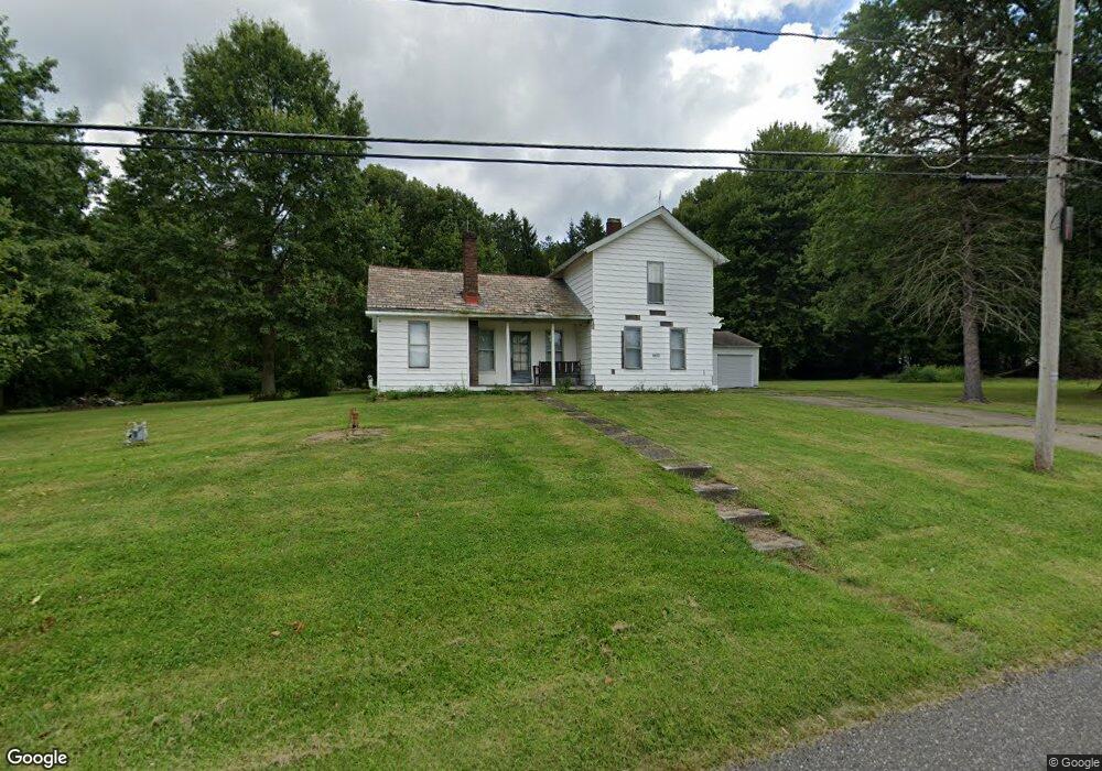
6653 Stewart Sharon Rd Brookfield, OH 44403
Estimated Value: $88,000 - $165,000
2
Beds
1
Bath
1,242
Sq Ft
$105/Sq Ft
Est. Value
About This Home
This home is located at 6653 Stewart Sharon Rd, Brookfield, OH 44403 and is currently estimated at $130,501, approximately $105 per square foot. 6653 Stewart Sharon Rd is a home located in Trumbull County with nearby schools including Brookfield Elementary School, Brookfield Middle School, and Brookfield High School.
Ownership History
Date
Name
Owned For
Owner Type
Purchase Details
Closed on
Apr 1, 2022
Sold by
Ghizzoni Dustin D
Bought by
Dustin And Daniela Ghizzoni Family Trust
Current Estimated Value
Purchase Details
Closed on
Sep 13, 2017
Sold by
Ghizzoni Jim and Ghizzoni Alan A
Bought by
Ghizzoni Dustin D
Purchase Details
Closed on
Jan 1, 1990
Bought by
Theresa Ghizzoni
Create a Home Valuation Report for This Property
The Home Valuation Report is an in-depth analysis detailing your home's value as well as a comparison with similar homes in the area
Home Values in the Area
Average Home Value in this Area
Purchase History
| Date | Buyer | Sale Price | Title Company |
|---|---|---|---|
| Dustin And Daniela Ghizzoni Family Trust | -- | -- | |
| Ghizzoni Dustin D | $28,600 | None Available | |
| Theresa Ghizzoni | -- | -- |
Source: Public Records
Tax History Compared to Growth
Tax History
| Year | Tax Paid | Tax Assessment Tax Assessment Total Assessment is a certain percentage of the fair market value that is determined by local assessors to be the total taxable value of land and additions on the property. | Land | Improvement |
|---|---|---|---|---|
| 2024 | $1,620 | $34,520 | $7,530 | $26,990 |
| 2023 | $1,620 | $23,700 | $7,530 | $16,170 |
| 2022 | $1,358 | $23,460 | $6,830 | $16,630 |
| 2021 | $1,274 | $23,460 | $6,830 | $16,630 |
| 2020 | $1,266 | $23,460 | $6,830 | $16,630 |
| 2019 | $1,226 | $21,180 | $6,340 | $14,840 |
| 2018 | $1,215 | $21,180 | $6,340 | $14,840 |
| 2017 | $1,214 | $21,180 | $6,340 | $14,840 |
| 2016 | $1,191 | $19,990 | $7,070 | $12,920 |
| 2015 | $1,193 | $19,990 | $7,070 | $12,920 |
| 2014 | $1,187 | $19,990 | $7,070 | $12,920 |
| 2013 | $1,223 | $20,970 | $7,070 | $13,900 |
Source: Public Records
Map
Nearby Homes
- 6855 Stewart Sharon Rd
- 887 State Route 7 SE
- 7182 Stewart Sharon Rd
- 6976 White Oak Dr
- 7111 Pine Grove Dr
- 7440 Stewart Sharon Rd
- 6984 Warren Sharon Rd
- 7086 Warren Sharon Rd
- 7091 Warren Sharon Rd
- 1354 Stevenson Rd
- 6130 Warren Sharon Rd
- 7085 Sunnydell Dr
- 7290 Lee Rd NE
- 1472 Warner Rd
- 1511 Cullinan Ave
- 209 Wyngate Dr
- 550 Warner Rd
- 1952 Hubbard Masury Rd
- 1975 Warner Rd
- 1212 State Route 7 NE
- 6683 Stewart Sharon Rd
- 6676 Stewart Sharon Rd
- 6664 Stewart Sharon Rd
- 6654 Stewart Sharon Rd
- 6638 Stewart Sharon Rd
- 6616 Stewart Sharon Rd
- 6619 Stewart Sharon Rd
- 6719 Stewart Sharon Rd
- 6723 Stewart Sharon Rd
- 6591 Stewart Sharon Rd
- 6729 Stewart Sharon Rd
- 6554 Stewart Sharon Rd
- 6582 Stewart Sharon Rd
- 6596 Stewart Sharon Rd
- 6559 Stewart Sharon Rd
- 1159 Collar Price Rd
- 6757 Stewart Sharon Rd
- 1171 Collar Price Rd
- 6728 Stewart Sharon Rd
- 6716 Stewart Sharon Rd