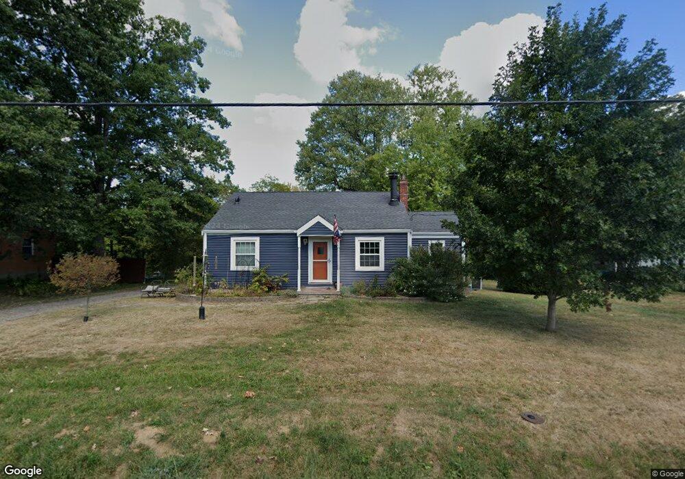
666 Skyway Dr Independence, KY 41051
Estimated Value: $179,000 - $230,000
3
Beds
1
Bath
1,218
Sq Ft
$177/Sq Ft
Est. Value
About This Home
This home is located at 666 Skyway Dr, Independence, KY 41051 and is currently estimated at $215,496, approximately $176 per square foot. 666 Skyway Dr is a home located in Kenton County with nearby schools including White's Tower Elementary School, Twenhofel Middle School, and Simon Kenton High School.
Ownership History
Date
Name
Owned For
Owner Type
Purchase Details
Closed on
Jul 31, 2012
Sold by
Soward Terry L and Rohlman Vickie
Bought by
Mullins Damien and Cowan Barbara
Current Estimated Value
Home Financials for this Owner
Home Financials are based on the most recent Mortgage that was taken out on this home.
Original Mortgage
$77,123
Interest Rate
3.53%
Mortgage Type
VA
Purchase Details
Closed on
Mar 14, 2008
Sold by
Soward Sherry L
Bought by
Soward Terry L
Create a Home Valuation Report for This Property
The Home Valuation Report is an in-depth analysis detailing your home's value as well as a comparison with similar homes in the area
Home Values in the Area
Average Home Value in this Area
Purchase History
| Date | Buyer | Sale Price | Title Company |
|---|---|---|---|
| Mullins Damien | $75,500 | Vantage Land Title | |
| Soward Terry L | -- | None Available |
Source: Public Records
Mortgage History
| Date | Status | Borrower | Loan Amount |
|---|---|---|---|
| Previous Owner | Mullins Damien | $77,123 |
Source: Public Records
Tax History
| Year | Tax Paid | Tax Assessment Tax Assessment Total Assessment is a certain percentage of the fair market value that is determined by local assessors to be the total taxable value of land and additions on the property. | Land | Improvement |
|---|---|---|---|---|
| 2025 | $1,996 | $171,600 | $30,000 | $141,600 |
| 2024 | $1,087 | $88,700 | $25,000 | $63,700 |
| 2023 | $1,119 | $88,700 | $25,000 | $63,700 |
| 2022 | $1,188 | $88,700 | $25,000 | $63,700 |
| 2021 | $1,205 | $88,700 | $25,000 | $63,700 |
| 2020 | $1,057 | $75,500 | $25,000 | $50,500 |
| 2019 | $1,060 | $75,500 | $25,000 | $50,500 |
| 2018 | $1,065 | $75,500 | $25,000 | $50,500 |
| 2017 | $1,038 | $75,500 | $25,000 | $50,500 |
| 2015 | $1,000 | $75,500 | $25,000 | $50,500 |
| 2014 | $987 | $75,500 | $25,000 | $50,500 |
Source: Public Records
Map
Nearby Homes
- 685 Skyway Dr
- 692 Sycamore Dr
- 718 Willow Green Dr
- 714 Willow Green Dr
- 3118 Belleglade Dr
- 712 Lakefield Dr
- 765 Jimae Ave
- 3135 Chipping Camden
- 798 Cox Rd
- 3044 Belleglade Dr
- 3056 Belleglade Dr
- 5510 Fowler Creek Rd
- 789 Stonybrook Ct
- 798 Stonybrook Ct
- 6681 Tullamore Ln Unit Lot 3
- 6703 Tullamore Ln Unit Lot 7
- 6296 Taylor Mill Rd
- 772 Durrow Dr Unit Lot 26
- 6519 Meadow Creek Dr
- 6409 Stonemill Dr
Your Personal Tour Guide
Ask me questions while you tour the home.