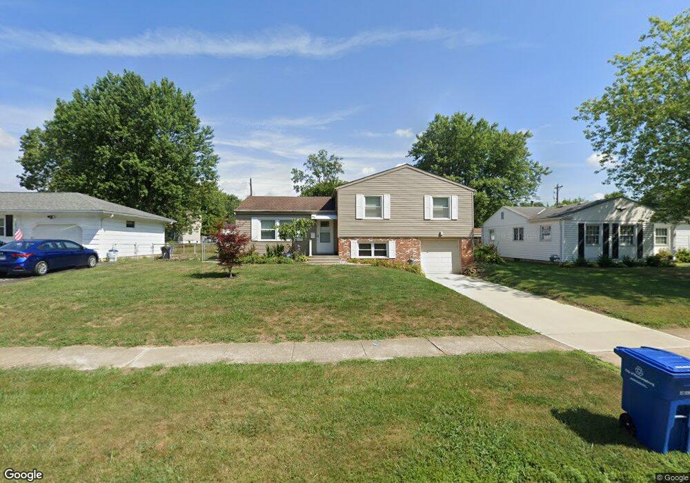
6670 Rocky Den Rd Reynoldsburg, OH 43068
Estimated Value: $253,527 - $301,000
3
Beds
2
Baths
1,620
Sq Ft
$171/Sq Ft
Est. Value
About This Home
This home is located at 6670 Rocky Den Rd, Reynoldsburg, OH 43068 and is currently estimated at $277,632, approximately $171 per square foot. 6670 Rocky Den Rd is a home located in Franklin County with nearby schools including Rose Hill Elementary School, Waggoner Road Elementary School, and Waggoner Road Junior High School.
Ownership History
Date
Name
Owned For
Owner Type
Purchase Details
Closed on
Oct 27, 2010
Sold by
Corwin Elizabeth
Bought by
Mansfield Barbara J
Current Estimated Value
Home Financials for this Owner
Home Financials are based on the most recent Mortgage that was taken out on this home.
Original Mortgage
$119,392
Outstanding Balance
$78,693
Interest Rate
4.25%
Mortgage Type
FHA
Estimated Equity
$198,939
Purchase Details
Closed on
Oct 18, 2002
Sold by
Corwin Roger and Corwin Elizabeth
Bought by
Corwin Roger and Corwin Elizabeth
Purchase Details
Closed on
Jul 24, 1995
Sold by
Lynch Kenneth L
Bought by
Corwin Roger and Corwin Elizabeth
Purchase Details
Closed on
Sep 16, 1987
Create a Home Valuation Report for This Property
The Home Valuation Report is an in-depth analysis detailing your home's value as well as a comparison with similar homes in the area
Home Values in the Area
Average Home Value in this Area
Purchase History
| Date | Buyer | Sale Price | Title Company |
|---|---|---|---|
| Mansfield Barbara J | -- | Fati | |
| Corwin Roger | -- | -- | |
| Corwin Roger | $94,700 | -- | |
| -- | $66,900 | -- |
Source: Public Records
Mortgage History
| Date | Status | Borrower | Loan Amount |
|---|---|---|---|
| Open | Mansfield Barbara J | $119,392 |
Source: Public Records
Tax History Compared to Growth
Tax History
| Year | Tax Paid | Tax Assessment Tax Assessment Total Assessment is a certain percentage of the fair market value that is determined by local assessors to be the total taxable value of land and additions on the property. | Land | Improvement |
|---|---|---|---|---|
| 2024 | $3,753 | $73,300 | $26,080 | $47,220 |
| 2023 | $3,582 | $73,290 | $26,075 | $47,215 |
| 2022 | $3,032 | $46,940 | $13,200 | $33,740 |
| 2021 | $3,044 | $46,940 | $13,200 | $33,740 |
| 2020 | $3,105 | $46,940 | $13,200 | $33,740 |
| 2019 | $2,853 | $39,100 | $10,990 | $28,110 |
| 2018 | $2,887 | $39,100 | $10,990 | $28,110 |
| 2017 | $2,934 | $39,100 | $10,990 | $28,110 |
| 2016 | $3,014 | $36,930 | $7,810 | $29,120 |
| 2015 | $2,921 | $36,930 | $7,810 | $29,120 |
| 2014 | $2,934 | $36,930 | $7,810 | $29,120 |
| 2013 | $1,503 | $38,885 | $8,225 | $30,660 |
Source: Public Records
Map
Nearby Homes
- 6737 Rocky Den Rd
- 6700 Helm Ln
- 6563 Helm Ave
- 6564 Red Fox Rd
- 6810 Prior Place
- 6526 Borr Ave
- 6849 Roundelay Rd N
- 6609 Fusilier Ave
- 0 Rosehill Rd
- 6890 Nocturne Rd N
- 622 Brice Rd
- 6442 Borr Ave
- 6600 Carriage Ln
- 664 Bainbrook Ct
- 6599 Carriage Ln
- 847 Promise Ct
- 857 Promise Ct
- 6930 Tanya Terrace
- 6568 Shenandoah Dr
- 6258 Peach Tree Rd
- 6662 Rocky Den Rd
- 6680 Rocky Den Rd
- 6673 Helm Ave
- 6652 Rocky Den Rd
- 6690 Rocky Den Rd
- 6683 Helm Ave
- 6665 Helm Ave
- 6693 Ravenna Ct
- 6679 Rocky Den Rd
- 6669 Rocky Den Rd
- 6642 Rocky Den Rd
- 6659 Rocky Den Rd
- 6701 Ravenna Ct
- 6655 Helm Ave
- 6689 Rocky Den Rd
- 6647 Rocky Den Rd
- 6699 Rocky Den Rd
- 6711 Ravenna Ct
- 6634 Rocky Den Rd
- 6710 Rocky Den Rd