Estimated Value: $229,000 - $328,999
4
Beds
2
Baths
2,056
Sq Ft
$142/Sq Ft
Est. Value
About This Home
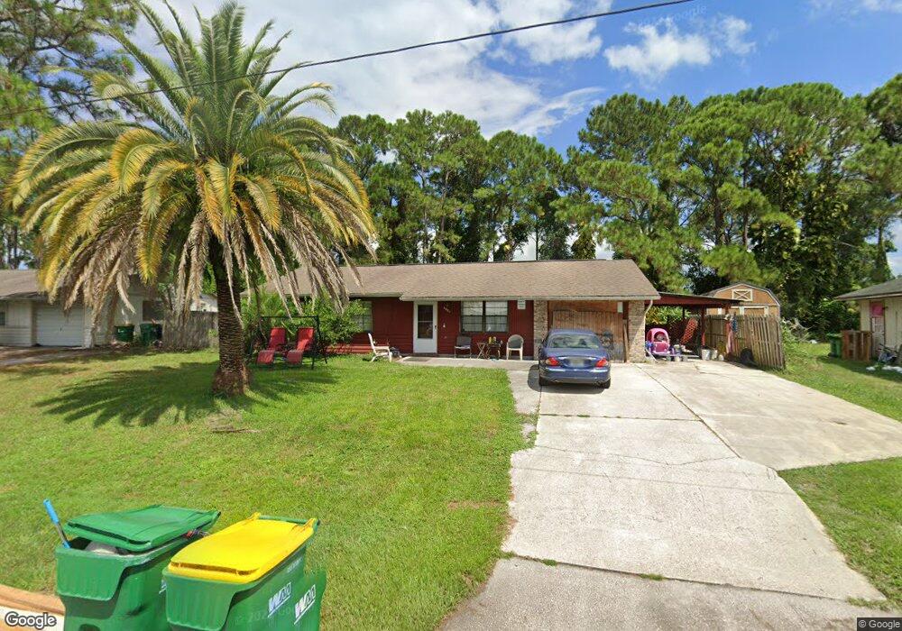
This home is located at 6681 Cecil Rd, Cocoa, FL 32927 and is currently estimated at $292,500, approximately $142 per square foot. 6681 Cecil Rd is a home located in Brevard County with nearby schools including Enterprise Elementary School, Space Coast Junior/Senior High School, and Sculptor Charter School.
Ownership History
Date
Name
Owned For
Owner Type
Purchase Details
Closed on
Dec 16, 2009
Sold by
Secretary Of The Department Of Veterans
Bought by
Kyro Elaine Psomiades and Kyro Jonathan Jay
Current Estimated Value
Purchase Details
Closed on
Jun 30, 2009
Sold by
Odorich Donold J and Jpmorgan Chase Bank Na
Bought by
Secretary Of Department Of Veterans Affa
Purchase Details
Closed on
Aug 11, 2004
Sold by
Larson Wayne A and Larson Susan Lynn
Bought by
Odorich Donold J
Home Financials for this Owner
Home Financials are based on the most recent Mortgage that was taken out on this home.
Original Mortgage
$163,400
Interest Rate
5.96%
Create a Home Valuation Report for This Property
The Home Valuation Report is an in-depth analysis detailing your home's value as well as a comparison with similar homes in the area
Home Values in the Area
Average Home Value in this Area
Purchase History
| Date | Buyer | Sale Price | Title Company |
|---|---|---|---|
| Kyro Elaine Psomiades | $70,000 | Attorney | |
| Secretary Of Department Of Veterans Affa | -- | Attorney | |
| Odorich Donold J | $163,400 | Gulfatlantic Title |
Source: Public Records
Mortgage History
| Date | Status | Borrower | Loan Amount |
|---|---|---|---|
| Previous Owner | Odorich Donold J | $163,400 |
Source: Public Records
Tax History
| Year | Tax Paid | Tax Assessment Tax Assessment Total Assessment is a certain percentage of the fair market value that is determined by local assessors to be the total taxable value of land and additions on the property. | Land | Improvement |
|---|---|---|---|---|
| 2025 | $1,077 | $85,280 | -- | -- |
| 2024 | $1,044 | $82,880 | -- | -- |
| 2023 | $1,044 | $80,470 | $0 | $0 |
| 2022 | $966 | $78,130 | $0 | $0 |
| 2021 | $956 | $75,860 | $0 | $0 |
| 2020 | $917 | $74,820 | $0 | $0 |
| 2019 | $865 | $73,140 | $0 | $0 |
| 2018 | $868 | $71,780 | $0 | $0 |
| 2017 | $873 | $70,310 | $0 | $0 |
| 2016 | $881 | $68,870 | $18,000 | $50,870 |
| 2015 | $890 | $68,400 | $15,000 | $53,400 |
| 2014 | $895 | $67,860 | $11,000 | $56,860 |
Source: Public Records
Map
Nearby Homes
- 6760 Cairo Rd
- 5095 Hogan Place
- 00 Unknown
- 6815 Bryant Rd
- 6450 Ember Ave
- 6620 Grissom Pkwy
- 6615 Dock Ave
- 0000 Grissom Pkwy
- 5155 Mayflower St
- 6375 Cable Ave
- 7065 Hundred Acre Dr
- 4852 Alfred St
- 5165 Patricia St
- 6581 Bancroft Ave
- 5080 Mayflower St
- 6990 Bryant Rd
- 5555 Brandon St
- 4790 Greenhill St
- 6481 La Brea Ave
- 5220 Holden Rd
- 6673 Cecil Rd
- 6665 Cecil Rd
- 5220 Curtis Blvd
- 6680 Cecil Rd
- 5210 Curtis Blvd
- 6670 Cecil Rd
- 5230 Curtis Blvd
- 6690 Cecil Rd
- 5200 Curtis Blvd
- 5240 Curtis Blvd
- 6657 Cecil Rd
- 6660 Cecil Rd
- 6713 Cecil Rd Unit 7
- 6713 Cecil Rd
- 6712 Cecil Rd
- 5190 Curtis Blvd
- 5250 Curtis Blvd
- 6695 Cairo Rd
- 6650 Cecil Rd
- 6715 Cairo Rd
Your Personal Tour Guide
Ask me questions while you tour the home.