67 Ashland St Malden, MA 02148
Belmont NeighborhoodEstimated Value: $1,091,000 - $2,198,000
About This Home
1 - 2 months. 2 bedroom 1-1/2 bath furnished apartment . No broker fee.
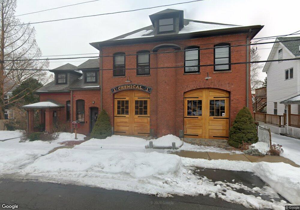
Character and history abound in this utterly charming duplex furnished apartment, in metro Boston near Logan Airport. Awarded for outstanding achievement in historic preservation, the apartment has been completely renovated with loving care, incorporating architectural details and décor that hark back to the building’s rich history as a firehouse. The rooms are chock full of nooks and crannies and charm galore. The gleaming hardwood floors and 11 foot ceilings give an airy, spacious feel as a family friendly vacation rental for Boston visitors. The open concept first floor features a fully equipped kitchen with beautiful wood cabinets and a living room area with flat screen TV and desk area perfect for computer time. There is also a ½ bath and a full bed in a corner away from the living room area. The second floor has two bedrooms and a full bath with claw foot tub with shower. The two-floor apartment has two bedrooms and one and a half baths, accommodating up to six guests. Central air keeps you comfortable in summer, and environmentalists will appreciate the solar heated water and eco-friendly products. Located close to biking and hiking trails, playgrounds and state parks (bike storage provided). 4 blocks to the bus or 20 minute walk to public transit, or drive and park to another metro in 10-15 minutes. All take you Boston’s historic sites, Tufts University and MIT. History buffs will delight. (Note: stairs to bedrooms are a little steep.) Off street parking for one car. No street parking.
Ownership History
Purchase Details
Home Financials for this Owner
Home Financials are based on the most recent Mortgage that was taken out on this home.Home Values in the Area
Average Home Value in this Area
Purchase History
| Date | Buyer | Sale Price | Title Company |
|---|---|---|---|
| Beckemeier Jonathan | $160,000 | -- |
Mortgage History
| Date | Status | Borrower | Loan Amount |
|---|---|---|---|
| Open | Beckemeier Jonathan | $300,000 |
Property History
| Date | Event | Price | List to Sale | Price per Sq Ft |
|---|---|---|---|---|
| 10/08/2024 10/08/24 | Off Market | $3,300 | -- | -- |
| 11/04/2021 11/04/21 | For Rent | $3,300 | -- | -- |
Tax History Compared to Growth
Tax History
| Year | Tax Paid | Tax Assessment Tax Assessment Total Assessment is a certain percentage of the fair market value that is determined by local assessors to be the total taxable value of land and additions on the property. | Land | Improvement |
|---|---|---|---|---|
| 2025 | $134 | $1,180,600 | $360,300 | $820,300 |
| 2024 | $13,411 | $1,147,200 | $340,300 | $806,900 |
| 2023 | $12,295 | $1,008,600 | $310,200 | $698,400 |
| 2022 | $11,792 | $954,800 | $280,200 | $674,600 |
| 2021 | $11,366 | $924,800 | $250,200 | $674,600 |
| 2020 | $10,754 | $850,100 | $241,700 | $608,400 |
| 2019 | $10,474 | $789,300 | $230,200 | $559,100 |
| 2018 | $10,277 | $729,400 | $190,100 | $539,300 |
| 2017 | $11,082 | $782,100 | $182,600 | $599,500 |
| 2016 | $6,629 | $437,300 | $167,600 | $269,700 |
| 2015 | $6,462 | $410,800 | $159,600 | $251,200 |
| 2014 | $6,134 | $381,000 | $145,100 | $235,900 |
Map
- 72 Ashland St Unit 307
- 89 Judson St
- 17 Garland Ave
- 4 Cross St Unit 1
- 23 Pratt St
- 15-17 Barrett St
- 44 Stevens St
- 80 Main St Unit 9
- 55 Clarendon St
- 23 Upham St
- 13-15 Benner Ave
- 28 Shawmut St
- 16 Boylston St
- 74 Madison St
- 67 Converse Ave Unit 69
- 153A Belmont St
- 100 Medford St
- 210 Hancock St
- 58 Regent Rd
- 98 Bradford St
- 63 Ashland St Unit 65
- 63 Ashland St Unit 1
- 67 Ashland St Unit Firehouse
- 65 Ashland St
- 65 Ashland St Unit 2
- 65 Ashland St Unit 65
- 61 Ashland St
- 61 Ashland St Unit 2
- 61 Ashland St Unit 1
- 77 Ashland St Unit 79
- 77 Ashland St Unit 1
- 59 Ashland St
- 59 Ashland St Unit 1
- 59 Ashland St Unit 59
- 104 High St
- 55 Ashland St Unit 57
- 2 Fuller St
- 60 Ashland St
- 72 Ashland St Unit 410
- 72 Ashland St Unit 409