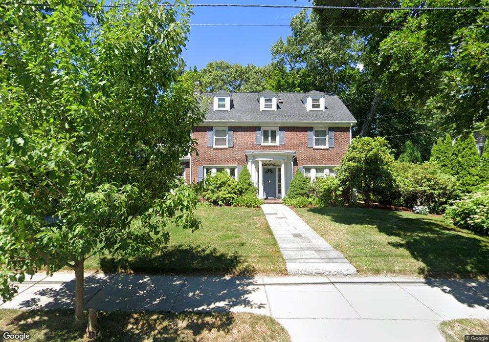
67 Beaumont Ave Newtonville, MA 02460
Newtonville NeighborhoodEstimated Value: $1,870,000 - $2,180,000
4
Beds
4
Baths
2,890
Sq Ft
$692/Sq Ft
Est. Value
About This Home
This home is located at 67 Beaumont Ave, Newtonville, MA 02460 and is currently estimated at $1,999,042, approximately $691 per square foot. 67 Beaumont Ave is a home located in Middlesex County with nearby schools including Cabot Elementary School, F.A. Day Middle School, and Newton North High School.
Ownership History
Date
Name
Owned For
Owner Type
Purchase Details
Closed on
Apr 14, 1994
Sold by
Beaumont Rt and Coppola Mark D
Bought by
Katz Jill A
Current Estimated Value
Purchase Details
Closed on
Oct 29, 1993
Sold by
Est Gallagher Marie L and Gallagher James F
Bought by
Beaumont Rt and Coppola Mark D
Home Financials for this Owner
Home Financials are based on the most recent Mortgage that was taken out on this home.
Original Mortgage
$320,000
Interest Rate
6.86%
Mortgage Type
Purchase Money Mortgage
Create a Home Valuation Report for This Property
The Home Valuation Report is an in-depth analysis detailing your home's value as well as a comparison with similar homes in the area
Home Values in the Area
Average Home Value in this Area
Purchase History
| Date | Buyer | Sale Price | Title Company |
|---|---|---|---|
| Katz Jill A | $560,000 | -- | |
| Beaumont Rt | $325,000 | -- |
Source: Public Records
Mortgage History
| Date | Status | Borrower | Loan Amount |
|---|---|---|---|
| Open | Beaumont Rt | $417,000 | |
| Closed | Beaumont Rt | $200,000 | |
| Previous Owner | Beaumont Rt | $320,000 |
Source: Public Records
Tax History Compared to Growth
Tax History
| Year | Tax Paid | Tax Assessment Tax Assessment Total Assessment is a certain percentage of the fair market value that is determined by local assessors to be the total taxable value of land and additions on the property. | Land | Improvement |
|---|---|---|---|---|
| 2025 | $16,426 | $1,676,100 | $1,144,000 | $532,100 |
| 2024 | $15,882 | $1,627,300 | $1,110,700 | $516,600 |
| 2023 | $15,144 | $1,487,600 | $839,100 | $648,500 |
| 2022 | $14,490 | $1,377,400 | $776,900 | $600,500 |
| 2021 | $13,982 | $1,299,400 | $732,900 | $566,500 |
| 2020 | $13,627 | $1,305,300 | $732,900 | $572,400 |
| 2019 | $13,243 | $1,267,300 | $711,600 | $555,700 |
| 2018 | $12,883 | $1,190,700 | $649,800 | $540,900 |
| 2017 | $12,491 | $1,123,300 | $613,000 | $510,300 |
| 2016 | $11,947 | $1,049,800 | $572,900 | $476,900 |
| 2015 | $11,391 | $981,100 | $535,400 | $445,700 |
Source: Public Records
Map
Nearby Homes
- 61 Lakeview Ave
- 308 Prince St
- 34 Morton Rd
- 887 Commonwealth Ave
- 22 Walnut Place Unit 1
- 123-125 Mount Vernon St
- 123 Mount Vernon St Unit 2
- 39 Valentine Park
- 300 Cabot St
- 3 Cedar St
- 957 Washington St Unit 1
- 935 Washington St Unit 8
- 911 Washington St
- 318 Austin St Unit A
- 127-129 Withington Rd Unit 1
- 12 Wiswall St
- 4 Wiswall St
- 54 Garland Rd
- 10 Washington Park
- 10 Washington Park Unit 2
- 61 Beaumont Ave
- 77 Beaumont Ave
- 458 Lowell Ave Unit 460
- 454 Lowell Ave
- 454 Lowell Ave Unit 454
- 452 Lowell Ave Unit 1
- 450 Lowell Ave Unit 452
- 450 Lowell Ave Unit 2
- 446-448 Lowell Ave Unit 448
- 456 Lowell Ave
- 446 Lowell Ave Unit 448
- 446 Lowell Ave Unit 446
- 446 Lowell Ave
- 446 Lowell Ave Unit 1
- 446 Lowell Ave Unit 2
- 448 Lowell Ave Unit 2
- 466 Lowell Ave
- 66 Beaumont Ave
- 51 Beaumont Ave
- 442 Lowell Ave Unit 444