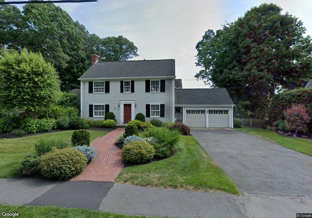
67 Clarke Rd Needham, MA 02492
Estimated Value: $1,234,000 - $1,911,000
4
Beds
3
Baths
1,597
Sq Ft
$1,006/Sq Ft
Est. Value
About This Home
This home is located at 67 Clarke Rd, Needham, MA 02492 and is currently estimated at $1,606,908, approximately $1,006 per square foot. 67 Clarke Rd is a home located in Norfolk County with nearby schools including Sunita L. Williams Elementary School, High Rock Middle School, and Pollard Middle School.
Ownership History
Date
Name
Owned For
Owner Type
Purchase Details
Closed on
Apr 10, 2025
Sold by
Jacob Deborah H
Bought by
Deborah Anne H Jacob T and Deborah Jacob
Current Estimated Value
Purchase Details
Closed on
Apr 23, 2004
Sold by
Jacob Deborah H
Bought by
Hunter-Jacob Deborah and Hunter-Jacob Thomas J
Purchase Details
Closed on
Jan 27, 1994
Sold by
Lenahan Mary K and Lenahan Mary M
Bought by
Jacob Thomas M and Jacob Deborah H
Create a Home Valuation Report for This Property
The Home Valuation Report is an in-depth analysis detailing your home's value as well as a comparison with similar homes in the area
Home Values in the Area
Average Home Value in this Area
Purchase History
| Date | Buyer | Sale Price | Title Company |
|---|---|---|---|
| Deborah Anne H Jacob T | -- | None Available | |
| Hunter-Jacob Deborah | -- | -- | |
| Hunter-Jacob Deborah | -- | -- | |
| Jacob Thomas M | $330,000 | -- | |
| Jacob Thomas M | $330,000 | -- |
Source: Public Records
Mortgage History
| Date | Status | Borrower | Loan Amount |
|---|---|---|---|
| Previous Owner | Jacob Thomas M | $370,000 | |
| Previous Owner | Jacob Thomas M | $373,000 |
Source: Public Records
Tax History
| Year | Tax Paid | Tax Assessment Tax Assessment Total Assessment is a certain percentage of the fair market value that is determined by local assessors to be the total taxable value of land and additions on the property. | Land | Improvement |
|---|---|---|---|---|
| 2025 | $16,310 | $1,538,700 | $1,097,000 | $441,700 |
| 2024 | $13,791 | $1,101,500 | $613,100 | $488,400 |
| 2023 | $13,811 | $1,059,100 | $613,100 | $446,000 |
| 2022 | $13,310 | $995,500 | $568,100 | $427,400 |
| 2021 | $12,971 | $995,500 | $568,100 | $427,400 |
| 2020 | $12,796 | $1,024,500 | $568,100 | $456,400 |
| 2019 | $11,935 | $963,300 | $517,000 | $446,300 |
| 2018 | $11,444 | $963,300 | $517,000 | $446,300 |
| 2017 | $10,821 | $910,100 | $517,000 | $393,100 |
| 2016 | $10,552 | $914,400 | $517,000 | $397,400 |
| 2015 | $10,324 | $914,400 | $517,000 | $397,400 |
| 2014 | $9,949 | $854,700 | $470,500 | $384,200 |
Source: Public Records
Map
Nearby Homes
- 102 Jarvis Cir Unit 102
- 70 Briarwood Cir
- 36 Eliot Rd
- 81 Parish Rd
- 15 Mackintosh Ave
- 34 Pershing Rd
- 19 Mason Rd
- 12 Hill St
- 3 Hancock Rd
- 48 Taylor St
- 37 Standish Rd
- 52 Hancock Rd
- 151 Oakland St
- 21 Brewster Dr
- 15 Alden Rd
- 3 Crescent Rd
- 379 Hunnewell St Unit 379
- 100 Rosemary Way Unit 129
- 385 Hillside Ave
- 385 Hillside Ave Unit 385
Your Personal Tour Guide
Ask me questions while you tour the home.