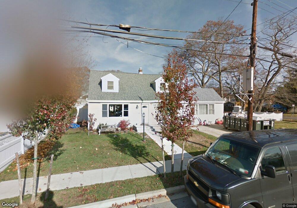
67 Connecticut Ave Massapequa, NY 11758
Estimated Value: $788,082 - $873,000
--
Bed
3
Baths
2,152
Sq Ft
$386/Sq Ft
Est. Value
About This Home
This home is located at 67 Connecticut Ave, Massapequa, NY 11758 and is currently estimated at $830,541, approximately $385 per square foot. 67 Connecticut Ave is a home located in Nassau County with nearby schools including Massapequa High School - Ames Campus, Berner Middle School, and Massapequa High School.
Ownership History
Date
Name
Owned For
Owner Type
Purchase Details
Closed on
Aug 20, 2014
Sold by
Comerford Coleen and Comerford John
Bought by
Comerford Coleen
Current Estimated Value
Purchase Details
Closed on
Jan 14, 2010
Sold by
Nilsen Barbara
Bought by
Comerford John
Home Financials for this Owner
Home Financials are based on the most recent Mortgage that was taken out on this home.
Original Mortgage
$250,000
Interest Rate
4.83%
Mortgage Type
Purchase Money Mortgage
Purchase Details
Closed on
Jul 24, 1995
Sold by
Young Charles and Young Katherine
Bought by
Nilsen Barbara
Create a Home Valuation Report for This Property
The Home Valuation Report is an in-depth analysis detailing your home's value as well as a comparison with similar homes in the area
Home Values in the Area
Average Home Value in this Area
Purchase History
| Date | Buyer | Sale Price | Title Company |
|---|---|---|---|
| Comerford Coleen | -- | New York Title | |
| Comerford John | $355,000 | -- | |
| Nilsen Barbara | -- | -- |
Source: Public Records
Mortgage History
| Date | Status | Borrower | Loan Amount |
|---|---|---|---|
| Previous Owner | Comerford John | $250,000 |
Source: Public Records
Tax History Compared to Growth
Tax History
| Year | Tax Paid | Tax Assessment Tax Assessment Total Assessment is a certain percentage of the fair market value that is determined by local assessors to be the total taxable value of land and additions on the property. | Land | Improvement |
|---|---|---|---|---|
| 2025 | $13,914 | $522 | $206 | $316 |
| 2024 | $5,017 | $583 | $230 | $353 |
| 2023 | $14,491 | $583 | $230 | $353 |
| 2022 | $14,491 | $583 | $230 | $353 |
| 2021 | $14,265 | $562 | $222 | $340 |
| 2020 | $13,875 | $818 | $523 | $295 |
| 2019 | $13,222 | $991 | $634 | $357 |
| 2018 | $15,049 | $991 | $0 | $0 |
| 2017 | $8,401 | $991 | $634 | $357 |
| 2016 | $13,222 | $991 | $634 | $357 |
| 2015 | $4,327 | $991 | $634 | $357 |
| 2014 | $4,327 | $991 | $634 | $357 |
| 2013 | $3,756 | $946 | $634 | $312 |
Source: Public Records
Map
Nearby Homes
- 70 Pittsburgh Ave
- 11 Pittsburgh Ave
- 51 Michigan Ave
- 20 Boston Ave
- 36 Michigan Ave
- 102 Boston Ave
- 73 Massachusetts Ave
- 63 Pennsylvania Ave
- 104 Clark Ave
- 22 Commonwealth Ave
- 128 Massachusetts Ave
- 126 Commonwealth Ave
- 136 Euclid Ave
- 76 Hamilton Ave
- 121 Ontario Ave
- 101 Toronto Ave
- 1872 Park Dr
- 163 Massachusetts Ave
- 4037 Park Dr
- 3970 Worthmor Dr
- 589 Hicksville Rd
- 65 Connecticut Ave
- 68 Euclid Ave
- 66 Connecticut Ave
- 585 Hicksville Rd
- 66 Euclid Ave
- 592 Hicksville Rd
- 64 Connecticut Ave
- 588 Hicksville Rd
- 59 Connecticut Ave
- 68 Connecticut Ave
- 70 Euclid Ave
- 64 Euclid Ave
- 582 Hicksville Rd
- 581 Hicksville Rd
- 61 Chicago Ave
- 595 Hicksville Rd
- 72 Euclid Ave
- 71 Connecticut Ave
- 60 Connecticut Ave