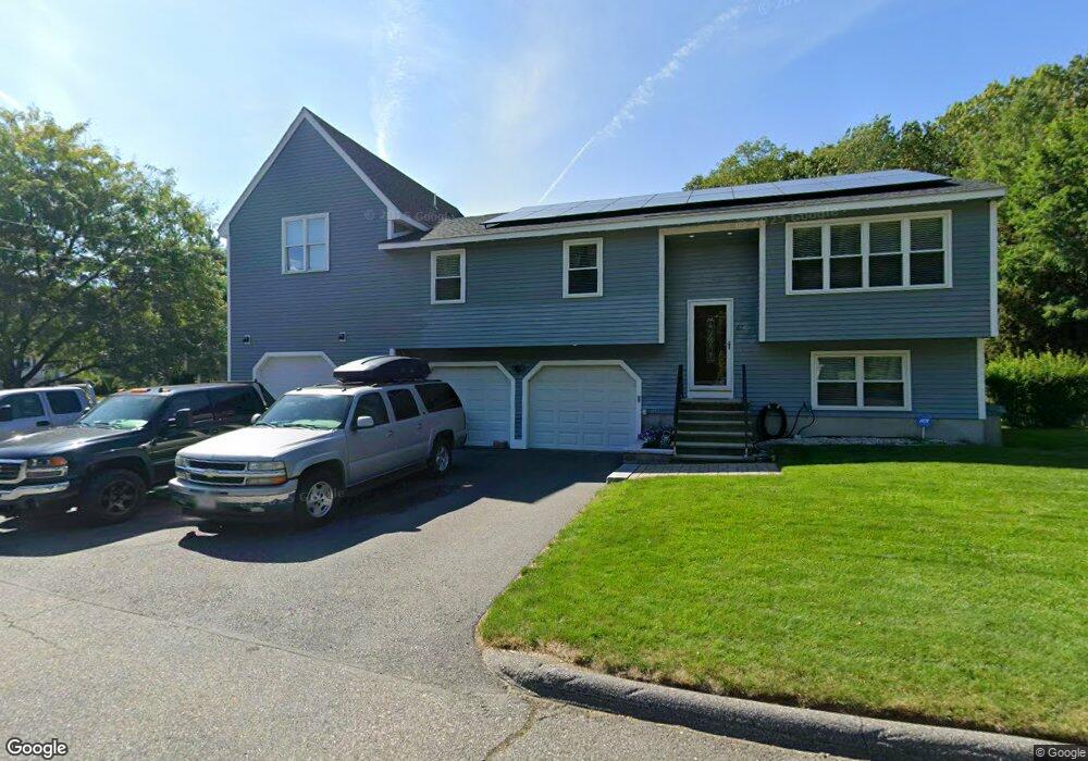
67 Crisci St Leominster, MA 01453
Estimated Value: $505,000 - $596,000
4
Beds
2
Baths
1,306
Sq Ft
$420/Sq Ft
Est. Value
About This Home
This home is located at 67 Crisci St, Leominster, MA 01453 and is currently estimated at $549,137, approximately $420 per square foot. 67 Crisci St is a home located in Worcester County with nearby schools including Leominster High School, St. Anna Catholic School, and St. Leo School.
Ownership History
Date
Name
Owned For
Owner Type
Purchase Details
Closed on
Feb 11, 2011
Sold by
Ban Gerard C and Ban Martha F
Bought by
Yoder Renee
Current Estimated Value
Home Financials for this Owner
Home Financials are based on the most recent Mortgage that was taken out on this home.
Original Mortgage
$204,250
Outstanding Balance
$140,425
Interest Rate
4.88%
Mortgage Type
Purchase Money Mortgage
Estimated Equity
$408,712
Purchase Details
Closed on
Feb 24, 2000
Sold by
Keyes Michael H
Bought by
Ban Gerard C and Ban Martha F
Home Financials for this Owner
Home Financials are based on the most recent Mortgage that was taken out on this home.
Original Mortgage
$113,000
Interest Rate
8.15%
Mortgage Type
Purchase Money Mortgage
Purchase Details
Closed on
May 30, 1997
Sold by
Mele Matthew and Mele Sharon L
Bought by
Keyes Michael H
Home Financials for this Owner
Home Financials are based on the most recent Mortgage that was taken out on this home.
Original Mortgage
$131,478
Interest Rate
8.09%
Mortgage Type
Purchase Money Mortgage
Create a Home Valuation Report for This Property
The Home Valuation Report is an in-depth analysis detailing your home's value as well as a comparison with similar homes in the area
Home Values in the Area
Average Home Value in this Area
Purchase History
| Date | Buyer | Sale Price | Title Company |
|---|---|---|---|
| Yoder Renee | $215,000 | -- | |
| Ban Gerard C | $143,000 | -- | |
| Keyes Michael H | $128,900 | -- |
Source: Public Records
Mortgage History
| Date | Status | Borrower | Loan Amount |
|---|---|---|---|
| Open | Yoder Renee | $204,250 | |
| Previous Owner | Keyes Michael H | $112,900 | |
| Previous Owner | Keyes Michael H | $113,000 | |
| Previous Owner | Keyes Michael H | $131,478 | |
| Previous Owner | Keyes Michael H | $120,000 |
Source: Public Records
Tax History Compared to Growth
Tax History
| Year | Tax Paid | Tax Assessment Tax Assessment Total Assessment is a certain percentage of the fair market value that is determined by local assessors to be the total taxable value of land and additions on the property. | Land | Improvement |
|---|---|---|---|---|
| 2025 | $6,649 | $473,900 | $137,600 | $336,300 |
| 2024 | $6,460 | $445,200 | $131,000 | $314,200 |
| 2023 | $5,697 | $366,600 | $113,900 | $252,700 |
| 2022 | $5,432 | $328,000 | $99,000 | $229,000 |
| 2021 | $5,231 | $288,500 | $77,100 | $211,400 |
| 2020 | $5,074 | $282,200 | $77,100 | $205,100 |
| 2019 | $4,859 | $262,100 | $73,400 | $188,700 |
| 2018 | $4,921 | $254,600 | $71,300 | $183,300 |
| 2017 | $4,463 | $226,200 | $66,600 | $159,600 |
| 2016 | $4,218 | $215,400 | $66,600 | $148,800 |
| 2015 | $4,080 | $209,900 | $66,600 | $143,300 |
| 2014 | $4,024 | $213,000 | $72,600 | $140,400 |
Source: Public Records
Map
Nearby Homes
- 93 Chapman Place Unit 93
- 57 Chapman Place
- 177 Chapman Place
- 197 Chapman Place Unit 197
- 556 Central St Unit 43
- 556 Central St Unit 39
- 36 Meadow Pond Dr Unit I
- 399 Union St
- 30 Abbey Rd Unit 207
- 10 Abbey Rd Unit 108
- 30 Abbey Rd Unit 202
- 10 Abbey Rd Unit 205
- 45 Tisdale St
- 740 Central St Unit R24
- 740 Central St Unit L22
- 91 Eugene St
- 104 Sylvan Ave
- 98 Sylvan Ave
- 315 Grant St
- 6 Longwood Ave