
Seller's Agent in 2025
Dave Fairty
E.J. Murphy Realty
(860) 945-9868
2 in this area
59 Total Sales
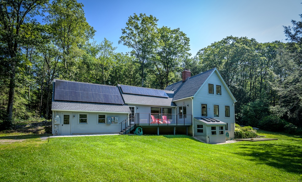
Turn-Key Woodland Retreat. This fully modernized two-bedroom, four-bath Cape-style home offers the perfect blend of privacy, efficiency, and natural beauty. Set on 7.5 secluded acres and abutting nearly 830 acres of pristine conservation land, the property provides unmatched peace and direct access to nature. Completely renovated from top to bottom, this turnkey home features all-new mechanical systems, an owned solar array that runs the whole house with positive returns, and a sleek, modern aesthetic throughout. There is a whole house generator with buried 500 gallon propane tank. The spacious layout includes multiple living areas, generous bedrooms, and updated baths, offering comfort and flexibility for today's lifestyle. Enjoy low Warren taxes and deeded lake rights to nearby Lake Waramaug-ideal for swimming, boating, and year-round recreation. Whether you're looking for a full-time residence or a country retreat, this property is a rare find. Don't miss this one!
Last Agent to Sell the Property
E.J. Murphy Realty Brokerage Phone: (203) 788-7926 License #RES.0800404 Listed on: 08/12/2025
| Date | Type | Sale Price | Title Company |
|---|---|---|---|
| Warranty Deed | $900,000 | -- | |
| Warranty Deed | $250,000 | -- | |
| Warranty Deed | $250,000 | -- |
| Date | Status | Loan Amount | Loan Type |
|---|---|---|---|
| Open | $805,000 | Purchase Money Mortgage | |
| Previous Owner | $225,000 | New Conventional | |
| Previous Owner | $106,119 | No Value Available | |
| Previous Owner | $132,000 | No Value Available |
| Date | Event | Price | List to Sale | Price per Sq Ft |
|---|---|---|---|---|
| 10/16/2025 10/16/25 | Sold | $900,000 | -5.3% | $319 / Sq Ft |
| 10/03/2025 10/03/25 | Pending | -- | -- | -- |
| 08/12/2025 08/12/25 | For Sale | $950,000 | -- | $337 / Sq Ft |
| Year | Tax Paid | Tax Assessment Tax Assessment Total Assessment is a certain percentage of the fair market value that is determined by local assessors to be the total taxable value of land and additions on the property. | Land | Improvement |
|---|---|---|---|---|
| 2025 | $3,128 | $245,350 | $73,080 | $172,270 |
| 2024 | $3,128 | $245,350 | $73,080 | $172,270 |
| 2023 | $3,226 | $245,350 | $73,080 | $172,270 |
| 2022 | $2,503 | $176,860 | $73,100 | $103,760 |
| 2021 | $2,503 | $176,860 | $73,100 | $103,760 |
| 2020 | $2,520 | $176,860 | $73,100 | $103,760 |
| 2019 | $2,520 | $176,860 | $73,100 | $103,760 |
| 2018 | $2,520 | $176,860 | $73,100 | $103,760 |
| 2017 | $2,990 | $206,240 | $80,940 | $125,300 |
| 2016 | $2,960 | $206,240 | $80,940 | $125,300 |
| 2015 | $2,929 | $206,240 | $80,940 | $125,300 |
| 2014 | $2,929 | $206,240 | $80,940 | $125,300 |
Seller's Agent in 2025
Dave Fairty
E.J. Murphy Realty
(860) 945-9868
2 in this area
59 Total Sales
Buyer's Agent in 2025
Katherine Bennett
William Pitt
(860) 248-9370
1 in this area
26 Total Sales
Source: SmartMLS
MLS Number: 24091951
APN: WARR-000017-000000-000066-000001
Disclaimer: Certain information contained herein is derived from information provided by parties other than Homes.com. All information provided is deemed reliable, but is not guaranteed to be accurate and should be independently verified.
![]() IDX information is provided exclusively for personal, non-commercial use, and may not be used for any purpose other than to identify prospective properties consumers may be interested in purchasing. Information is deemed reliable but not guaranteed.
IDX information is provided exclusively for personal, non-commercial use, and may not be used for any purpose other than to identify prospective properties consumers may be interested in purchasing. Information is deemed reliable but not guaranteed.
Ask me questions while you tour the home.