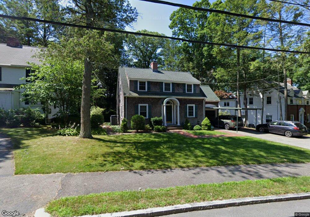
67 Dedham St Newton Highlands, MA 02461
Newton Highlands NeighborhoodEstimated Value: $1,333,000 - $1,562,000
3
Beds
3
Baths
2,098
Sq Ft
$682/Sq Ft
Est. Value
About This Home
This home is located at 67 Dedham St, Newton Highlands, MA 02461 and is currently estimated at $1,430,213, approximately $681 per square foot. 67 Dedham St is a home located in Middlesex County with nearby schools including Countryside Elementary School, Charles E Brown Middle School, and Newton South High School.
Ownership History
Date
Name
Owned For
Owner Type
Purchase Details
Closed on
Jul 23, 1998
Sold by
Rahv Betty T
Bought by
Dorfman Joel S and Dorfman Lisa H
Current Estimated Value
Home Financials for this Owner
Home Financials are based on the most recent Mortgage that was taken out on this home.
Original Mortgage
$200,000
Outstanding Balance
$40,893
Interest Rate
6.99%
Mortgage Type
Purchase Money Mortgage
Estimated Equity
$1,389,320
Create a Home Valuation Report for This Property
The Home Valuation Report is an in-depth analysis detailing your home's value as well as a comparison with similar homes in the area
Home Values in the Area
Average Home Value in this Area
Purchase History
| Date | Buyer | Sale Price | Title Company |
|---|---|---|---|
| Dorfman Joel S | $372,550 | -- |
Source: Public Records
Mortgage History
| Date | Status | Borrower | Loan Amount |
|---|---|---|---|
| Open | Dorfman Joel S | $200,000 | |
| Closed | Dorfman Joel S | $259,000 | |
| Previous Owner | Dorfman Joel S | $100,000 |
Source: Public Records
Tax History Compared to Growth
Tax History
| Year | Tax Paid | Tax Assessment Tax Assessment Total Assessment is a certain percentage of the fair market value that is determined by local assessors to be the total taxable value of land and additions on the property. | Land | Improvement |
|---|---|---|---|---|
| 2025 | $10,130 | $1,033,700 | $875,600 | $158,100 |
| 2024 | $9,795 | $1,003,600 | $850,100 | $153,500 |
| 2023 | $9,334 | $916,900 | $653,100 | $263,800 |
| 2022 | $8,931 | $849,000 | $604,700 | $244,300 |
| 2021 | $7,174 | $800,900 | $570,500 | $230,400 |
| 2020 | $8,397 | $804,300 | $570,500 | $233,800 |
| 2019 | $8,160 | $780,900 | $553,900 | $227,000 |
| 2018 | $6,138 | $723,700 | $501,800 | $221,900 |
| 2017 | $7,592 | $682,700 | $473,400 | $209,300 |
| 2016 | $7,260 | $638,000 | $442,400 | $195,600 |
| 2015 | $6,923 | $596,300 | $413,500 | $182,800 |
Source: Public Records
Map
Nearby Homes
- 116 Upland Ave
- 1308 Walnut St
- 1292 Walnut St
- 250 Woodcliff Rd
- 125 Oakdale Rd
- 36 Cannon St
- 1629 Centre St
- 1623-1625 Centre St
- 3 Glenmore Terrace Unit 2
- 1597 Centre St Unit 1597
- 1597 Centre St
- 1151 Walnut St Unit 205
- 1151 Walnut St Unit 405
- 1151 Walnut St Unit 207
- 671 Boylston St
- 19 Selwyn Rd
- 51 Carl St
- 200 Lincoln St
- 15 Buff Cir
- 628 Boylston St