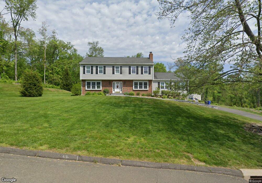
67 Firehouse Rd Trumbull, CT 06611
Daniel Farm District NeighborhoodEstimated Value: $870,000 - $977,000
4
Beds
3
Baths
3,138
Sq Ft
$295/Sq Ft
Est. Value
About This Home
This home is located at 67 Firehouse Rd, Trumbull, CT 06611 and is currently estimated at $926,907, approximately $295 per square foot. 67 Firehouse Rd is a home located in Fairfield County with nearby schools including Daniels Farm School, Hillcrest Middle School, and Trumbull High School.
Ownership History
Date
Name
Owned For
Owner Type
Purchase Details
Closed on
Jun 10, 1994
Sold by
Carrigan Michael and Carrigan Susan
Bought by
Jackson Thomas and Jackson Deborah
Current Estimated Value
Home Financials for this Owner
Home Financials are based on the most recent Mortgage that was taken out on this home.
Original Mortgage
$195,000
Interest Rate
8.29%
Mortgage Type
Unknown
Purchase Details
Closed on
Jul 1, 1988
Sold by
Kinney James
Bought by
Carrigan Michael
Home Financials for this Owner
Home Financials are based on the most recent Mortgage that was taken out on this home.
Original Mortgage
$215,000
Interest Rate
10.47%
Create a Home Valuation Report for This Property
The Home Valuation Report is an in-depth analysis detailing your home's value as well as a comparison with similar homes in the area
Home Values in the Area
Average Home Value in this Area
Purchase History
| Date | Buyer | Sale Price | Title Company |
|---|---|---|---|
| Jackson Thomas | $325,000 | -- | |
| Carrigan Michael | $356,000 | -- |
Source: Public Records
Mortgage History
| Date | Status | Borrower | Loan Amount |
|---|---|---|---|
| Closed | Carrigan Michael | $70,855 | |
| Closed | Carrigan Michael | $195,000 | |
| Previous Owner | Carrigan Michael | $211,000 | |
| Previous Owner | Carrigan Michael | $215,000 |
Source: Public Records
Tax History Compared to Growth
Tax History
| Year | Tax Paid | Tax Assessment Tax Assessment Total Assessment is a certain percentage of the fair market value that is determined by local assessors to be the total taxable value of land and additions on the property. | Land | Improvement |
|---|---|---|---|---|
| 2025 | $15,556 | $421,330 | $150,850 | $270,480 |
| 2024 | $15,130 | $421,330 | $150,850 | $270,480 |
| 2023 | $14,886 | $421,330 | $150,850 | $270,480 |
| 2022 | $14,648 | $421,330 | $150,850 | $270,480 |
| 2021 | $13,520 | $369,950 | $137,130 | $232,820 |
| 2020 | $13,263 | $369,950 | $137,130 | $232,820 |
| 2018 | $12,935 | $369,950 | $137,130 | $232,820 |
| 2017 | $12,674 | $369,950 | $137,130 | $232,820 |
| 2016 | $12,419 | $369,950 | $137,130 | $232,820 |
| 2015 | $12,661 | $372,800 | $137,100 | $235,700 |
| 2014 | $12,389 | $372,800 | $137,100 | $235,700 |
Source: Public Records
Map
Nearby Homes
- 118 Greenbrier Rd
- 3 Pam Bar Dr
- 1209 Daniels Farm Rd
- 75 Roosevelt Dr
- 121 Lewis Rd
- 119 Lewis Rd
- 93 Putting Green Rd N
- 184 Hurd Rd
- 36 Moose Hill Rd
- 43 Moose Hill Rd
- 184 Putting Green Rd
- 57 Gray Rock Rd
- 6 Brookview Dr
- 50 Hemlock Trail
- 244 Strobel Rd
- 19 Hazel Ct
- 18 Skating Pond Rd
- 101 Royals Ct
- 31 Parlor Rock Rd
- 10 Greenwood Ln
- 79 Firehouse Rd
- 64 Firehouse Rd
- 70 Firehouse Rd
- 58 Firehouse Rd
- 76 Firehouse Rd
- 82 Firehouse Rd
- 85 Firehouse Rd
- 48 Parkwood Rd
- 51 Firehouse Rd
- 48 Firehouse Rd
- 11 Blackhawk Rd
- 86 Firehouse Rd
- 51 Parkwood Rd
- 45 Firehouse Rd
- 6 Blackhawk Rd
- 92 Firehouse Rd
- 42 Firehouse Rd
- 39 Firehouse Rd
- 12 Blackhawk Rd
- 43 Parkwood Rd