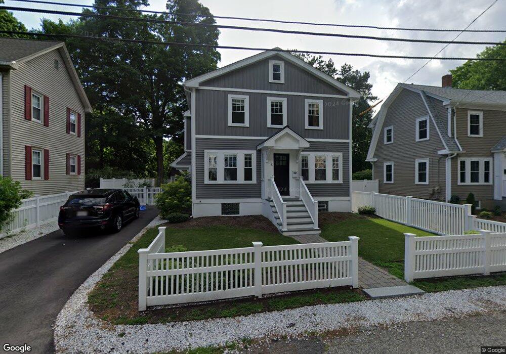
67 High Street Extension Natick, MA 01760
Estimated Value: $877,000 - $1,085,584
3
Beds
2
Baths
1,360
Sq Ft
$719/Sq Ft
Est. Value
About This Home
This home is located at 67 High Street Extension, Natick, MA 01760 and is currently estimated at $978,396, approximately $719 per square foot. 67 High Street Extension is a home located in Middlesex County with nearby schools including Natick High School, Johnson Elementary School, and J F Kennedy Middle School.
Ownership History
Date
Name
Owned For
Owner Type
Purchase Details
Closed on
Jul 6, 2007
Sold by
Perro Frederick R and Perro Deborah Ann
Bought by
Nicol Erika R and Paniszczyn Anthony
Current Estimated Value
Home Financials for this Owner
Home Financials are based on the most recent Mortgage that was taken out on this home.
Original Mortgage
$312,600
Interest Rate
6.39%
Mortgage Type
Purchase Money Mortgage
Purchase Details
Closed on
Oct 16, 1997
Sold by
Morse Brian F
Bought by
Perro Frederick R and Perro Deborah A
Purchase Details
Closed on
Dec 29, 1988
Sold by
Casali Donald W
Bought by
Morse Brian F
Create a Home Valuation Report for This Property
The Home Valuation Report is an in-depth analysis detailing your home's value as well as a comparison with similar homes in the area
Home Values in the Area
Average Home Value in this Area
Purchase History
| Date | Buyer | Sale Price | Title Company |
|---|---|---|---|
| Nicol Erika R | $390,750 | -- | |
| Perro Frederick R | $166,900 | -- | |
| Morse Brian F | $152,000 | -- |
Source: Public Records
Mortgage History
| Date | Status | Borrower | Loan Amount |
|---|---|---|---|
| Open | Morse Brian F | $313,536 | |
| Closed | Nicol Erika R | $312,600 | |
| Previous Owner | Morse Brian F | $261,750 | |
| Previous Owner | Morse Brian F | $38,000 |
Source: Public Records
Tax History Compared to Growth
Tax History
| Year | Tax Paid | Tax Assessment Tax Assessment Total Assessment is a certain percentage of the fair market value that is determined by local assessors to be the total taxable value of land and additions on the property. | Land | Improvement |
|---|---|---|---|---|
| 2025 | $11,416 | $954,500 | $379,800 | $574,700 |
| 2024 | $10,933 | $891,800 | $357,500 | $534,300 |
| 2023 | $10,652 | $842,700 | $344,100 | $498,600 |
| 2022 | $10,257 | $768,900 | $312,800 | $456,100 |
| 2021 | $4,073 | $722,900 | $294,900 | $428,000 |
| 2020 | $9,474 | $696,100 | $268,100 | $428,000 |
| 2019 | $3,967 | $415,200 | $268,100 | $147,100 |
| 2018 | $5,101 | $390,900 | $268,100 | $122,800 |
| 2017 | $4,820 | $357,300 | $236,800 | $120,500 |
| 2016 | $4,637 | $341,700 | $222,400 | $119,300 |
| 2015 | $4,590 | $332,100 | $222,400 | $109,700 |
Source: Public Records
Map
Nearby Homes
- 47 High St
- 25 Forest Ave
- 216-218 S Main St
- 6 Ambler Ct
- 16 West St
- 8 Floral Avenue Extension
- 8 Floral Ave Unit 8
- 58 W Central St
- 48 S Main St Unit 7
- 49 Summer St
- 15 Church St Unit 3
- 11 Avon St
- 6B Lincoln St Unit 6B
- 4B Lincoln St Unit 4B
- 5 Wilson St Unit 5A
- 34 N Main St Unit 2
- 3 Wilson St Unit 3B
- 2 Yuba Place
- 16 Wayside Rd Unit 14
- 48 Graystone Ln
- 69 High Street Extension
- 65 High St
- 65 High Street Extension
- 66 High Street Extension
- 64 High Street Extension
- 70 High Street Extension
- 11 Bennett St
- 11 Bennett St Unit 1
- 11 Bennett St Unit 11
- 59 High St
- 34 Curve St
- 36 Curve St
- 40 Forest Ave
- 60 High St
- 22 Curve St
- 2 Bennett St
- 2 Bennett St
- 57 High St
- 38 Forest Ave
- 58 High St