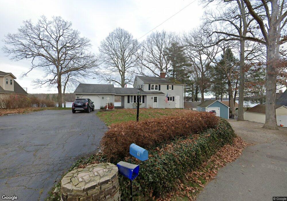
67 John Hand Dr Coventry, CT 06238
Estimated Value: $687,348 - $848,000
About This Home
This home is located at 67 John Hand Dr, Coventry, CT 06238 and is currently estimated at $766,837, approximately $394 per square foot. 67 John Hand Dr is a home located in Tolland County with nearby schools including George Hersey Robertson School, Coventry Grammar School, and Capt. Nathan Hale School.
Ownership History
We collect this data history from publicly available records. To have your information removed, we recommend requesting removal directly through your county’s website.
Purchase Details
Purchase Details
Purchase Details
Home Financials for this Owner
Home Financials are based on the most recent Mortgage that was taken out on this home.Home Values in the Area
Average Home Value in this Area
Purchase History
We collect this data history from publicly available records. To have your information removed, we recommend requesting removal directly through your county’s website.
| Date | Buyer | Sale Price | Title Company |
|---|---|---|---|
| -- | None Available | ||
| -- | None Available | ||
| -- | -- | ||
| $500,000 | -- | ||
| -- | -- | ||
| $500,000 | -- |
Mortgage History
We collect this data history from publicly available records. To have your information removed, we recommend requesting removal directly through your county’s website.
| Date | Status | Borrower | Loan Amount |
|---|---|---|---|
| Previous Owner | $50,000 | ||
| Previous Owner | $399,950 |
Tax History
We collect this data history from publicly available records. To have your information removed, we recommend requesting removal directly through your county’s website.
| Year | Tax Paid | Tax Assessment Tax Assessment Total Assessment is a certain percentage of the fair market value that is determined by local assessors to be the total taxable value of land and additions on the property. | Land | Improvement |
|---|---|---|---|---|
| 2025 | $11,046 | $464,900 | $283,400 | $181,500 |
| 2024 | $10,196 | $306,100 | $190,100 | $116,000 |
| 2023 | $9,716 | $306,100 | $190,100 | $116,000 |
| 2022 | $9,535 | $306,100 | $190,100 | $116,000 |
| 2021 | $9,535 | $306,100 | $190,100 | $116,000 |
| 2020 | $9,541 | $306,100 | $190,100 | $116,000 |
| 2019 | $9,856 | $306,100 | $190,100 | $116,000 |
| 2018 | $8,768 | $272,300 | $172,800 | $99,500 |
| 2017 | $8,714 | $272,300 | $172,800 | $99,500 |
| 2016 | $8,496 | $272,300 | $172,800 | $99,500 |
| 2015 | $8,496 | $272,300 | $172,800 | $99,500 |
| 2014 | $7,627 | $267,900 | $166,400 | $101,500 |
Map
- 51 John Hand Dr
- 112 John Hand Dr
- 5 Avery Shores
- 0 Seneca Trail
- 0 Donovan Ave Unit 24180585
- 0 Donovan Ave Unit 24180587
- 0 Donovan Ave Unit 24180512
- 91 Washburn Ave
- 152 Cheney Ln
- 34 Avery Shores
- 0 Hinkel Mae Dr
- 113 Ridgewood Trail
- 21 Arlington Rd
- 2478 Main St
- 24 Barry Rd
- 0 Englewood Trail Unit 24173868
- 285 Woodland Rd
- 220 Springdale Ave
- 109 Sam Green Rd
- 16 Gardner Tavern Rd
- 151 W Shore Dr
- 141 W Shore Dr
- 159 W Shore Dr
- 75 John Hand Dr
- 59 John Hand Dr
- 72 John Hand Dr
- 81 John Hand Dr
- 53 John Hand Dr
- 96 John Hand Dr
- 87 John Hand Dr
- 119 W Shore Dr
- 50 John Hand Dr
- 93 John Hand Dr
- 135 W Shore Dr
- 99 John Hand Dr
- 48 John Hand Dr
- 110 John Hand Dr
- 120 W Shore Dr
- 43 John Hand Dr
- 105 John Hand Dr
Ask me questions while you tour the home.