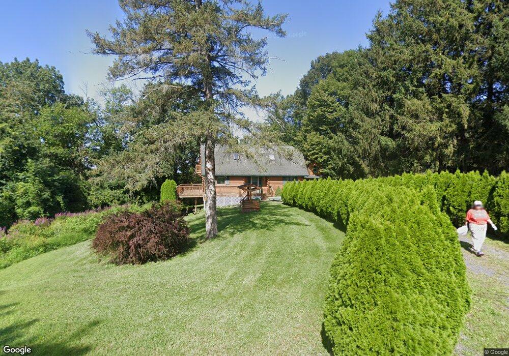
67 Lynk Rd Hudson, NY 12534
Estimated Value: $410,000 - $631,000
3
Beds
2
Baths
1,582
Sq Ft
$313/Sq Ft
Est. Value
About This Home
This home is located at 67 Lynk Rd, Hudson, NY 12534 and is currently estimated at $494,944, approximately $312 per square foot. 67 Lynk Rd is a home with nearby schools including Germantown Elementary School and Germantown Junior/Senior High School.
Ownership History
Date
Name
Owned For
Owner Type
Purchase Details
Closed on
Nov 17, 2022
Sold by
Mcnally John J and Mcnally Theresa P
Bought by
John & Theresa Mcnally Ft
Current Estimated Value
Purchase Details
Closed on
Mar 12, 2012
Sold by
Bartolo Charles
Bought by
Mcnally John J
Purchase Details
Closed on
Apr 22, 2011
Sold by
Gorlan Rolf
Bought by
Bartolo Charles
Purchase Details
Closed on
Jan 17, 2006
Sold by
Lynk Holding Llc
Bought by
Lynk Donald
Purchase Details
Closed on
May 22, 2002
Sold by
Lynk Scott
Bought by
Gorlan Rolf
Purchase Details
Closed on
Mar 16, 2001
Create a Home Valuation Report for This Property
The Home Valuation Report is an in-depth analysis detailing your home's value as well as a comparison with similar homes in the area
Home Values in the Area
Average Home Value in this Area
Purchase History
| Date | Buyer | Sale Price | Title Company |
|---|---|---|---|
| John & Theresa Mcnally Ft | -- | None Available | |
| Mcnally John J | $220,000 | Christopher Watz | |
| Bartolo Charles | $152,860 | Koweek, Cranna & Mcevoy, Pc | |
| Lynk Donald | -- | James Carlucci | |
| Gorlan Rolf | $162,500 | Jacqueline Martin | |
| -- | -- | -- |
Source: Public Records
Tax History Compared to Growth
Tax History
| Year | Tax Paid | Tax Assessment Tax Assessment Total Assessment is a certain percentage of the fair market value that is determined by local assessors to be the total taxable value of land and additions on the property. | Land | Improvement |
|---|---|---|---|---|
| 2024 | $4,052 | $159,675 | $36,300 | $123,375 |
| 2023 | $4,174 | $159,675 | $36,300 | $123,375 |
| 2022 | $4,010 | $159,675 | $36,300 | $123,375 |
| 2021 | $4,241 | $159,675 | $36,300 | $123,375 |
| 2020 | $4,259 | $159,675 | $36,300 | $123,375 |
| 2019 | $1,558 | $159,675 | $36,300 | $123,375 |
| 2018 | $4,052 | $159,675 | $36,300 | $123,375 |
| 2017 | $4,136 | $159,675 | $36,300 | $123,375 |
| 2016 | $3,999 | $159,675 | $36,300 | $123,375 |
| 2015 | -- | $159,675 | $36,300 | $123,375 |
| 2014 | -- | $159,675 | $36,300 | $123,375 |
Source: Public Records
Map
Nearby Homes
- 351 County Route 19
- 238 County Route 10
- 3927 U S Highway 9
- 0 County Route 19 Unit 156770
- 327 Scudderhook Rd
- 649 Route 19 Unit 26
- 134 Lockwood Rd
- 0 Lockwood Rd
- 16 Spruce St
- 2322 Us Route 9
- 0 County Route 19
- 160 Willowbrook Rd
- 134 Willowbrook Rd
- 202 Buckwheat Rd
- 202 Buckwheat Bridge Rd
- 36 Bacon Dr
- 1049 County Route 19
- 0 Taghkanic Rd Unit KEY850911
- 71 Buckwheat Bridge Rd
- 59 Buckwheat Rd
- 71 Lynk Rd
- 75 Lynk Rd
- 56 Lynk Rd
- 409 County Route 19
- 395 County Route 19
- 1 County Route 19
- 0 Cty Rte 10
- 0
- 19 Cr
- 23 County Route 10
- 31 County Route 10
- 34 Lynk Rd
- 85 County Route 10
- 117 County Route 19
- 438 County Route 19
- 399 County Route 19
- 438 County Route 19
- 2 County Route 19
- 381 County Route 19
- 16 Twin Dr