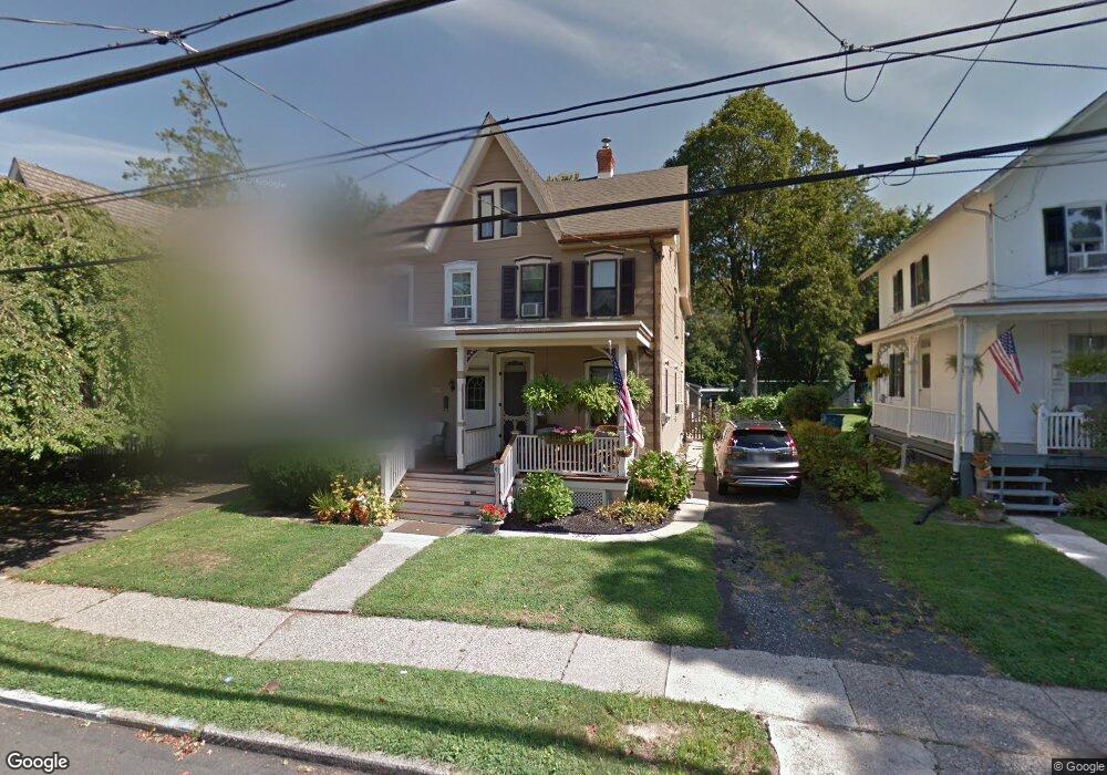
67 N Clinton St Doylestown, PA 18901
Estimated Value: $429,000 - $559,000
3
Beds
1
Bath
1,284
Sq Ft
$380/Sq Ft
Est. Value
About This Home
This home is located at 67 N Clinton St, Doylestown, PA 18901 and is currently estimated at $487,971, approximately $380 per square foot. 67 N Clinton St is a home located in Bucks County with nearby schools including Doyle El School, Lenape Middle School, and Central Bucks High School-West.
Ownership History
Date
Name
Owned For
Owner Type
Purchase Details
Closed on
Sep 12, 2017
Sold by
Benner Steven G and Knowles Karen
Bought by
Benner Steven G and Benner Karen Knowles
Current Estimated Value
Home Financials for this Owner
Home Financials are based on the most recent Mortgage that was taken out on this home.
Original Mortgage
$145,000
Outstanding Balance
$121,342
Interest Rate
3.89%
Mortgage Type
Credit Line Revolving
Estimated Equity
$366,629
Purchase Details
Closed on
Jul 2, 2009
Sold by
Federal Home Loan Mortgage Corporation
Bought by
Benner Steven G and Knowles Karen
Home Financials for this Owner
Home Financials are based on the most recent Mortgage that was taken out on this home.
Original Mortgage
$186,000
Interest Rate
5.58%
Mortgage Type
Purchase Money Mortgage
Purchase Details
Closed on
Mar 6, 2009
Sold by
Carr James A
Bought by
Federal Home Loan Mortgage Corp
Create a Home Valuation Report for This Property
The Home Valuation Report is an in-depth analysis detailing your home's value as well as a comparison with similar homes in the area
Home Values in the Area
Average Home Value in this Area
Purchase History
| Date | Buyer | Sale Price | Title Company |
|---|---|---|---|
| Benner Steven G | -- | None Available | |
| Benner Steven G | $232,500 | Land Title Svcs Of Nj Inc | |
| Federal Home Loan Mortgage Corp | $1,016 | None Available |
Source: Public Records
Mortgage History
| Date | Status | Borrower | Loan Amount |
|---|---|---|---|
| Open | Benner Steven G | $145,000 | |
| Closed | Benner Steven G | $166,500 | |
| Closed | Benner Steven G | $186,000 |
Source: Public Records
Tax History Compared to Growth
Tax History
| Year | Tax Paid | Tax Assessment Tax Assessment Total Assessment is a certain percentage of the fair market value that is determined by local assessors to be the total taxable value of land and additions on the property. | Land | Improvement |
|---|---|---|---|---|
| 2025 | $2,594 | $14,400 | $3,120 | $11,280 |
| 2024 | $2,594 | $14,400 | $3,120 | $11,280 |
| 2023 | $2,471 | $14,400 | $3,120 | $11,280 |
| 2022 | $2,437 | $14,400 | $3,120 | $11,280 |
| 2021 | $2,410 | $14,400 | $3,120 | $11,280 |
| 2020 | $2,384 | $14,400 | $3,120 | $11,280 |
| 2019 | $2,358 | $14,400 | $3,120 | $11,280 |
| 2018 | $2,329 | $14,400 | $3,120 | $11,280 |
| 2017 | $2,304 | $14,400 | $3,120 | $11,280 |
| 2016 | $2,304 | $14,400 | $3,120 | $11,280 |
| 2015 | -- | $14,400 | $3,120 | $11,280 |
| 2014 | -- | $14,400 | $3,120 | $11,280 |
Source: Public Records
Map
Nearby Homes
- 37 N Clinton St
- 130 N Clinton St
- 20 E Court St
- 69 E Oakland Ave
- 1 Barnes Ct
- 195 Lafayette St
- 146 N Church St
- 110 E Ashland St
- 146 E Court St
- 155 E Oakland Ave
- 236 Green St
- 9 Mill Creek Dr
- 89 Homestead Dr
- 403 S Main St Unit S201
- 3 Steeplechase Dr
- 418 North St
- 6 Edison Ln Unit 1
- 339 E Ashland St
- 121 Cottage St
- 114 Progress Dr
- 69 N Clinton St
- 73 N Clinton St
- 59 N Clinton St
- 57 N Clinton St
- 79 N Clinton St
- 81 N Clinton St
- 49 N Clinton St
- 87 N Clinton St
- 64 N Clinton St
- 68 N Clinton St
- 74 N Clinton St
- 89 N Clinton St
- 45 N Clinton St
- 102 Decatur St
- 80 N Clinton St
- 110 Decatur St
- 60 N Clinton St
- 48 N Clinton St
- 95 Wood St
- 80 Hohlbain's Alley